
 |
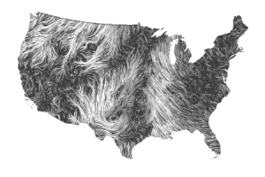
| WIND MAP of March 20, 2012 SEE ANIMATION FOR CURRENT CONDITIONS |
Unlike most things that move, winds are named for the direction from which they blow, because that gives some indication of what it might bring. In Bridgewater, Massachusetts, a wind from the northwest is likely to bring drier, cooler air compared to a wind from the southwest, which would usually bring air that is both warmer and moister. Other movements, such as those of a vehicle, human migration, or a herd of caribou, are named by the direction toward which they are moving.

Wind is a perpetual resource, meaning that it is always available, whether humans use it or not. Renewable resources are those that can be used indefinitely, as long as they are not overused, while non-renewable resources become less available every time they are used. Because it is perpetual, wind is potentially very valuable, but it also varies in strength from place to place and over time. For that reason, people are investigating the geographic patterns of wind in order to find the best places to harness wind energy.
One result of this work -- combined with internet technology and some clever programming -- is Wind Map, an animated page that allows people to visualize the wind conditions in the United States, almost in real time. The gallery shows how much these patterns can change from day to day. This is a very new effort; the programmers are currently looking for sources of data that would allow them to create a similar visualization for the entire world.
Important: Comparing these patterns to national weather maps, one will notice that the wind directions do not correspond exactly with weather patterns and the movements of fronts and storm systems. This is because ground-level winds are measured at 1.5 meters above the surface, whereas weather systems are moved by winds much higher in the atmosphere that are not influenced much by friction and can be strongly influenced by the Coriolis effect.
No comments:
Post a Comment