EarthView team bios, guidelines, and more.

Friday, October 13, 2017

Brennan School, Attleboro -- Oct 13

N 41° 56' 15" 
W 71° 18' 29"
(including how to look them up by address)

The EarthView team is making its first visit to the Brennan School in Attleboro, located about 15 miles to the east of our home base on the main campus of Bridgewater State University.

BSU also has a small campus in Attleboro itself, at 11 Field Road. According to Google Maps, it is only 11 or 12 minutes away from the Brennan School by car.


During our visit, the EarthView team will be explaining the location of the wildfires in California. This tragedy is a perfect example of geography's three questions:
Where is it?Why is it there?So what?
In this case, the "where" question is a very distinctive pattern of two linear clusters along either side of California's Central Valley.
 The timing and location of these fires has to do with the famous Santa Ana winds that affect California (U.S.A.) and Baja California (Mexico). As air cools at high elevations, it becomes more dense, and the high pressure forces it downhill. It becomes drier as it descends, and moves more rapidly as it is pushed through narrow canyons. 

The result is that dust, smoke, and hot air is pushed down slopes, and even far out into the Pacific Ocean.
The reason that the winds come at a predictable time every year is that the global circulation of the atmosphere shifts with the sun. In New England, the most important variables from season to season have to do with temperature and the length of the day, but in many parts of the world, the direction of prevailing winds is even more important.

Thursday, July 20, 2017

Sanctuary, Marshfield -- July 20

N 42° 05' 50" W 70° 43' 45"
(including how to look them up by address)

The EarthView is very pleased to be part of the Sanctuary Day Camp at the Sanctuary congregation in Marshfield. Campers have been learning and celebrating many different things about the earth, its environments and peoples. Throughout the day, learners of all ages were able to use EarthView and our Hobo-Dyer-Mead south-up map to locate places they were interested in.
EarthView is a physical map; it works well in combination with the
 Hobo-Dyer-Mead map from ODT Publishing.
One of the places we mentioned to campers is the city of Macapá, the capital of the State of Amapá, Brazil. It is a city that is located where the Equator meets the Atlantic Ocean. Famously, its main soccer (football) stadium (Milton Stadium Souza Corrêa) is positioned so that opposing teams are in opposite hemispheres, with the centerfield line at 0 degrees latitude!

Saturday, July 15, 2017

EarthView Team Travels

The three permanent members of the EarthView team are geographers with a passion for exploring the world through maps, globes, movies, books, articles, food, and conversation. Together we have spent more than a CENTURY in the classroom teaching of geography, where we learn from our students, as we do with each EarthView visit. Just traveling with EarthView itself gives us more ways to explore the world, mostly the small but fascinating corner of it we find in Massachusetts.

Another way we are fortunate to have learned geography is from visiting or even living in other countries. The maps below are our "life lists" of international experience, and for all three of us, the list is growing steadily.

Many of the students who visit us in EarthView we born in other countries, or have parents who were. The chances are fairly high that one of the EarthView team members has been to those home countries, or perhaps speaks the language.

Dr. Hayes-Bohanan has the shortest list so far.


Create Your Own Visited Countries Map

Thursday, June 15, 2017

Somerset Middle School, May 23 & June 16

N 41° 44' 20" W 71° 09' 50"
(including how to look them up by address)

The EarthView team could almost use a canoe to reach Somerset Middle School, one of several schools we are visiting for the first time ever as this school year ends. In fact, we are making our first and second appearances at Somerset Middle School.

Somerset is located at the mouth of the Taunton River -- designated a United States Wild & Scenic River -- where it reaches the sea. Bridgewater is located where the Taunton River begins, at the confluence of the Town and Nemasket Rivers. Very close to the Bridgewater State University Campus is a place called Town River Landing, designed by local people and state officials specifically for boat trips down the Taunton River. But such an adventure would take all day, so EarthView is arriving as it usually does, by car.


During our visits we try to point out highlights from recent news about geography, and we recently learned about an interesting observation that was made in a place we talk about quite often in EarthView: the Southern Ocean.

This is the world's "newest" ocean, designated in the year 2000 to refer to the southernmost portions of the Atlantic, Indian, and Pacific Oceans. All of the other oceans are defined by the geology of the ocean floors, but the Souther Ocean is defined by surface winds and currents, which are quite important. As described in the How Many Oceans article from NOAA, most authorities agree that the Southern Ocean includes all of the waters poleward of 60°S. The article mentions that not all authorities agree, and this week's story suggests that New Zealand is one of them.

The story is this: scientists in New Zealand recently measured the largest wave ever recorded. Shortly after installing a buoy specifically to measure waves in this very active ocean, it was moved by a single wave 64 feet tall! For comparison, EarthView is 20 feet tall. Imagine being in a boat that is picked up by a wave three times that high!
Image: Stock image of a boat in rough seas from the article about this wave. The real wave was not photographed, and would have been MUCH bigger than this.
We should keep in mind that this wave was recorded very soon after the buoy was put in place, it might record an even higher one in the future.

The story is told in Awesome Ocean and on the web site of Met Ocean, which made the discovery. The web site also has a page for live monitoring of the buoy, which is located between New Zealand and Antarctica, 11 kilometers south of Campbell Island.
This means that the buoy is at about 52°40' S, or several hundred miles north of what most people consider the boundary of the Southern Ocean. In EarthView, the more common boundary is easy to spot: it corresponds to the edge of the dark-blue area we are able to walk on inside.

When you are inside EarthView, try to think about the locational factors that could make such a record-setting wave possible near Cambbell's Island.


Friday, June 2, 2017

Kennedy School, Woburn -- June 2

N 42 ° 29' 34" W 71 ° 08' 46"
Learn more about Lat/Long (including how to look them up by address)

The EarthView team has visited the Kennedy School twice before, in 2010 and 2011. We are very pleased to be back, where we will explore the world with sixth graders who have been studying world geography. EarthView is a great place to visualize the global arrangement of tectonic plates, and their implications for earthquakes and volcanoes. Both have been the subject of a lot of the geography lessons at Kennedy this year.


Thursday, May 18, 2017

David Mindess School, Ashland -- May 19

42º 15' 50" N
71º 27' 40" W

Learn more about Lat/Long

The EarthView team is pleased to visit the Mindess School, located in the town of Ashland. It is in an area known as Metro West, meaning that it is in the western area of Boston's suburbs.


When preparing for our visit, the first thing we noticed is that the entire town of Ashland is preparing for a program called Courageous Conversations, for community youth and adults. 

It is good to be visiting a community that is committed to inclusion and open discussions. A key lesson from EarthView is that we are all connected on a single planet.

The second thing we noticed is that Ashland is the second town along the 26.2-mile long route of the world-famous Boston Marathon, which took place just a month before our visit. Ashland is part of the rural, mostly downhill part of the race. Ashland runners raised more than $30,000 for local charities during the 2017 marathon. 

Almost 30,000 people ran in the most recent race, representing every U.S. state and territory, and almost 100 countries around the world. This means that for one day in April, Ashland was probably the most international small town on the planet.
The Boston Marathon is named for the historic run of a soldier from the city of Marathon to the Greek capital Athens in 490 B.C. That route was run again in the 2004 Olympics and remains popular for runners wanting to try the original route. Notice the elevation profile at the bottom of this route map. Elevation and temperature are two very important factors for the runners.

Another interesting marathon took place in New York City in 1908 -- after the tradition had begun in Boston, but before the modern route in New York City was established. Inside Madison Square Garden, Johnny Hayes and Dorando Pietri were the only participants in an indoor marathon -- 262 laps of just one-tenth of a mile. As boring as that sounds, the arena was full of spectators!

Plus: It's About Time!


People in Ashland are very interested in clocks. The local high school sports teams are even known as Clockers! The town is so proud of inventor Henry E. Warren that its other elementary school is named for him. The connection is this: Mr. Warren invented the electric clock. 

Although the electric clock is among the 135 inventions for which he won patents, he never intended to invent it. Rather, he was trying to improve instrument that regulate the flow of water through machinery, at a time when many industries in Massachusetts still used water to power their tools. Master of Time is a short article about his life and the connections among water, power, and time that Henry Warren understood so well.

Clocks are of great importance to geographers, because they are essential for finding longitude. Geographers know how to estimate the latitude wherever they are, as long as they can see the noon sun and they know the current date. Because longitude is arbitrary -- based solely on the position of the Royal Naval Observatory in the United Kingdom -- it cannot be determined by observation alone. 

British inventor John Harrison realized the importance of this, and invented the clock, so that ships at sea could use to compare Greenwich time with local time. For this he won the Longitude Prize.
Harrison designed .a clock 300 years ago that he thought would be more accurate than any other, but he was not able to build it. Using modern materials, horologists (clock experts) built this one, and put it in a sealed container in the foundation of the Royal Naval Observatory in Greenwich, directly on the Prime Meridian. In 2015, they confirmed that it is the most accurate mechanical clock ever constructed!

Lagniappe: Brazzzzzil

We were pleased to meet quite a few students with ties to Brazil -- either born in the country or having parents who were. Most of these connections are in the state of Minas Gerais, which literally means "General Mines" and is the source of many minerals in Brazil.

One class mentioned that they had studied the problem of bees that are disappearing because of deforestation in the Amazon basin. EarthView team member Dr. Hayes-Bohanan mentioned that he had actually encountered Africanized bees when doing field work in Rondônia in 1996. From another geographer who was studying at the same time, he learned that wherever the forests had been cleared, Africanized bees competed for territory and replaced ordinary honey bees. For more of the story, scroll down to What's the Bzzzzzzzzz? on his journal Folha da Frontera.

Friday, May 12, 2017

Rumney Marsh Academy, Revere -- May 12

42º 24' 47" N
71º 00' 12" W

Learn more about Lat/Long

Rumney Marsh Academy is a school that the EarthView team enjoys visiting each year, because students there study geography throughout the year. It is especially fun to arrive late in the school year, when the geography learning among sixth graders has been going on for months!

Visit our 2016 Rumney-Marsh post and earlier posts for information about our previous visits and about the marsh (wetland) for which the school is named. You can also read about its nearest neighbor -- a famous candy company. How many middle school students are lucky enough to be across the street from a candy factory? It is like Willy Wonka, but in real life.

Water Volumes

Our visits inside of EarthView always begin with a discussion of the Earth's water, and the fact that the vast majority of it is in forms (saltwater or ice) that humans cannot use for drinking, bathing, irrigation, or industry. We have this discussion in terms of percentages, but today a student asked what the total volume of the water would be. "Millions of cubic miles," we said, promising to look up the actual figures.

According to the United States Geological Survey (USGS), the volume of water on the earth is 332,500,000 cubic miles (mi3), or 1,386,000,000 cubic kilometers (km3). The image below shows what the earth would look like if all of the water were removed from oceans, ground water, streams, and lakes.
The largest blue sphere represents all of the water on earth. The smaller sphere -- situated over Kentucky in the United States -- represents only the liquid, fresh water. The tiniest sphere of all -- a dot that appears to rest on Georgia -- represents all of the surface water. Of that, about 20 percent is in the Amazon River Basin, and another 20 percent is in Lake Baikal in Russia. Learn more at the USGS How Much Water? page.

NEW (May 30, 2017): Speaking about this with the geography teachers at our EarthView Institute, we realized that we can update our presentation about water to include not only percentages, but also the absolute volumes of the various ways water is stored. Using the USGS site mentioned above and refreshing our memory of sphere-related formulae with the sphere calculator page, we created a new spreadsheet detailing earth's water at an EarthView scale. For example, we learned that all of the fresh liquid water at or above the earth's surface could fit inside a ping-pong ball at the scale of EarthView!

South-Up Map

We also spent a lot of time at our Hobo-Dyer-Mead map learning about the importance of relative size. An interesting way to learn more is to use the TrueSize web site, which allows viewers to select a country or U.S. state, and visually drag it to other parts of the world for comparison.
The "Lower 48" portion of the United States, for example, is about the size of Brazil. Often, the familiar Mercator projection gives us the wrong idea of the relative size of places.


Friday, May 5, 2017

Clifford Marshall School, Quincy -- Cinco de Mayo

42° 15' 10" N
71° 0' 03" W
Learn more about Lat/Long (including how to look them up by address)
Also, compare today's coordinates to those of other recent Earth View outings, near and far!

This was our second visit to the Marshall School. The EarthView team knew that the students and families of Clifford Marshall School have come to Quincy from many places, and that the school community celebrates this. So we asked each of the third and fourth graders who came into EarthView to tell us where their families come from. We pointed them out during our visit and then put them on.a Google Map. With just one point in the center of each country of origin, we were able to make this quick map of the Marshall School community.
 

Friday, April 28, 2017

Alden Elementary, Duxbury -- April 28

42° 02' 48"N
70° 40' 49"W
(Center of the stage at the Duxbury Performing Arts Center)
Learn more about Lat/Long (including how to look them up by address)
Also, compare today's coordinates to those of your own home, family members, and other EarthView outings, near and far! 

Alden School students walked through their school to the Duxbury
Performance Arts Center, where EarthView was on stage for the day!
Many thanks to the Alden PTO and to PAC director Tony Kelso.
Duxbury's Landscapes -- from the Duxbury town web site
EarthView has been in many towns near Duxbury in the past, but the Alden Elementary visit is our visit to Duxbury itself. The map below shows a purple pin for each school visit in the area. Click on EarthView Experience to see all of the places EarthView has traveled.


Members of the EarthView team have good friends in Duxbury, from whom we know that the Duxbury Beach is something of which people in the town are quite proud. It is home to migratory birds that require special care, and an entire organization exists to protect and promote the beaches of Duxbury.

Our visit took place on Maryland Day -- the anniversary of Maryland's admission to the Union (becoming one of the United States) on April 28, 1788.
Dr. Hayes-Boh celebrating Maryland's day to shine!
Dr. Hayes-Bohanan and his wife Pamela (a BSU librarian) spent the year 2010 recognizing each of the United States on the anniversary of its admission. We read books, watched movies, and prepared food for each celebration. Maryland Day was a special celebration, because it is where they were married on May 9, 1987.

People from Maryland tend to be very proud of its flag, which is based on the heraldry of two families -- Baltimore and Calvert -- that helped to found the British colony that eventually became the state. Many Marylanders are also passionate about the Maryland blue crab, which grows in the Chesapeake Bay. The flag and the food are combined in a magnetic decal on Dr. Hayes-Bohanan's car that celebrates Maryland.
This is something people all over the world do -- sharing symbols that represent the sense of place of their home town or region. What are some examples of sense of place in your own town or in places that are important to your family? Examples could be foods, sports teams, landmarks, or many other features.

Friday, April 7, 2017

Frolio Middle School, Abington -- April 7

42° 07' 06"N
70° 56' 47"W
Learn more about Lat/Long (including how to look them up by address)
Also, compare today's coordinates to those of other recent EarthView outings, near and far! Next year, Frolio student's will be asked to compare the coordinates of this gym and the gym in the new Abington Middle School.


The EarthView team is very pleased to return to Frolio, which we have visited every year since 2010. We always find students who have been actively engaged in learning geography, which we can tell because of the good questions they ask during our visits. We enjoy giving students a different way to look at the places and concepts they have been studying in their excellent geography classes throughout the year.

This will be the last time EarthView will be in Frolio's charming all-wood gymnasium, as a new school is under construction. Although we are happy that Frolio's teachers and students will have upgraded facilities, we will miss this gym, whose architecture is typical of public projects built by the Work Progress Administration in the 1930s.

During today's visit, some classes learned about another kind of public-works project: dams.
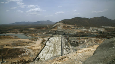
Grand Ethiopian Renaissance Dam under construction in 2015
Specifically, we showed the location of this dam, which is under construction in Ethiopia. The Grand Ethiopian Renaissance Dam will be enormous, creating a reservoir twice as large as Lake Meade, which is the reservoir behind the Hoover Dam in Nevada and Arizona. The purpose of the Ethiopian dam will be to provide renewable electricity in Ethiopia. It is located on the Blue Nile, a major tributary of the Nile.

With a capacity of 6,000 megawatts, it could provide electricity to about 9,000,000 households in the United States. Ethiopia has 94,000,000 people in about 20,000,000 households. With its lower level of electricity consumption, this dam will provide enough electricity to serve all of that county's household needs.

Although this is very good news for Ethiopian households, dams usually have both positive and negative effects. In the case of this dam, it is one of several problems for the Nile Basin, and especially for people and crops in Egypt. This is combined with the rise of sea level at the mouth of the Nile and other problems that some scientists call the Vanishing of the Nile.

EarthView team member Kevin Bean carting EarthView away from the American Association of Geographers meeting in Boston. The AAG recently changed its name from the Association of American Geographers. What is the difference?
This year's Frolio visit is in the middle of the annual meeting of the American Association of Geographers. EarthView has been a popular attraction at the conference, which has brought thousands of professional geographers to the Hynes Convention Center in Boston, along with publishers and technology companies that employ and serve geographers.
On Thursday and Saturday, EarthView has a spot at the entrance to the the HUUUUGE exhibit hall, next to interactive displays from Google and esri, each of which is a major provider of software for Geographic Information Systems and digital mapping.

Lagniappe: Farewell to Frolio

As mentioned above, the students and teachers of Frolio will soon be in more modern, spacious facilities, and we are glad for them. Like many of them, though, the EarthView team will miss this charming building, which began as Abington High School 80 years ago.

It was built during the Great Depression, one of thousands of projects around the United States that were funded by the Federal government under the leadership of President Franklin Roosevelt. The idea was to invest money -- even to borrow money -- in projects that would be good investments and would provide jobs for those who wanted to work but could not find employment.

The building later served as a middle school, named for a beloved teacher and principal. The EarthView team took a few photos today to remember this building, and we look forward to many more years with the Abington geographers in their new space.
Architectural details

Charles Frolio's portrait, in the main entrance

Memorial for Charles Frolio
Details of the Federal Project that built the school

The local committee that oversaw the project; today such a committee would almost certainly include both men and women. A woman did serve as the committee secretary, and her name is what is called an apternym, because it is apt for the job.
Our favorite part of the building, of course, is the gym itself. We visit a lot of gyms, and this is among the most charming. It has subtle architectural details of its own, and we love the wooden bleachers. It will continue to serve as a venue for community games.
EarthView at Frolio for the last time.

Friday, March 24, 2017

Garfield Middle, Revere -- March 24

42° 24' 12" N
70° 59' 34" W
Learn more about Lat/Long (including how to look them up by address)
Also, compare today's coordinates to those of other recent EarthView outings, near and far!


The EarthView team is excited to be returning to Garfield Middle School, which we visited for the first time in May 2016. Our blog post from that visit includes photos of the magnificent flags that adorn Garfield's hallways.
Garfield is a school that loves geography!
This year, our visit comes during the week of World Water Day. During our EarthView program, we always discuss the importance of water, and how it is that we must conserve water, even though the planet has millions of cubic miles of it!
Learn more about World Water Day from the United Nations
It is very fitting that this is the week that a court in New Zealand ruled that the Whanganui River is legally a person, with all of the rights and responsibilities that human persons have. The river flows 180 miles from Mt Tongariro to the Tasman Sea, and is of special importance to the Maori people, who sought this legal designation and will serve as the river's guardians.

Friday, March 17, 2017

Spofford Pond School, Boxford -- March 17

42°41'46"N 
71°01'02"W
(Visit more about Lat/Long for ideas that combine math and geography learning. This is our second visit to Spofford Pond, and it remains the farthest north we have taken EarthView.) 

The EarthView team is always pleased to return to Spofford Pond School. Even though it is farther from our campus than most of the schools we visit, we always find it worth the journey, because the social studies classes at Spofford Pond include so much geography that we know we will find students who are eager for the EarthView experience.

Many of our previous Spofford Pond blog posts include information about the local geography of Boxford. Today's blog, though, will emphasize a few matters from farther afield. First is an event that occurred yesterday and that we mentioned during our Spofford Pond visit.

Yesterday, at 37°45' N, 15°00' E tourists were very surprised by an eruption of Mt. Etna, the most active volcano in Europe. Even though it is frequently active, prior movements usually allow the volcanologists to close the volcano to visitors prior to an eruption. Yesterday's eruption, however, was quite sudden, and injured some tourists and journalists who were on the volcano at the time.


The first satellite image was captured by Sentinel 2, part of the European Space Agency Copernicus program.
Learn more about the world's volcanoes from the SI Global Volcanism Program.
Information on every volcano


We also presented some challenges about latitude and longitude. If one circled the world at the same latitude (within a degree) of Spofford Pond, what three world capitals could you encounter? What if you circled half world at the same longitude? (Answers at the bottom of this article.)

HINT: For the first answer, two of the cities are in the exact same location; the other is the capital of a country whose name is also a U.S. state. 
For the second answer, the two cities are named for saints.

Lagniappe:

Happy St. Patrick's Day! In honor of the occasion, some Spofford Pond students were treated to a dad-level riddle by Dr. Hayes-Bohanan.

Q: Why is Ireland so wealthy?
A: It's capital is always Dublin. (Say it out loud.)


LAT/LONG Answers ... keep scrolling down
.
.
.
.
.
.
.
.
.
.
Latitude: Vatican City, Rome, and Tbilisi
Longitude: Santo Domingo, Santiago 

Friday, February 17, 2017

Littleton Middle School - February 17

42° 32' 32" N
71° 29' 14" W 
Learn more about Lat/Long (including how to look them up by address)
Also, compare today's coordinates to those of other recent EarthView outings!


View Larger Map


The EarthView team is delighted to be returning to Littleton Middle School, where excellence in geography education is a hallmark of sixth-grade social studies.

One of the concepts we explored inside EarthView is the idea of antipodes -- places that are on precisely opposite sides of the planet. Although a lot of people think that China is opposite the United States, it cannot be, since both are in the Northern Hemisphere. 

The antipode of Littleton Middle School is in the Indian Ocean, at S 42°32'32" E 108°30'46". These coordinates are found by using the same latitude but with the opposite direction, and by subtracting the longitude from  180 degrees before switching hemispheres.

During our 2016 visit to Littleton, our colleague Dr. Hellstrom from Bridgewater State spoke about his experience studying weather and climate change in the Andes Mountains of Peru. This year, we discussed a new BSU course that we will offer in Peru in July 2017 that will include Dr. Hellstrom's weather stations and coffee and cacao (chocolate) cooperatives at lower elevation.