EarthView team bios, guidelines, and more.

Thursday, December 22, 2011

Moakley Center Premiere


Members of the EarthView team met recently with other BSU staff to test placing EarthView  in a new location: the Atrium of the John Joseph Moakley Center on the BSU campus. Built in 1995, honors the life of service of Rep. Moakley and is a teaching space that helped to establish BSU as a regional leader in teaching with technology.

It is also one of BSU's most popular meeting spaces for special guest speakers, campus-wide meetings, and regional conferences of all kinds. For that reason, although it is a bit of a tight fit, it is good to know that EarthView fits in the atrium of this vibrant building.

In May 2012, the Moakley Center and all adjacent buildings will be used to host several hundred middle-school students for a full day of special programs to promote STEM education -- that is, education in the very important fields of Science, Technology, Engineering, and Mathematics. Because of the importance of geography as both a social and a natural science, EarthView -- either in this location or elsewhere on campus -- will be a vital part of the program.


Phil, one of the Geography Department's newest majors and a double major in elementary education, helped set up and take down EarthView for this very brief appearance. We expect to see Phil at future EarthView events!

EarthView coordinators Dr. Domingo and Dr. Hayes-Bohanan had the privilege of posing in front of Africa with a citizen of the planet's newest country. Micheal is from New York City but is also a citizen of South Sudan, which was formed in July 2011. He was very proud to have participated not only in the referendum that formed the country, but in the inaugural ceremonies that took place at Boston City Hall.


See more photos of the fitting day on Flickr.

Pangaea: Another Possibility?


In the trailer for Ice Age 4: Continental Drift, the hapless squirrel follows the elusive acorn on the most improbable journey yet: to, through, and around the center of the Earth! The result is a fast-paced alternative view of the breakup of Pangaea, the biggest breakup since the Beatles!

For another fun but more accurate version of the plate-tectonics story, see the Earth Floor site from Exploring the Environment, an educational project of NASA and the Wheeling Jesuit University. More advanced lessons are available from Plate Tectonics, which is currently developing related learning tools.

Friday, December 16, 2011

Mama Africa


During the EarthView program, we learned that Ms. Flanagan's class has been listening to African music in class. This reminded us of the Brazilian axe (ah-SHAY) singer Chico Cesar and his delightful song Mama Africa. The video above was filmed at his home in Bahia with his own mother and the rest of his family and neighbors. He sings with great joy and pride of Africa as his mother. Salvador, Bahia is where many Africans were first brought to Brazil as slaves. Slavery did not end in Brazil until 1888. Although it was a brutal practice, it has influenced the cultural geography of Brazil in many ways.

EarthView team member James Hayes-Bohanan started his study of Latin America as an environmental geography, but eventually became quite interested in the cultural geography of music in Latin America as well.

Holiday Lessons


The geography-education students at BSU are full of great ideas for teaching and learning about the world through the themes and skills of geography. See 'Tis the Season on our department blog for the latest idea, called Earthly Ornaments. The entry includes a detailed lesson plan.

Thursday, December 15, 2011

Kennedy School, Woburn -- Dec 16

N 42 ° 29' 34" W 71 ° 08' 46"
Learn more about Lat/Long (including how to look them up by address)

The EarthView team is pleased to return to the Kennedy School in Woburn, which we visited just over a year ago. Our visit this year is on December 16. Among the geographically significant anniversaries of this visit:

2010: Just one year ago, a controlled explosion underground connected the Medog county in Tibet to the to the highway network of China. Work on a tunnel had proceeded from each end of a tunnel. The explosion that connected the two ends of the tunnel also connected vast geographic realms, much as a Golden Spike an a single stretch of railroad at Promontory Point, Utah joined vast areas of the United States back in 1869.


Map: Tibet328
The geographical changes of the Tibet tunnel are described on the Tibet328 news site. Most countries recognize Tibet diplomatically as part of China, though its independence movement also has international support. This should be kept in mind when reading the story, as it does not come from independent journalists, but rather from a Chinese government news agency.

1976: Major oil spill near Nantucket, Massachusetts, as a Liberian oil tanker became stranded. Few if any major ships are owned by Liberians, but it has more registered ships than any other nation, because its inspection requirements are minimal. For this reason, ships from Liberia are often involved in oil spills.

1971: Don McLean's song American Pie was released. Its geography lessons are many, including the important word levee.

1971: On the very same day, Bangladesh (formerly East Pakistan) declared its independence from Pakistan. The original partition of India -- after its independence from England -- put all the predominantly Muslim regions into one country, even though most of the vast expanse of India lay between its two sections.

1944: The Battle of the Bulge began during World War II

1773: Boston Tea Party

Monday, December 12, 2011

Geminid Showers December 13-14

Geminid meteors appear near the constellation Gemini, and are doing so this week, mainly on Wednesday and Thursday. Despite bright-moon conditions, people in areas of clear sky might see up to 40 meteors per hour during this storm.

The NASA Science News article on the 2011 Geminids explains how their origin in an asteroid (as opposed to a comet) makes these meteors distinctive. The article also includes suggestions for most effective viewing and a video of an early arrival.

NASA Science News allows users to sign up for email alerts for all kinds of interesting news about earth and space science.

Friday, December 9, 2011

North Reading Middle School -- December 9

42° 34' 36" N
71° 05' 17" W

Learn more about Lat/Long

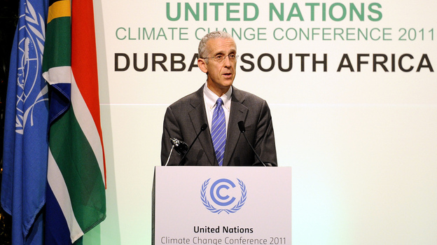
The day of the EarthView Team's return to North Reading Middle School happens to be on the last day of a United Nations meeting in eThikwene, South Africa, better known as Durban. Todd Stern was sent by President Obama to represent the United States at the meeting.


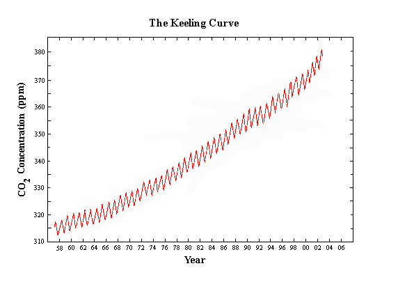
The last major agreement about climate change was made in Kyoto, Japan and is about to end. China and the United States are the two countries that contribute the most gases to climate change, but neither country agreed to the Kyoto Protocol. The meeting in Durban is ending without a new agreement.

The Global Climate Change web page includes links to more resources about the geography of this important problem.

Wednesday, December 7, 2011

Geographic Literacy by 2025

The March 30, 2009 blog post Geographic Literacy by 2025 links to an article about geographic literacy from ArcNews, a GIS magazine from ESRI.

Deepest Mines

A March 30, 2009 blog post entitled Deepest Mines explains the concept of scale and how heat and pressure affect mines.

Friday, December 2, 2011

Advocating for Geography

Since 2007, close to 30,000 Massachusetts students have participated in EarthView programs. The curiosity and enthusiasm of thousands of students and dozens of excellent geography teachers throughout the Commonwealth continue to energize the EarthView team.

Unfortunately, the experience of in-depth geography education is still the exception rather than the rule for Massachusetts students. The Massachusetts Geographic Alliance is a network of geography educators that partners with EarthView and is advocating at both the national and state level for more geographic education and more in-depth preparation of teachers in this crucial area.

Visit the MassGeo blog for the latest information about efforts at both levels, particularly for information about Senate Bill 182.

Andrea Gail

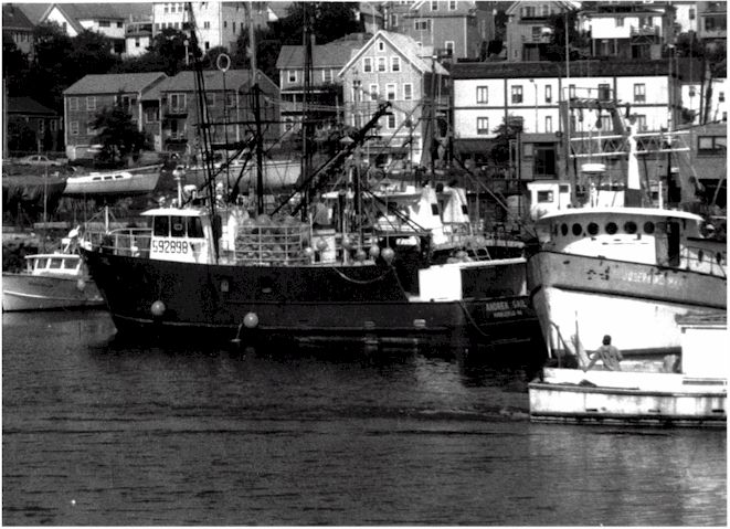
Andrea Gail before the shipwreck, Gloucester Times
The George Clooney film The Perfect Storm was, for many people, the introduction to the perils of commercial saltwater fishing. Coastal communities in Massachusetts are all too familiar with the risks. Even on ships with a multitude of modern technologies -- such as the Andrea Gail -- fishing remains one of the most dangerous professions in the United States.

The tale of how three North Atlantic storms converged was first told in a book of the same name by Sebastian Junger.

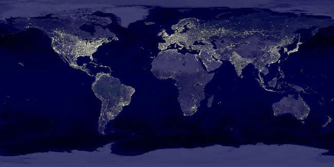
Earth at Night NASA


This is an image mosaic, meaning that many images were "stitched" together to make it. It shows what the earth would like like if we could see it all at once, without cloud cover. Because neither condition is possible, hundreds of images are combined in this single mosaic.

On this image, light is a proxy for population, meaning that it tends to be found in the same places as humans. For this reason, we can see the places where humans live in large numbers and the places that human settlement is more difficult. Generally, the places that do not support agriculture do not support large numbers of humans. Places that are too cold, high, wet, or dry may have human settlement, but at low density. 


Exceptions are often found where some natural resource attracts a population of workers.


Light is not a perfect proxy, though. Notice, for example, that South Korea appears almost as an island, because North Korea is barely visible. Some places with stronger economies look as though they have far more people than they actually do.


Some specific features show up very well on this mosaic. For example, the distribution of population in Egypt exhibits a form not found anywhere else on the planet. 


Visit the APOD page for technical information and a higher-resolution version of the image.

Tuesday, November 29, 2011

Wonders of Nature


The Seven Wonders of the Ancient World are ancient marvels of human ingenuity that were chosen by a handful of individual Greek and Roman writers over a period of several centuries. Several lists were drawn up, all of which included constructed sites in the general vicinity of the Mediterranean Sea (whose name, after all, means, "In the Middle of the Earth").

In 2011, a project endeavored to identify a new Seven Wonders list, this time of natural features and this time chosen more democratically. Steve Curwood of Living on Earth recently interviewed the Eamonn Fitzgerald, who helped lead the effort. The 28 finalists are shown on the map below and described on the finalists page.


The list of Seven Wonders was announced on November 11 and is awaiting final certification. Geography students of all ages can, however, use the original list of finalists to organize their own votes and other educational activities.

For example, using latitude and longitude or a globe, students can identify the finalist locations closest and farthest from home, closest to each other, remotest from each other, farthest north or south, and so on. Finalists can be categorized as biological or geological wonders, or in a variety of other ways. What are the local languages (official and perhaps indigenous) spoken in the vicinity of each? Which are most threatened by human activities and why?

Language and Lands Beyond

The National Public Radio (NPR) program All Things Considered is a daily radio show that includes a lot of different perspectives on news, science, and the arts. Although meant primarily for adults, many middle school and high school students learn a lot -- including a lot of geography -- from the program. It has been archived online for several years, so searching the archives is a good way to find a radio story about almost any area of the world.

On November 29, the program included a lovely story about the 50th anniversary of a children's book that almost did not get published. As many adults now understand, most children love language and wordplay. When author Norton Juster and illustrator Jules Feiffer first offered The Phantom Tollbooth, however, publishers thought it was too sophisticated for children!

The book is known mainly for its fun with language and for the interactions between words and images. In the interview between Michelle Norris and Norton Juster, though, it is clear that this is also a great book for young geographers! Once Milo starts exploring the lands beyond the tollbooth, he cannot help but continue to explore more and more.

Members of the EarthView Team are like young Milo in the story. Among us, we have been to all the towns in Massachusetts, all the counties in New England (one of us has done that individually!), all fifty of the United States, and more than 60 countries around the world. To do this travel, we have learned languages, consulted maps, and sometimes just taken a chance to travel for no reason other than to see what was over the next horizon!

Monday, November 28, 2011

Spofford Pond School, Boxford -- Dec 2

42°41'46"N 
71°01'02"W
(Visit more about Lat/Long for ideas that combine math and geography learning. This is our second visit to Spofford Pond, and it remains the farthest north we have taken EarthView.) 

The town of Boxford is currently involved in an interesting project that will eventually benefit the entire region. According to a recent article in The Tri-Town Transcript (a great name for a local paper!), many people from Boxford turned out for a recent meeting to learn about the section of the Border to Boston Trail that is planned for the eastern portion of the town.

Because team member Dr. Hayes-Bohanan has a lot of friends and former students in South America, the first he heard of the current volcanic activity in Ecuador was in Portuguese! (What country was this former student writing from?)

According to BBC News, the Tungurahua volcano is currently emitting a plume of ash nearly to the top of the troposphere, and schools have been evacuated. So far the activity has not caused any damage, but over the past dozen years, this volcano in the middle of the Andes has been quite active, so authorities are being very cautious. 

Tungurahua is not a Spanish name, by the way. It is of Quichua origin and may simply mean "crater" though the more interesting possibility is that it means "Throat of Fire." The volcano is in a province of the same name, and is located at  1°28′01″S; 78°26′30″W. How does that compare to the location of Spofford Pond School? What is the nearest point in North America with the same longitude as the volcano?

We encourage our Spofford Pond students to use the "Comments" link below to send us their questions or comments about geography.

Our visit takes place on December 2, the anniversary of several events with geographic significance:

1802 The British sold Suriname to the Dutch. (Because he speaks both of these languages, Dr. Domingo was successful as a Fulbright Scholar in Suriname, and is now considered a leading expert on the country.)

1823 President James Monroe Declared the Monroe Doctrine, discouraging European countries from involvement in the Western Hemisphere

1899 The United States and Germany agree to divide Samoa between them; Samoa eventually became independent, but American Samoa is still a U.S. Territory. Look for both of them on EarthView.

1933 Bertil Clason (of Detroit, Michigan) and Sigrid Carlson (of Stockholm, Sweden) married in the first transatlantic wedding officiated by telephone.

And as Spofford School students know -- December 2 is Crazy Hair Day!

Monday, November 14, 2011

Better not Bottled


Most Americans used to get water from the tap. A five-minute cartoon narrated by Annie Leonard, The Story of Bottled Water explains how this changed in one generation. Many Americans now willingly pay $6 to $8 per gallon for their drinking water, generating a half-billion bottles of wasted plastic every week!

As with all of her "Story of Stuff" videos, Leonard does not just complain about a problem. She explains it as part of helping people think about how to solve the problem. This is five minutes of video every person should see!

Saturday, November 12, 2011

Gates Intermediate School, Scituate -- November 18

42° 11' 59" N
70° 45' 18" W
Learn more about Lat/Long

The EarthView team will be making its first visit to Scituate. The name of the town is derived from a Wampanoag word for the "cold brook" that feeds its harbor, but coincidentally sounds like an English word for an important geographic concept!

Because geography is the study of places, geographers are very interested in the many ways in which places can be described, categorized, and compared. Geography distinguishes between two equally important ways of describing places: site and situation. In choosing where to locate a new settlement (or a store or a house or an office), characteristics of the place itself (site) must be balanced with its position relative to other places (situation). The web site of the Barcelona Field Studies Centre lists several examples of site and situation relative to the location of that city. 


What are the site and situation (or scituation) characteristics that led to the settlement of Scituate? What aspects of each continue to make it a popular place to live?


Geography Happenings on November 18 


1993 A record for November cold was set on this date, when the temperature in North Siberia reached negative 55 degrees Celcius (that's negative 67 Farenheit)! Siberia is known for temperature extremes because of its position in the upper-mid latitudes and its continentality. A look from inside EarthView confirms that the interior of Asia is farther from the moderating influence of oceans than is any other place on earth. Incidentally, the radio program On Point recently featured an interview with Ian Frazier about his travels in Siberia, in which he discusses the human and physical geography of this place that is both vast and remote. 
Vladimir Putin in Siberia, AP Photo from WBUR
1987 The Congressional report on the Iran-Contra Affair was released. 


1980 A treaty between El Salvador and Honduras formally ended the so-called Soccer War of 1969, a brief but deadly conflict that had actually lasted only 100 hours. Because soccer is important throughout Latin America, some people assume that soccer was the cause of this war, which it was not. Tensions between the two countries had been building over economic issues, leading to the mistreatment of soccer players during a match, but the real conflict was over the treatment of workers.


1976 Democracy returned to Spain after 37 years of dictatorship.


1961 President Kennedy sent 18,000 soldiers as advisors to Vietnam.


1956 Although it technically became independent of France in March of 1956, November 18 is celebrated as Independence Day in Morocco, when King Mohammed declared independence upon his return from exile.


1941 Mussolini's forces left Ethiopia, in the early days of World War II.


1929 The Atlantic Ocean's largest earthquake broke the transatlantic telephone cable in 28 places.


1909 The United States invaded Nicaragua, later overthrowing President Zalaya.


1902 The Teddy Bear is named for President Teddy Roosevelt.


1883 Time zones are established in the United States and Canada, to simplify train schedules.


1805 Lewis and Clark reach the Pacific Ocean, becoming the first U.S. citizens to cross the continent.


1755 Boston's strongest earthquake occurred, though nobody was injured.


1307 William Tell shoots an apple off his son's head, though it probably did not look like this one!

Monday, October 31, 2011

Brockton UU Church -- October 30

EarthView team members Dr. Domingo and Dr. Hayes-Bohanan were among friends when they visited the Universalist Unitarian Church of Brockton. Several members have participated in other programs of the Massachusetts Geographic Alliance or have seen EarthView in other venues. We were therefore pleased to make EarthView an integral part of the morning's service on October 30, with a program entitled "Our Earth, A Fascinating Place to Be."

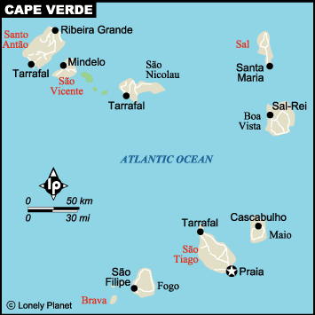
Because EarthView had to be supported above the pews on a platform of dining tables, we had no "inside" program. Still, the two geographers shared a number of insights with the congregation, mainly from the African and Atlantic regions, including Cape Verde, whose eleventh island is sometimes said to be the city of Brockton!

Friday, October 28, 2011

Tantasqua Regional Jr. H.S. -- Oct 28

42° 09' 24" N
72° 07' 44" W

Learn more about Lat/Long


The EarthView team is delighted to be returning to Tantasqua, where the one-and-only Globe Lady, Ms. Rosalie Sokol, first became a geography teacher.

She began life as a French speaker and her education career as a teacher of the French language at Tantasqua. During the 1980s, however, she participated in an intensive training program at National Geographic, and went on to be a geographer extraordinaire! As the Globe Lady, she is part of a team with a passion for geography education that now travels throughout the Commonwealth of Massachusetts.


Our Tantasqua visit occurs on the anniversary of a few interesting events.


1636: Harvard University was founded. Sadly, Harvard closed its geography department in 1948.
1790: Vermont paid New York $30,000 to settle land claims, making way for the 14th state to be formed. It was admitted the next year, on the same day as Kentucky, so that the balance between free and slave states was maintained.
1886: President Grover Cleveland dedicated the Statue of Liberty, a gift from France (which helped establish the USA during the Revolutionary War) and a beacon welcoming people everywhere to this nation of immigrants
1971: John Lennon and Yoko Ono recorded Happy Christmas (War is Over) in New York City. (The links in this line are to two versions of the song that capture the paradox. The first shows Christmas; the second shows children in war.)


When time allows, BSU students who are part of the EarthView team share "extra" lessons about the geography of specific places. In this case, geographer Ashley Costa teaches some samba beats and discusses the cultural geography of Brazilian music with a group of Tantasqua students. Also shown (near bottom-left)  is fellow geographer Brigitta Hart, who had given presentations about Alaska. Both students combined their academic training in geography with their own extensive experience in the regions they discuss. BSU education student Paulo Borges is also available to discuss life in Cape Verde.

The EarthView team can arrange for presentations of this kind to take place in conjunction with any school visit, and are happy to discuss scheduling possibilities ahead of each program.

Monday, October 24, 2011

Congratulations North Andover!

For the past couple of years, the EarthView has been pleased to work with geography teachers at North Andover Middle School. In addition to the daytime program with students, we have also led programs in the evening for parents. 

We have committed to these long days not only because we enjoy the company of the North Andover educators, but also because it enables us to be part of something truly innovative: Family Geography Night! Throughout the building, students and their families participate in a variety of fun, creative, and artistic activities, all of which teach geography and generate interest in learning more.

This year, the State Senate has recognized this achievement and has issued an Official Citation to North Andover Middle School. Family Geography Night is a wonderful model, which the Massachusetts Geographic Alliance and EarthView have started to promote at other schools.

Thursday, October 20, 2011

Collins Middle School, Salem -- Oct 21

42° 30' 52" N
70° 54' 22" W

Learn more about Lat/Long

The EarthView team is very pleased to be visiting Collins Middle School in Salem. Team members Domingo and Hayes-Bohanan attended the annual meeting of the New England and St. Lawrence Valley Geographical Society when it met in Salem in 2009. They and other members of the team enjoy visiting Salem's many historic sites and museums, or simply walking around the beautiful center of the seaside city.

The Collins School is located very close to the most infamous event in Salem's history, and one to which EarthView team member Dr. Hayes-Bohanan has a family connection. His wife and daughter are direct descendants of Rebecca Nurse, one of the victims of the 1692 Witch Trials. Her hanging took place just a few hundred yards from the school, on aptly-named Gallows Hill. Even before we learned of the connection, the story of Rebecca Nurse has been of special interest, and we have appreciated both the educational materials provided by the Salem Witch Museum and the serene Salem Witch Trial Memorial. The stone benches that honor each victim create a serene space in the center of town where people can contemplate the tragedy.

Peter Hutton: FreePort (at PEM)
That tragedy from three centuries ago does not entirely define Salem, of course. Though the city is identified with witches in both serious and light-hearted ways, it is geographically significant in many other ways. These include achievement in the arts and architecture and of course a rich history of seafaring and trade. The delightful Peabody Essex Museum is a great place to learn about Salem, New England, and the world as a whole. Current works include exhibits about container ships, a means of transportation that has really changed the world! 


As always, our orientation to EarthView will also include some discussion of the planet's second-largest continent -- Africa -- which some people mistakenly believe to be a single country, or entirely comprised of "jungle." In reality, Africa is large and diverse in both its physical and human geography.

We are very pleased that the EarthView team will be joined for this and other upcoming visits by Paulo Borges, a graduate student at BSU who will be speaking a bit about his home country. Like many students at BSU, he is from the island country of Cape Verde, located about 400 miles west of the westernmost part of mainland Africa.

Cape Verde is a fascinating country with a very small area but a rich history of connections to the rest of the world. Paulo will tell a little about the environment of his country, and why Cape Verde is much better known south of Boston than it is to the north.

Sunday, October 9, 2011

Upcoming EarthView Events

The following is a partial list of EarthView programs taking place in coming months (revised March 16, 2012). All town and city names are in Massachusetts, unless otherwise indicated. We usually bring EarthView to schools on Fridays; some Fridays are not listed below because tentative arrangements have not yet been finalized or because the team is not available. We are currently accepting requests for remaining openings in spring 2012 reservations and are starting to plan the 2012-2013 season. 

Please see the EarthView web site for requirements and contact information.

For both pedagogic and security reasons, participation at school programs is limited to the students themselves, unless prior arrangements are made for visitors. Certain EarthView events are open to the public, as indicated below.


This schedule will be reposted as further programs are confirmed.

Friday, March 16
CANCELED due to MCAS
Walton Elementary, using Woodville School gym 
Wakefield


Friday, March 23
Wilmington Middle School
Wilmington


Wednesday, March 28 (evening)
South Middle School
Braintree
This is a Geography Family Night program!
On Friday, March 30, the entire EarthView Team will be attending the Massachusetts Geography Bee.


Wednesday, April 11 (evening)
East Middle School
Braintree
This is a Geography Family Night program!


Friday, April 13
The Hood School
North Reading


Friday, April 27
Sharon Middle School

Sharon


Thursday, May 3
Massachusetts State House
Public event: Come see EarthView in Nurses Hall, and invite your legislator to meet you there!


Friday, May 4
Howe Manning School
Middleton


Friday, May 11
Horace Mann Elementary

Franklin


Thursday, May 24 (day)
Bridgewater State University
CONNECT STEM EXPO
Bridgewater


Thursday, May 24 (evening)
Quabbin Regional Middle School
Barre


Friday, June 1
Rumney Marsh Academy
Revere

Friday, October 7, 2011

Photos-North Andover Middle School


North Andover -- Oct 6-7

42° 41' 36" N
71° 07' 15" W
Learn more about Lat/Long (including how to look them up by address)


Photo: Ashley Costa
The EarthView Team -- newly constituted with geography students Ashley Costa and Brigitta Hart -- is in the middle of its fourth visit to North Andover Middle School, to take part in one of the Commonwealth's leading geography programs. See post from December 2010 visit for one of the interesting ways NAMS teachers used EarthView on a previous visit.


In addition to EarthView presentations, the school hosted its annual Geography Night, in which students are joined by their parents, siblings, and other family members get a glimpse of the geography program at this school through games, music, and special appearances -- such as a talk by Channel 5 meteorologist Chris Lambert.

Saturday, October 1, 2011

NASA Image of the Day


Everyone knows that NASA (the National Aeronautics and Space Administration) explores space, but its explorations of the earth are equally important. Fortunately, the Earth Observatory at NASA makes it easy for internet users to get an idea of the variety of ways in which NASA helps scientists, students, and the general public to learn about the earth, through its Image of the Day (IOTD) web site.

Each day, a different image is featured. The images are at a variety of scales, ranging in coverage from a single city or river delta to  a continent to the entire planet or more. Each image is accompanied by a brief explanation, and often by a few more images that complete the story. The sampling above gives an idea of the variety of topics covered by IOTD and by NASA in general.

Users can check the web site each day or subscribe to the IOTD program by email.

Thursday, September 29, 2011

Ahern Return

42° 4' 27" N
71° 14' 18" W

Learn more about Lat/Long


The official postcards of Project EarthView feature a photograph that looks like we took students to outer space somewhere -- really is just the Ahern gym with some photo editing. Of the 30,000 students who have experience EarthView with us, we will have reached close to a thousand at this one school, which we visit for the fourth time this year.


Although we are usually not able to play videos during our school visits, we are going to start featuring on this blog a few videos that we find educational, entertaining and -- above all -- geographic. The first example is The Alphabet of Nations, a peppy song from They Might Be Giants, a rock band that has recorded many quirky educational songs. The song does not list all the countries of the word -- just 24 of them. W and X are left out, to the consternation of those who would include the West Bank.

Friday, September 23, 2011

Braintree East Middle School -- Sept 23

42º 13' 14" N
70º 59' 20" W

Learn more about Lat/Long


The EarthView team is pleased to be returning to the town of Braintree, this time to East Middle School, after a wonderful visit to South Middle School last week.


Braintree is located south of Boston; the name is a bit puzzling, but even odder to newcomers in the region is the phrase "Braintree split," which is not a dessert item, but rather a very important division in the regional highway system. Coming south from Boston, drivers "split" toward Cape Cod or toward the rest of the country, at an often congested intersection in Braintree.


The town of Braintree gets its name from a town in England; we do not yet know the story of how that town got its name or what it means, exactly. Looking to the town seal for a clue, we are still more mystified. This summer, some controversy has surrounded the color of the seal and the shape of the "incorporated" ribbon, but we are still hoping to find out why an arm and sword are featured, and why it looks like someone is swimming with a sword. 


We are hoping that an East Middle School student can provide some clues for us....


Thank Catarina!


The EarthView team is fond of its coffee -- particulary fair-trade, organic coffee that is often brewed by team member Dr. Hayes-Bohanan before a day's outing. In the Hayes-Bohanan household, we think about where our coffee comes from, and whenever someone thanks us for a cup of coffee, we say, "Thank the farmers!" In the case of the coffee the team is traveling on today, we can say, "Thank Catarina" because of a special coffee company called Coffee CSA, which is a coffee company in the United States that is owned cooperatively by coffee farmers all over the world.


Today's coffee was produced by Catarina Yac, a woman in southwest Guatemala who farms coffee on three acres in the region of Santa Clara Laguna. Her farm is located at 15.0848967º N and 91.9227488º W. Noting that these coordinates are in decimal (rather than degree-minute-second) form, we can use them to find out how far the coffee is from its farm today.


Try answering the following questions about Catarina's coffee:


1. How big is her farm, compared to the East Middle School campus?
2. How many degrees of latitude is East Middle from her farm? What direction?
3. How many degrees longitude is East Middle from her farm? What direction?
4. How many miles or kilometers away is the farm?
5. How far is the farm from the nearest road (see the Google Maps link on Catarina's web page)? The nearest city? The Pacific Ocean?

Thursday, September 22, 2011

EarthView on International Day of Peace

Thirty years ago, the nations of the world -- through the United Nations General Assembly -- voted to designate September 21 of each year as the International Day of Peace. For the past seven years, the day has been celebrated in EarthView's home base of Bridgewater. The recognition of the day has included religious and educational organizations in vigils, parades, concerts, and the annual rededication of a multi-lingual Peace Pole near the center of the town.

The pole is located between the First Parish Church (41° 59' 18" N; 70° 58' 26" W) and the University campus, and carries the message "May Peace Prevail on Earth" in about a dozen languages, each chosen because of particular connection to the community and region. Native speakers of the languages often assist in the ceremony.


Since the Geography Department at Bridgewater State University (then College) acquired EarthView in 2008, the giant globe has also been part of the festivities, being placed on a platform above the pews in the enormous and historic sanctuary of First Parish Church, Unitarian-Universalist. People marveled at the globe, which was a tremendous reminder of the importance of cooperation on a planet that all humans share and of the fact that the planet did not originally come with political boundaries. Dr. Domingo and Dr. Hayes-Bohanan were often on hand to answer questions about EarthView and the planet itself. Dr. Hayes-Bohanan even spent an entire night under EarthView's shadow!
Photo: Tony Esposito
Many visitors expressed a desire, however, to enter EarthView, which after all was designed specifically for this purpose. The entire EarthView Team therefore worked with the Peace Celebration Committee to set up EarthView as part of a five-day series of events. On Wednesday morning, therefore, the actual day designated by the United Nations, EarthView was set up in the Kelly Gym at BSU for the general public to view it, and even to enter it. Several university staff members who had not previously seen EarthView were delighted to have the opportunity, as were about a dozen students in a local home-schooling network.

Track the 50/50 team.
EarthView also had a very special visit from the three remarkable members of Project 50/50, who have dedicated themselves to a lives of full-time service to others. Each week, the team visits a different state of the U.S. to raise awareness of local human needs, and to assist directly in addressing those needs. In this way, Shay, Shane, Rob, and their border collie Zuzu are learning geography every day, and putting that learning to use in the service of others.