EarthView team bios, guidelines, and more.

Friday, December 21, 2012

Apocalypse Not

"Tonight I'm gonna party like it's 

baktun 12 katun 19 tun 19 uinal 17 kin 19 Haab: 2 Kankin Tzolkin: 3 Cauac"

This winter's solstice coincides with the beginning of 2 baktun


I remember once pulling into a friend's driveway to take a photo when the odometer had turned over on our car. The car was no different on the way home than it had been earlier in the drive, but we stopped to mark the occasion. Similarly, we tend to celebrate our birthdays and anniversaries more if they are "major" -- 10 is a bigger deal than 9 or 12, and 100 is a really big deal. 

The mislabeled "Mayan Apocalypse" was simply a notable turnover of the "odometer" in an unfamiliar calendar system. It is a coincidence that the digits of today's date form an interesting pattern using a Gregorian calendar (what we use in the United States), just as they require an extra digit in the Mayan calendar. 

The opening line above is an allusion to the song "Party Like It's 1999," which the musician Prince released in 1982. At that time, New Year's Eve of 1999 seemed like a significant "odometer moment," and also seemed to be very far in the future!


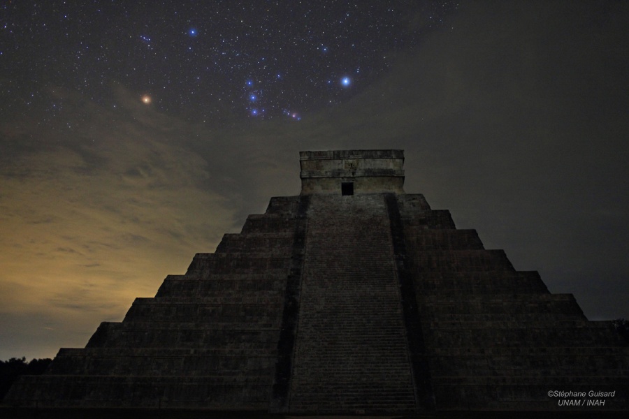
The NASA Astronomy Picture of the Day celebrates today's solstice and the flurry of attention to Mayan math and astronomy. Thanks to EarthView's administrative team member and former NASA scientist Dr. Diana Jennings for sharing this image. 

Astronomy, by the way, is related in many ways to physical geography. People of all ages are welcome to learn about astronomy at the new Bridgewater State University Observatory, which offers many public viewing nights and other programs. Both the Observatory and EarthView will soon be part of the university's Center for the Advancement of Science Education, which brings together all of the university's exciting outreach programs in science.


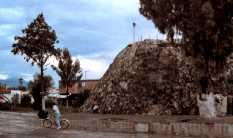
The Doonesbury comic for December 21 is timely and a bit cute. It gives the mistaken impression that Mayans are no longer present. Although not organized into a hierarchical society as they were when the Spanish arrived, Mayans are still found throughout the Yucatan and neighboring areas of Mexico and Central America.

In fact, Pam and James Hayes-Bohanan will be teaching about historic Mayans while working with contemporary Mayans in a college-level course next year, to be taught in Belize. It is called Maya Gold: The Geography and History of Chocolate in Belize!

Monday, December 10, 2012

Population Primer

Our friends at geography.about.com recently posted reposted an article about the growth of the world's population over the past twenty centuries and to the end of the current one. (The article also has a lot of links to other useful articles about population.) I quickly copied the numbers into Excel to make the following simple graph.
Viewed from Year 1 (A.D. or C.E. -- Current Era) until 2083, population takes the form of the letter J, or perhaps a hockey stick. That is, it grew very gradually for 1800 years (and for about 8,000 years before that), and really grew significantly only in the past century or two. The population has more than doubled, in fact, since the members of the EarthView team were born. This is not true of the Wranglers who are still in college, though the planet now has almost 2 billion people on it than when they were born!

A J-curve represents exponential growth, which shows no sign of stopping. A more careful look at these numbers, however, reveals that the growth is actually not shaped like a J. By graphing the data only since 1804, a subtle but important shift in the pattern can be more easily seen.
These are the same numbers, except that the earlier, long period of very slow growth has been removed. Rather than a J, the growth resembles an S, which is why this pattern is called sigmoidal, after sigma, which is the Greek letter equivalent of S.

This kind of growth occurs with many living things, including humans. Rapid growth often occurs when resources are abundant, and then slows as resources become scarcer. What looks like unstoppable growth slows down when limitations are reached.

In the case of humans, agriculture allows for significant growth, but industrialization allows for growth that is much more rapid, at least initially. Many regions have experienced what geographers call a demographic transition, as the rapid growth eventually slows. As explained on the BBC "Bitesize" article on population change and structure, these changes do not result from rising birth rates, but rather from falling death rates.

Most of the world's industrial countries -- such as the United Kingdom, the United States, Italy, and Japan --
have been through some version of the demographic transition and now have relatively slow growth, or even negative growth. Many developing countries -- such as Mexico and Brazil -- are near the end of such a transition. Most importantly, even in countries where population growth rates remain high -- such as Kenya and Jordan -- the transition is beginning, and growth is beginning to slow. (See the Census Bureau International Database detailed estimates of population change in these and all other countries.)

CLICK to ENLARGE
Mexico's current population pyramid shows that the country's population has
 been growing in recent generations, but that growth in the future
will be slower. This kind of graph is more properly called an
age-structure diagram because not all countries resemble pyramids.
The Census IDB generates diagrams for individual countries by year.
National Geographic provides a
 lesson on making andinterpreting the diagrams.
The result is that although human population is expected to grow by an additional 3 billion people before this century is ended, it is not expected to grow much beyond that.

For geographers and other scientists who are concerned about the demands a growing population places on natural resources, it is encouraging to see that the growth of population is slowing down. Biologist E.O. Wilson has described this curve as a "bottleneck" because it shows a period of rapid growth that is lasting for only a couple of centuries. For a long time before and after this period, human population growth was and will be very slow. Most of the plants, animals, and resources that survive this rapid change are likely to survive long-term, but survival during this period requires a lot of care and protection.


Saturday, December 8, 2012

Volcano Roundup

When speaking yesterday with North Reading students about my 1989 visit to the world's smallest volcano, one student asked about the world's largest volcano. By a variety of measures, Mauna Loa holds this distinction. It rises 13,677 feet above sea level, which is surpassed by many volcanoes, but nearly 30,000 feet from the sea floor, and 56,000 feet (eleven miles!) from its base within the ocean crust. It is so massive that the crust dips more deeply into the mantle below it. Mauna Loa is also a fairly active volcano, with 33 documented eruptions since 1843.


View Larger Map

Although located in the middle of the Pacific Ring of Fire, Mauna Loa is not part of the Ring of Fire. Rather, it is a hot spot volcano, similar to those that have formed Iceland and Cape Verde. Such volcanoes form in the middle of ocean plates, as they pass over hot spots deep in the earth. If the spot alternately hot and cool, the result can be a line or arc of separate volcanoes, with the most recent activity at one end of a long line of older volcanoes.


View Larger Map

More than three quarters of the world's 15,000 active volcanoes are found along the edges of the Pacific Ocean, where convergence between oceanic and continental plates results in both earthquakes and volcanic eruptions. (Fourteen of these are in Nicaragua, including the recently -- and beautifully -- erupting San Cristóbal.)

By some measures, the Yellowstone volcano is much larger, and is also considered active. A catastrophic eruption is theoretically possible, but the risks are considered remote by park officials.

When measured in terms of elevation above sea level, Mauna Loa is not even close to the top-ten list, all of which are Pacific-Rim volcanoes in the Andes of South America. The tallest volcano in the solar system, by the way, is a basaltic shield volcano on Mars. Olympus Mons towers more than 85,000 feet above the surface, with a base about the size of New York -- the state, not the city!

During our visit to North Reading, we also discussed some of the beautiful volcanic craters that had just been listed on the web site World Geography the day before. The first of these is Diamond Head, which is on the Hawaiian island of Oahu. The page lists a total of ten craters, each of which has a unique form that results from the volcanic events that created it, erosion and human activity since its creation, and climatic factors. The story of each is included, with a link to further information and an interactive map.
 Top-Ten List of Craters from World Geography
Seeing such fantastic images reminds us of other volcanic craters and calderas we have visited or hoped to visit. One of my favorites is Lake Atitlan in Guatemala, where I visited coffee farmers in 2008. A friend with whom I shared the Diamond Head photo told me that he had climbed the outer edge (it is very steep!) and had also visited the nearby Punchbowl/Puowaina crater, which has been both an ancient and a modern burial ground.

The United States Geological Survey is a good source of detailed  information about volcanoes in the United States and earthquakes worldwide. Its web site includes nearly instantaneous mapping of earthquakes, wherever in the world they may occur. The main USGS employs many geographers -- along with other scientists -- engaged in mapping and studying biological, water, mineral, and other natural resources.

Monday, December 3, 2012

North Reading Middle School - December 7

42° 34' 36" N
71° 05' 17" W

Learn more about Lat/Long

The EarthView team has visited North Reading several times. The most recent visit was almost exactly a year ago, on the last day of important climate-change meetings in South Africa. Similarly, this year's major climate-change meeting is ending on the day of our visit. It is being held in Doha, Qatar.

Qatar is a small country that emits three times as much carbon per person as the United States; in fact, it has the highest carbon emissions rate in the world. Qatar allowed its first-ever legal protests by visitors who objected to the contrast.

Protesters in Doha; image from Gulf Business
December 7 is also, of course, the "day that will live in infamy," according to President Franklin Roosevelt, as it was the 1941 date of the attack on Pearl Harbor that drew the United States into World War II. That single event was the beginning of many profound changes in the political and economic geography of the entire world.

Pearl Harbor was struck by planes flying from a nearby aircraft carrier. In 1966, the U.S. Government Printing Office produced maps that showed the path that had brought the carrier close to the island, and its route back to Japan.

Image: WikiMedia

Tuesday, November 27, 2012

East Middle School, Braintree -- Nov. 30


42°13'15"N 
70°59'23"W
(Learn more about Lat/Long, including how to look up by address

The EarthView team has enjoyed frequent visits to both East and South Middle Schools in Braintree, both for school-day programs and for evening Family Geography Night programs. We find a lot of interest in geography among students, teachers, parents, and administrators at both schools, and enjoy finding out what is currently being studied each time we visit.

During a visit to South Middle School a fortnight ago, we challenged Mr. Henry and his students to develop some activities relating to the latitude and longitude of the two schools. Mr. Henry was part of the first group of teachers to be trained in our EarthView Institute, so we know that even if the holiday has not allowed enough time to respond to our challenge (see the blog post for our November 16 visit), something interesting will come of it soon.

During our visit this week, we will find the location of one of the most interesting geography stories of the week -- the disappearing island of the Coral Sea! We first heard the story of this island on The World from Public Radio International, in a report called An Island That Isn't All There (we recommend reading and listening to the story).

1952 Italian map showing Sandy Island
PRI's The World
The island has appeared on maps for more than two centuries, but although a sea mountain makes the ocean somewhat shallower than the surrounding ocean floor (1400 meters), it cannot have been an island in historic times. The source of the error is not yet understood, but librarians at the Auckland Museum have been able to show find some very early references, which they report on the museum blog.

Apparently unsure what to do with such an unusual cartographic error, Google Maps currently shows the location as something like a virtual hole in the map -- as of the time of this writing, soon after the undiscovery.

Thursday, November 15, 2012

South Middle School, Braintree -- November 16


42°11'02"N 
70°59'53"W
(Learn more about Lat/Long


Throughout several years of the EarthView program, we have enjoyed several visits to South Middle School and East Middle School in Braintree, and are happy to be returning to both this month, starting with South. (Click on the EarthView Braintree search to see all of the blog posts about our visits, which include information about the geography of Braintree itself.) We enjoy these schools because of the great geography teachers and creative geography students, plus the support that geography receives from the families and school administrators. It is great to have two schools working together to learn geography.

We hope to help by seeing how many activities the geography students and teachers can do using our EarthView Experience map and the coordinates of the two schools. For example, what is located exactly halfway between the two schools? How far apart are the schools, based on the coordinates, the "ruler" in Google Maps, and various routes between the two? How far apart are they in time? What is on the opposite side of the earth from each?

The proverbial gauntlet has been thrown down. We will post a report from the two schools after we visit East Middle in a fortnight. Meanwhile, here are those coordinates:

42º 13' 14" N
70º 59' 20" W


View EarthView Experience in a larger map

Hurricane Sandy (see recent posts for some of the geography of the storm) had a geographic impact that some area birdwatchers were watching for. A number of birds, most notably the Northern Lapwing, was carried by the storm far from its usual range.


This member of the plover family was sighted in various places from Cape Cod to Middleborough and Halifax, Massachusetts. It is normally found only in Eurasia, as shown below. It spends summers and breeding seasons toward in northern parts of its range (shown yellow), with winters spent to the south (shown blue). It is resident in much of Europe, meaning that it is found year-round in these areas (shown green).

From WikiMedia -- click to enlarge

Monday, November 12, 2012

Spellman Museum, Weston -- November 12

42° 20' 55" N

71° 18' 26" W

Learn more about Lat/Long

(UPDATE: See photos from the visit below.)

EarthView is part of a public event at the Spellman Museum of Stamps and Postal History, which is located on the campus of Regis College in Weston. In fact, since the museum does not have high ceilings, the college is sharing its field house for the morning.


View Larger Map
The stamp museum and geographers have been working together for many years, because stamps are not only fun, they are geographic! Stamps are tiny snapshots of the cultural geography of places, and they also represent the connections between places. Read more about geography and the Spellman Museum in our February article.

EarthView team member Dr. Hayes-Bohanan has had several reasons to be a fan of the Spellman Museum since learning about it a few years ago. First of all, he attended a workshop on using stamps in teaching, which he calls "stamp camp." Second, he knows that the museum does a lot of fun and educational programs for people of all ages. Finally, he learned that the museum was dedicated by Cardinal Spellman on the day he (Dr. Hayes-Bohanan) was born!

Students at Foxborough Regional Charter School display some
of their 1.5 million stamps.
Our first visit takes place on Veteran's Day (as observed), which is also known as Remembrance Day. This weekend also marks the anniversary of Kristallnacht, a pogrom early in the history of the Holocaust. Students at Foxborough Regional Charter School have been studying this terrible history, and collecting postage stamps to represent the eleven million people who were killed. After four years of collecting, this project reached a milestone of 1.5 million stamps this weekend, representing all of the children who were victims. The project was described in a Boston Globe article, and is similar to the project described in the excellent documentary film Paper Clips.

Photos from the Visit

EarthView's visit to Spellman Museum was quite a success. The museum staff publicized the event and organized the visitors, and provided stamp activities that complemented the EarthView program beautifully. A steady stream of visitors enjoyed EarthView -- and the stamps -- throughout the morning. The athletic and facilities staff at Regis College graciously provided access to the college gym, which was an excellent venue.

Photographer, geographer, and former EarthView Wrangler Ashley Costa accompanied Drs. Hayes-Bohanan and Domingo for the Spellman Museum outing. Some of her photos are posted below; the rest will be on Flickr soon.

Stamps convey many geography lessons, including flag identification.
Participants were able to choose from among thousands of stamps
in making their own world maps.
Visitors placed stamps on blank maps of the world, using place-mat maps
as a guide for finding unfamiliar countries.
The EarthView team enjoyed the scores of visitors, from infants and
toddlers through primary, secondary, and college students.
Visitors also included very knowledgeable philatelists -- some of whom
have been collecting stamps for decades -- who shared some
geography lessons of their own. 
The EarthView team is certainly looking forward to its next visit to the Spellman Museum. Meanwhile, we encourage everyone to visit the Spellman Museum -- even on days when it does not have a giant globe -- for a unique way to learn geography!

Many more of Ashley Costa's photos from the day are in the Spellman-EarthView 2012 photoset on Flickr. Quite a few of these photos were taken from inside Earthview, so identifying some of the locations is a fun challenge.

Wednesday, November 7, 2012

Mashpee Middle School -- Nov. 9


41° 36' 57" N70° 30' 34" W

Learn more about Lat/Long


We are glad to be learning to the really big gymnasium at Mashpee Middle School, which we last visited in March of 2011. Please see the post from our previous visit for some interesting information about this unique town.

The town of Mashpee makes it convenient for residents to explore their community through an online Geographic Information System (GIS) hosted by Maps Online. The screenshot below shows the area surrounding the school itself, with identified wildlife habitat, vernal pools, and elevation contours featured. Viewers can examine other features of interest throughout the town and at a variety of scales.

Click to enlarge or make your own map at
Mashpee Maps Online

People throughout the world have been paying attention to the geography of the United States, because our presidential elections are decided by the Electoral College. Every major news organization made interactive maps available, such as this map from the New York Times, which is accompanied by maps for Senate and House seats as well.

As we all know, the entire Northeast region was recently affected by a major storm. In an earlier post, we described some of the geography related to forecasting for Hurricane Sandy. It became known as Super Storm Sandy because it was "only" a Category One hurricane, but was unusually large and arrived at the same time as a mid-latitude nor'easter storm.
October 28 image as shown by UK Telegraph.
The damage to utilities and transportation was immense, and many of us know people who are still without basic services in their homes in New Jersey, New York, and Connecticut. A second storm this week made recovery even more difficult. The experience is bringing renewed attention to ideas that geographers and other scientists are proposing for adaptation to the effects of climate change. The sea gate shown below, for example, is one of five ideas for preventing flooding in New York. These and other ideas -- some of which would only work for major cities -- were discussed yesterday on the On Point radio program.


Meanwhile, planning and geography professionals in New York - a bit upriver from the City -- have created Revitalizing Hudson Riverfronts. It is both a book published in 2010 and a series of workshops and meetings to help communities prepare for rising water and other consequences of climate change. The next meeting is next week, and it is certain to get a lot of attention!

Thursday, November 1, 2012

Burkland & Goode Elementary Schools -- November 2

Burkland
41° 53' 14"  N
70° 54' 42"  W
Goode
41° 53' 12" N
70° 54' 36" W
Learn more about Latitude and Longitude (including how to find them by address)

EarthView returned to the Henry Burkland and Mary Goode Elementary Schools in Middleboro, where one of our wranglers attended as a student!

We always enjoy visiting these schools (which are adjacent to each other), and this time we will have two special events for the afternoon classes. First, film students from Middleboro High School will be filming EarthView as part of a short video about geography. Second, students from Manchester Metropolitan University (MMU) in England visited some of the classes and participated in recording the video.

The MMU students are at Bridgewater State University this year as one of BSU's many exchange programs.

During our visit, one of the second graders asked us about the size of Madagascar, which we were able to look up on the CIA Factbook, a very useful reference work that is actually available for download. To answer his question, the island nation of Madagascar covers 587,000 square kilometers, almost twice the size of the state of Arizona.

MMU students joined the Wranglers for part of the afternoon.
Students from the video production class at Middleborough High School made a brief documentary about our visit.

EarthView at H.B.B. from MET on Vimeo.

Friday, October 26, 2012

Tracking Sandy


REVISED Monday, October 29, 9 a.m.

The National Hurricane Center is the best source of information for the expected paths of tropical storms, including hurricanes. The 5-day Forecast Cone for any active storm shows the most likely path, the expected intensity, and the spatial range of likely paths. It is called a  "cone forecast" because the predicted paths for the first day or two are narrow, widening further into the future.

MONDAY MORNING NOTE: We have updated this post about twice each day since last Thursday, in order to document the changing forecasts of Hurricane Sandy. As of Monday morning, the storm has not yet made landfall, and its exact path remains uncertain and very unusual as it interacts with other storms. The National Hurricane Center cautions that the exact location of the center is not very important as this is a very wide and slow storm, with the highest winds not necessarily near the center.

The cones are revised as geographers and meteorologists learn more about the behavior of each storm over time. Compare the forecast cone from Thursday afternoon ...


with the cone generated Friday morning ...


and with this cone Friday evening:

By Saturday morning, the cone had narrowed somewhat over water, as the range of estimates for the location of the storm's landfall also became narrower. Notice that landward side of the cone remains fairly wide, because it remains difficult to predict how the storm will interact with a northern, jet-stream storm that has forecasters quite concerned..


By Sunday morning, the possible ranges of Sandy's path had narrowed, and it had become apparent that it will turn northward after weakening near the center of Pennsylvania. It is also likely to maintain tropical-storm strength into Friday, a bit longer than had been expected.


As of Sunday evening, the storm had moved northward, and its path was expected to turn further toward the east, with the possibility of turning  directly into New England late in the week.


By Monday morning, the northern portion of the storm was affecting Massacusetts, though the center was still hundreds of miles to the south. The storm was expected to slow even further, tracking somewhere into northern New England or southeastern Canada in the early hours of Saturday.

These and other graphics generated by the National Hurricane Center are created with the use of very strong geographic and cartographic skills. For example, the following map indicates the expected probability of winds at tropical-storm strength being observed at some time during a 120-hour period. Similar maps can be viewed for expected precipitation.


In turn, information from the NHC is combined with other kinds of geographic information as people in many kinds of organizations make geographic decisions as they prepare for the storm. Retail companies such as grocery and hardware stores are making important decisions about the trucks that are moving from all over the United States toward the areas that are expected to be affected. How much material should they send? Where should they send it? When? Are there safe places near the storm where supplies should be sent temporarily? All of these are complex, geographic questions with very important consequences.

Thursday, October 25, 2012

Getting Around


More than 110,000 people have used EarthView since we began the project in 2007. Recently, we began working on EarthView Experience, a Google Map that provides two kinds of information. First, it shows where EarthView has been (purple pins) or is scheduled to go soon (yellow pins). Most but not all of  these locations are in Massachusetts.

The other purpose of this new map is to give some idea of where members of the EarthView team have lived or traveled, with just a few examples from each of the states or countries we have been to. Collectively, we have been to all 50 states and more than 50 other countries.


View EarthView Experience in a larger map

El Volcán Más Pequeño del Mundo

Popocatepetl as seen from Cholula. Clearly, this is
not the world's smalllest volcano!
Image from Nicho blog post about this amazing volcano.
A great part of Project EarthView is the questions students ask us about geography. At North Andover Middle School today, a student asked a question that took me (Dr. Hayes-Boh) back to one of the most enjoyable trips of my life (so far).

After learning about the recent eruption of San Cristobal in Nicaragua, a student asked, "What is the smallest volcano in the world?" It sounds like a difficult question to answer, because the "smallest" of anything tend to be much less known than the largest. In this case, though, I happened to know the answer right away -- though I confess I had forgotten the Nahuatl name for it.

As we prepared for our 1989 visit to central Mexico, my wife Pamela and I had read that Puebla -- the city where we would be spending the summer -- contains "El Volcán Más Pequeño del Mundo." As we entered the city we saw the enormous Popocatepetl and Itzatccihuatl, and thought the smallest volcano must be nearby.

Photo: Pam Hayes-Bohanan
A few days later, we were atop the pyramids in Cholula (shown above, it was the tallest structure in North America in 1491) when we asked a local friend -- who is still a friend -- where the world's smallest volcano was. "Oh," he laughed, "you can't see it from here. It is really small! But it is near my house, so you should come for dinner and I'll show you."

When we went to his house, I kept straining to see the volcano, and was wondering how people could be so sure they had found the smallest one. And then we stepped around a corner and there was Cuexcomate -- and its world-record status was obvious! Pam documented our Cuexcomate visit and other memorable parts of that summer, and Geo-Mexico provides a lot of details about this unique volcano.


View Larger Map

OTHER QUESTIONS: To other recent questions from students, we would like to offer some brief answers. The Seven Summits (or Seven Peaks) are the highest mountain summits on each of the seven continents (where all of Oceania is considered a continent, rather than Australia). As described on Geography at About.com, the term Seven Seas has at least three meanings. It can refer to a life spent on seas in general, to seven particular seas of particular importance in the early history of Europe and southwest Asia, or to today's seven major ocean basins.

Mystery Solved


Neckties are among the favorite props of the EarthView team. When the EarthView program began, Professors Domingo and Hayes-Bohanan each grabbed a favorite flag tie, and continued to wear them to most EarthView appearances.

Although we are geographers, our knowledge of vexillology is not complete (nor is our knowledge of geography, of course). So we were sometimes stumped when students asked us what countries are represented by particular flags on each tie. Recently, we created online quizzes for each tie (see Domingo tie and Hayes-Bohanan tie), both to help students and to make sure we would know all the flags. Most of the flags were easy to identify on lists of national flags, but the flag shown above did not appear on any such list.

It is difficult to search images without any descriptive words, so we put the question of this flag's identity to geographer Matt Rosenberg, who manages the popular Geography page on About.com. He in turn sent the question out through his social networks, and quickly learned that this is the flag of Sint Maarten.

Sint Maarten is a constituent country within the kingdom of the Netherlands. It shares the Lesser Antilles island of Saint Martin with the French overseas collectivity that is known at Saint-Martin.

During our recent visit to North Andover Middle School, some students asked where these ties could be purchased. Even though my tie (Dr. Hayes-Boh) was purchased long ago, it is still available at the Tie Store, as is another world flag tie in a different design  .


Saint Martin (the island shared by Saint-Martin and Sint Maarten) is among the northernmost of the Lesser Antilles, an arc of islands to the east of the Caribbean Sea. It is located just to the south of Anguilla. Because of the small size of the islands and the relatively great distance among them, panning and zooming in the map below is a good way to learn the spatial relationships in the Lesser Antilles.


View Larger Map

Wednesday, October 24, 2012

North Andover Middle School -- October 25-26

42° 41' 36" N
71° 07' 15" W
Learn more about Lat/Long (including how to look them up by address)

North Andover Middle School has become EarthView's second home, hosting EarthView more than any other school and really helping to boost geography awareness throughout the North Shore. Excellent preparation of NAMS students throughout the year combines with the wildly successful Geography Family Night to make this school both special and especially spatial!

Not only has NAMS Family Geography Night earned special recognition from the Massachusetts Senate, but a five-minute video produced at NAMS last year is also used as part of EarthView's advocacy and outreach statewide.
During our visit, we look forward to meeting many family members and to taking the time to explore the world NAMD students. We will also be encouraging students to think about other ways to explore geography, such as the Mapparium in Boston's Back Bay and the Spellman Museum of Stamps and Postal History in Weston.

We will also suggest online games (see the permanent link on this blog), especially the game about Dr. Hayes-Bohanan's tie and the Nicaragua volcano game. (BSU geography students visit two of Nicaragua's fourteen active volcanoes every winter.) New: We have a game for Dr. Domingo's tie as well. See the "mystery solved" for follow-up information about these ties.


A student wearing a t-shirt from "I'm Just A Bill" reminds us of all the time EarthView and its team members have spent in the Massachusetts Legislature in recent years, introducing and promoting a bill to further geography education in the Commonwealth.

Monday, October 22, 2012

Port Cities


Photo by Amanda Valente, BSU

During our visits to the Burkland and Goode schools in Middleborough, we have been very impressed with the murals, including one depicting the importance of maritime connections in our region. This kind of public art is common in communities directly adjacent to the sea, but all the more important in places like Middleborough and Bridgewater, which are just far enough away that the connections might be forgotten.

For example, where the Taunton River divides the two towns, the Titticut area still bears the marks of an old shipyard, where tall ships were launched for use crossing the Atlantic Ocean. It has been many years since such a thing could be done so far upstream for three reasons. First, many bridges would block the progress of the ships. Second, the dam in Dighton would also be in the way. Third, and perhaps most important, Bridgewater and Middleborough no longer have white pines of sufficient size to make the masts of ships.

Nonetheless, both Middleborough and Bridgewater remain connected to the sea, through the connections of both towns to active seaports to the north and south -- Boston and New Bedford. Just after we noticed mural depicting earlier maritime activity in Plymouth -- whose historic port remains a great area to visit and learn -- we noticed a special article on port cities by our friends at Geography@about.com.

Sunday, October 21, 2012

Farmington, Maine -- October 19


N 44° 40' 08"  W 70° 08' 53"
Learn more about Lat/Long (including how to look them up by address)

EarthView has never been closer to the North Pole than it was for our visit to the University of Maine-Farmington on October 19, but it has still not reached the half-way point. (Classroom exercise: How much farther north would EarthView need to go, to be halfway between the equator and the north pole?)

As the EarthView Experience map shows, our primary mission is to serve students in Massachusetts, but EarthView is also dedicated to promoting geography wherever the opportunity presents itself, and the annual meeting of NESTVAL was indeed a special opportunity. The meeting is hosted each autumn by a college or university geography department in New England or the St. Lawrence Valley of Canada.


For this visit, the EarthView team included Drs. Domingo and Hayes-Bohanan and seven geography majors from Bridgewater State University who were at the meeting to learn more about geography and to compete in a region-wide World Geography Bowl. Some members of the BSU team may be going on to national competition next April.

The athletic department at UMF graciously allowed for our use of the gym all day, and the UMF geography faculty and students worked with the Maine Geographic Alliance to organize visitors and provide lunch for our crew. Visitors included UMF undergraduate education majors, local students from preschool through elementary school, and participants in a diversity conference that was taking place at UMF the same day.

See more photos from EarthView at Farmington on Flickr.

Tuesday, October 9, 2012

My Tie Geography

Many of the students participating in EarthView enjoy the flag ties that Dr. Domingo and Dr. Hayes-Bohanan often wear to the programs. Each contains a different, random assortment of national flags.

Those who are curious about the flags can now examine this segment from Dr. Hayes-Bohanan's tie, and compare it to a list of all the world's national flags for a quick lesson in vexillology.

(UPDATE: We had not been able to identify the flag in the bottom row, next to the Brazilian flag. It is somewhat similar to the flag of the Philippines, but not exactly. We eventually learned that it is the flag of Sint Maarten, which is a territory, rather than a country.)

To assist in learning these flags, see the "Dr. Hayes-Boh's Tie" quiz, the newest of several specialized geography quizzes he has created on the site.

To learn more national ties, see the flag quizzes on JetPunk. Notice the link near the top of the page, to quizzes at three levels of difficulty.

The GeoGames page has links to many more fun ways to learn geography, for many levels of difficulty and different learning styles.

Many EarthView participants express interest in purchasing our ties. We are not in the tie-selling business, of course, but we have found a source for Dr. Hayes-Boh's tie (which he purchased long ago at the Miami International Airport). It is available at The Tie Store, as is another world flag tie in a different design.

Thursday, October 4, 2012

Burkland and Goode Schools, Middleboro -- October 5


Henry B. Burkland: N 41° 53' 12"  W 70° 54' 37"
Mary K. Goode:      N 41° 53' 14"  W 70° 54' 42"
Learn more about Lat/Long (including how to look them up by address)

This is our second visit to the Burkland and Goode Schools. Please see the blog post from our January 2012 visit for some fun questions about the coordinates of these schools compared to each other and compared to EarthView's home base in Bridgewater.


View EarthView Experience in a larger map

Satellite images and online maps are a big part of modern geography science, and we are using them to keep track of where we have taken EarthView. The Middleboro section of our new EarthView Experience map shows three schools we have visited in the town. Without zooming in, can you tell which one is Burkland and which is Goode? What is the third marker a bit to the southeast?

We are very fortunate to have a geographer from Middleboro as one of our new EarthView Wranglers (the BSU students who help us with the EarthView program). Macee had a few interesting things to share with us about Middleboro (or Middleborough -- that's another story). She reminds us that this is the second largest town in Massachusetts (by area). What nearby town is even larger?

Macee provided this map, which includes a clue. Middleboro is highlighted, as is all of Plymouth County.


Macee also told us about the geography of the Burkland and Goode Schools themselves. Students used to progress from Goode (Grades 1 and 2) to Burkland (grades 3, 4, and 5), but now students are assigned according to the town geography, with every street assigned to one of the schools. Without a map it is not easy to see, but the Burkland streets and the Goode streets seem to be in the north and south parts of the town. We hope that some Burkland and Goode students can figure this out and use the "comments" button below to let us know for certain!

Buildings are an important part of the human geography of any town, and they change over time. Macee provided this photo of Main Street -- you can click to enlarge it. Notice that it has trolley tracks in the middle of the street. What other clues can you find to the age of the photograph. Can you find this location today? (Please don't stand in the middle of the street to find it, but perhaps you can come close to it.) Can you or your parents figure out which buildings are still in place and which have changed? What kinds of businesses might no longer be as important? What kinds of businesses would you find on Main Street today that  would not be found when this picture was made?

Did you know that Middleboro was once covered with ice, perhaps a mile thick? And as most of the ice melted, some huge chunks remained, and flowing water deposited a lot of sand, gravel, silt, and clay around them. These deposits became much of the land of Middleboro and the giant ice cubes eventually melted away, leaving holes for ponds. Some of those kettle ponds remain; others filled in with organic matter and became the perfect places to grow cranberries. This is one reason that Middleboro and neighboring towns became the world's most important cranberry producers.

The headquarters of Ocean Spray is located in Middleboro, at a site that was chosen with the help of a geography professor from Bridgewater State who passed away about ten years ago. Look at the map that shows the headquarters, and see if you can figure out why the site was chosen.


View Larger Map

One final piece of Middleboro geography is the Oliver Mill Herring Run, which was part of a field trip for university geography students this summer. Herring are anadromous fish that migrate from the ocean to their birthplaces in small streams. They are historically very important to the New England diet, but when industry grew in this area, the factories (mills) often interfered with the fish. More conscientious builders created fish ladders, which remain in use today, even after the factories are gone.
Photo by BSU Geography student
Ashley Costa (c) 2012.