EarthView team bios, guidelines, and more.
Showing posts sorted by relevance for query brazil. Sort by date Show all posts

Saturday, June 8, 2013

World Cup 2014

Throughout the 2013-2014 school year, look for more information about the geography of football, which is known as "soccer" in the United States. In June and July 2014, The World Cup championships will be held in Brazil for the first time since 1950.

As most fans know, Brazil has won the Cup more often (five times) than any other country, and the game is among the country's most important pastimes. For this reason, the 2014 Cup is expected to be followed with special attention around the world. It will be an excellent time to learn more about the geography of a vast and dynamic country that has experienced many exciting changes in recent years.

Because the tournament involves many teams in several rounds, stadiums in 13 cities will be used, so that viewers of the games will have the opportunity to learn about all of the major regions of what is a far more diverse country than most people realize.

Because members of the EarthView team -- and several of the BSU alumni who have been involved with EarthView in the past -- have extensive experience in Brazil, this EarthView blog will include both academic and first-hand accounts of the geography of Latin America's largest country.

Massachusetts is home to a growing number of people from Brazil or people from the United States who have visited Brazil. The Bay State also has a growing number of economic and academic connections to Brazil, so the World Cup focus comes at a very important time for the Commonwealth of Massachusetts.


Map: Wikipedia
For now, detailed information about the Cup and its venues can be found on Wikipedia and FIFA. Return to this blog throughout the coming year!

Friday, February 14, 2014

Frolio, Abington -- February 14

See the Math!
42° 07' 06"N
70° 56' 47"W
How many degrees, minutes, and seconds away is your house? Check Stephen Morse for any U.S. address, or an atlas or globe for other places throughout the world.

The EarthView team is happy to be returning to Frolio Junior High School in Abington, just a few miles north of our home base in Bridgewater. We are blogging from campus, on a very LOVE-ly day to be in Abington, as the sun is coming out just in time for Valentine's Day.

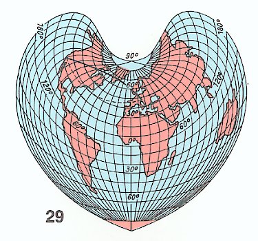
Thanks to the geographers at Bucknell University for this example of a cordiform map projection to mark the occasion.

One of the United States is actually called the Valentine State because it was admitted to the Union on this date in 1912. Take a guess, and then read all about it on Celebrating the States, one of Dr. Hayes-Boh's family blogs.


Valentine's Day is also a perfect day to talk about the Wedding of the Waters at Manaus, Brazil. This is described in some detail on a blog post for a 2009 EarthView visit in Brockton. That post includes links to further information about Rondonia, in the western part of the Amazon basin.

During our visit we also discussed the new partnership between Bridgewater State University and the University of the State of Santa Catarina in Brazil. Students from the two universities can now do extended exchanges, in order to improve language skills (in Portuguese or English) and to learn each other's countries in greater depth.

We also discussed the upcoming soccer championship in Brazil, the World Cup. We look forward to hearing about Mr. Claus' experiences as he actually attends the Cup in Rio! The games will be played throughout the country, though: learn more about the geography of the World Cup from our blog, which we will be updating during June.

We also spent some time discussing the latest major activity in the Ring of Fire -- a volcanic eruption in Java, Indonesia. Mount Kelud erupted loudly just yesterday. The eruption could be heard over 100 miles away, and ash was sent well into the stratosphere -- 12 miles into the sky. Most of the damage from this volcano is from the settling ash, which behaves something like a very heavy, dirty snow.


Friday, December 16, 2011

Mama Africa


During the EarthView program, we learned that Ms. Flanagan's class has been listening to African music in class. This reminded us of the Brazilian axe (ah-SHAY) singer Chico Cesar and his delightful song Mama Africa. The video above was filmed at his home in Bahia with his own mother and the rest of his family and neighbors. He sings with great joy and pride of Africa as his mother. Salvador, Bahia is where many Africans were first brought to Brazil as slaves. Slavery did not end in Brazil until 1888. Although it was a brutal practice, it has influenced the cultural geography of Brazil in many ways.

EarthView team member James Hayes-Bohanan started his study of Latin America as an environmental geography, but eventually became quite interested in the cultural geography of music in Latin America as well.

Friday, December 5, 2014

O'Maley Middle School, Gloucester -- December 5

Image: WikiMedia
42° 37' 44" N
70° 40' 23" W

Learn more about Lat/Long 

Today the EarthView team is visiting the northeasternmost portion of the Bay State: the Ralph B. O'Maley Middle School is just a couple of miles from the Atlantic Ocean in the famous fishing town of Gloucester.

Located on Cape Ann, this community is connected in many important ways to the Gulf of Maine, a "sea within a sea" that receives the waters of 60 watersheds. Geography students at O'Maley have recently been studying the nearby Gulf, which has some of the richest fisheries and most interesting tides in the world.


The sense of place is celebrated by new local restaurant, Latitude 43, which has a nautical theme and a geographic name. The team knows about the place because a son of team member Dr. Domingo was the construction manager.


When we returned from Gloucester, a student shared The Wreck of the Hesperus, Longfellow's famous poem based on two shipwrecks -- one near Gloucester and the other near Boston. It is required reading for many students in nautical New England towns.

During our visit, we spoke with some of the classes about the geography of currency. Every country in the world decides what currency it will use, and most of them print their own. When traveling, it is important to know the value of the currency. A sandwich that costs 5 dollars in the United States would cost 13 reais (HAY-ice) in Brazil and 132 cordobas in Nicaragua. These relationships -- known as exchange rates -- are always changing, and can be calculated on web sites such as XE.com.


We were speaking on the anniversary of the death of Nobel Laureate Nelson Mandela. His life was an inspiration, of course, to many people throughout the world, but was especially meaningful to the EarthView team, because our own Dr. Domingo began life as a black South African, and left for the United States before the dream of ending apartheid could be realized. Now when he visits his family, it is a very different country from the one in which he grew up.

Of course, we also talked about Nobel Laureate Malala Yousafzai, who will formally receive her award next year. In March, we learned that one of our favorite university geography texts was dedicated to her work on behalf of young women everywhere who want to learn.

Image: Rondonia Web
Several classes heard from Dr. Hayes-Bohanan about Rondônia, the state of Brazil where he studied to earn his doctorate in Geography & Latin American Area Studies. The photograph above is of a carving purchased during that field work, from an artist known as Anká. If you did not hear the story -- which involves a leaky boat, a 100-foot climb in the rain forest and many details he forgot to mention -- you can read it about it in Folha da Frontera (#3), a newsletter that was sent from the field. It is on Rondônia Web, along with a lot of other information about this part of the Amazon basin, and especially about its growing cities.

Lagniappe: Cape Ann or Annisquam Island?

During our visit, one of the geography teachers at O'Maley told the EarthView team that Cape Ann is actually an island. We had crossed a bridge to get to it, after all, and in fact there is no way to drive or walk there without crossing one of three bridges over the Annisquam River, and a quick look at Google Maps confirms this.


Because rivers to not separate islands from continents, we decided to investigate. Throughout most of its course, the Annisquam appears to be a natural river, mostly estuary. In the headwaters at the far southeastern end of the river, however, the banks are unnaturally straight, suggesting human engineering, and the name Blynman Canal confirms this. The history of this very short canal is an interesting one, having first opened in 1643, but not being permanently navigable until two centuries later.

By coincidence, we had mentioned the anniversary of the South Hadley Canal to some of the students. It is credited with being the first canal in the United States used for navigation, but as we can see, such superlative titles are always subject to debate.

Saturday, April 14, 2012

EarthView Institute -- Part 3

On Saturday, April 14, teachers from all over Massachusetts gathered for the third and final installment of EarthView Institute, in which they have earned their "EVI Driver's Licences" that will enable them to take EarthView back to their own communities.


Prior to going back to the gym so that they could show us their EarthView skills, we had another presentation by one of the EarthView team members. BSU geography student Ashley Costa talked about the cultural geography of Brazil from the point of view of her family heritage, her study-abroad experience in Porto Alegre, and the many Brazilian communities in eastern Massachusetts. Music was involved!

We watched the beginning of Brazil's Rising Star, a 60 Minutes interview with former Brazilian president "Lula" and we also discussed the recent visit of current president Dilma Rousseff, which is discussed on Dr. Hayes-Bohanan's Environmental Geography blog.

During lunch, we discussed the cultural and political geography of music from throughout Latin America.

From the teachers participating in the Institute, we learned a lot of new ways to use EarthView, which we will be sharing through this blog and our own presentations in coming months. For example, we paid more attention to the geography of Antarctica than we often do, and we are starting to find resources with which to develop that further.

Thursday, May 18, 2017

David Mindess School, Ashland -- May 19

42º 15' 50" N
71º 27' 40" W

Learn more about Lat/Long

The EarthView team is pleased to visit the Mindess School, located in the town of Ashland. It is in an area known as Metro West, meaning that it is in the western area of Boston's suburbs.


When preparing for our visit, the first thing we noticed is that the entire town of Ashland is preparing for a program called Courageous Conversations, for community youth and adults. 

It is good to be visiting a community that is committed to inclusion and open discussions. A key lesson from EarthView is that we are all connected on a single planet.

The second thing we noticed is that Ashland is the second town along the 26.2-mile long route of the world-famous Boston Marathon, which took place just a month before our visit. Ashland is part of the rural, mostly downhill part of the race. Ashland runners raised more than $30,000 for local charities during the 2017 marathon. 

Almost 30,000 people ran in the most recent race, representing every U.S. state and territory, and almost 100 countries around the world. This means that for one day in April, Ashland was probably the most international small town on the planet.
The Boston Marathon is named for the historic run of a soldier from the city of Marathon to the Greek capital Athens in 490 B.C. That route was run again in the 2004 Olympics and remains popular for runners wanting to try the original route. Notice the elevation profile at the bottom of this route map. Elevation and temperature are two very important factors for the runners.

Another interesting marathon took place in New York City in 1908 -- after the tradition had begun in Boston, but before the modern route in New York City was established. Inside Madison Square Garden, Johnny Hayes and Dorando Pietri were the only participants in an indoor marathon -- 262 laps of just one-tenth of a mile. As boring as that sounds, the arena was full of spectators!

Plus: It's About Time!


People in Ashland are very interested in clocks. The local high school sports teams are even known as Clockers! The town is so proud of inventor Henry E. Warren that its other elementary school is named for him. The connection is this: Mr. Warren invented the electric clock. 

Although the electric clock is among the 135 inventions for which he won patents, he never intended to invent it. Rather, he was trying to improve instrument that regulate the flow of water through machinery, at a time when many industries in Massachusetts still used water to power their tools. Master of Time is a short article about his life and the connections among water, power, and time that Henry Warren understood so well.

Clocks are of great importance to geographers, because they are essential for finding longitude. Geographers know how to estimate the latitude wherever they are, as long as they can see the noon sun and they know the current date. Because longitude is arbitrary -- based solely on the position of the Royal Naval Observatory in the United Kingdom -- it cannot be determined by observation alone. 

British inventor John Harrison realized the importance of this, and invented the clock, so that ships at sea could use to compare Greenwich time with local time. For this he won the Longitude Prize.
Harrison designed .a clock 300 years ago that he thought would be more accurate than any other, but he was not able to build it. Using modern materials, horologists (clock experts) built this one, and put it in a sealed container in the foundation of the Royal Naval Observatory in Greenwich, directly on the Prime Meridian. In 2015, they confirmed that it is the most accurate mechanical clock ever constructed!

Lagniappe: Brazzzzzil

We were pleased to meet quite a few students with ties to Brazil -- either born in the country or having parents who were. Most of these connections are in the state of Minas Gerais, which literally means "General Mines" and is the source of many minerals in Brazil.

One class mentioned that they had studied the problem of bees that are disappearing because of deforestation in the Amazon basin. EarthView team member Dr. Hayes-Bohanan mentioned that he had actually encountered Africanized bees when doing field work in Rondônia in 1996. From another geographer who was studying at the same time, he learned that wherever the forests had been cleared, Africanized bees competed for territory and replaced ordinary honey bees. For more of the story, scroll down to What's the Bzzzzzzzzz? on his journal Folha da Frontera.

Tuesday, April 2, 2013

Out of this World -- Sort Of

The geographers at Bridgewater State University are fortunate to have good relationships with geographers around the world. One of these is Dr. Francisco Henrique de Oliveira of the University of the State of Santa Catarina in Florianopolis, Brazil. As a specialist in surveying and mapping, he shares many interesting stories and images related to geotechnology.

He recently shared this graphic, which compares seven satellite orbits, including those of the International Space Station (ISS) and the the Global Positioning System (GPS). The highest orbit shown is the geostationary category, which includes a variety of satellites -- such as those used for television -- that need to stay in a constant position over the earth. (Learn more about GPS from our Where We Are post.)


We are working on exercises to compare these orbits at EarthView scale. For example each of the 24 satellites in the GPS system would orbit about 30 feet away from the surface of EarthView.

Please notice a few things about the diagram.

First, although it might seem to imply that all orbits run over the North and South Poles; this is not the case but simply makes the diagram readable.
Second, notice that the distances are expressed both as height above sea level and radius from the earth's center; the difference, of course, is the radius of the earth, about 4,000 miles.
Third, notice that the speed varies with height, with lower-orbiting satellites moving much faster than those at greater height.
Finally, notice that the time required to complete a full orbit increases with height; this is relationship between increased circumference and decreased speed as height increases.

Friday, July 4, 2014

Putting the CUP in World Cup

As the EarthView team has been discussing with students all year, the World Cup football (or "soccer" tournament) provides a lot of opportunities to learn about geography. Teams from all over the world have come to Brazil to compete, and they are doing so in about half of the states of that country.

Among the opportunities this has provided for learning about geography, the Rainforest Alliance has created one of the most interesting for its Frog Blog. For each pair of competing teams, a scorecard compares several measures of forest protection, including some statistics related to beverages that come from forests: tea, cocoa, and coffee.


In addition to the scorecard, an article about each pair discusses the kind of forests within the two countries, how well they are protected, and connections to protected forests elsewhere. Browse the entire World Cup Archives, and then explore the rest of the Rainforest Alliance blog to learn more about forest protection throughout the world.

Friday, March 15, 2013

Sharon Middle School -- March 15

42° 06' 24" N
71° 09' 58" W 
Learn more about Lat/Long (including how to look them up by address)
Also, compare today's coordinates to those of other recent EarthView outings, near and far!
 

NOTE: It was a very snowy year. This visit was postponed until May 24.

This is EarthView's second visit to Sharon Middle School. The blog post for our April 2012 visit describes the town of Sharon in terms of both site and situation -- geographic characteristics of the place itself and of the place in relation to other places. Just as that visit took place on the anniversary of historic events with geographic significance, so also does this Ides of March visit.

March 15 in Geographic History
1991 Amazon territories Roraima and Amapa become the last states of Brazil
1988 NASA reports damage to the ozone layer, caused by chloroflourocarbons
1971 First Internet chat rooms
1966 Watts riots in Los Angeles
1964 President Lyndon Johnson calls for War on Poverty
1961 South Africa withdrew from the British Commonwealth
1960 Key Largo Coral Reef Preserve established as the first underwater park, now part of the Florida Keys National Marine Sanctuary
1957 The United Kingdom becomes the third country to explode a nuclear bomb
1952 The greatest 24-hour rainfall began on the French Island of La Reunion, with 187 cm recorded. Where is this located, and how much rain would this be in inches? How tall are you in centimeters?
1869 Cincinnati Red Stockings become the first professional baseball team


Friday, June 6, 2014

Tantasqua Regional Jr. High School, Fiskdale -- June 6th

42° 09' 24" N
72° 07' 44" W


Tantasqua Junior High School


Today, Earth View returns to Tantasqua Regional Junior High School in  Fiskdale, MA. Last month the students of this school finished taking their yearly MCAS tests and are ready to explore the world with some EarthView fun!

To learn more about this school and its upcoming events, feel free to visit the Tantasqua website.

Each year the Tantasqua visit is a special one for EarthView, because it is the school where the Globe Lady became a geography teacher! She started there as a French teacher (her native language is French) but in the 1980s attended a special summer institute at National Geographic, and began her transformation into the fabulous and fabled geography educator we now know and love!

Because the Tantasqua students have been studying Latin America recently, the Globe Lady is rocking her Chichen Itza, Maravilla del Mundo (Marvel of the World) shirt and hat today, and discussing the exploits of EarthView team members in Mexico, Peru, Nicaragua and Brazil.

D-Day, World War 2, the invasion of Normandy, France.
Our June 6 visit takes place on the 70th anniversary of D-Day, also known as the Normandy Invasion. Over 160,000 troops from the United States, United Kingdom, Canada, and France itself assembled off
 the coast of Normandy overnight and landed on several beaches, including the famous one known as Omaha.  The landing made way for

Map courtesy of Blue Ox.

Other June 6 anniversaries:

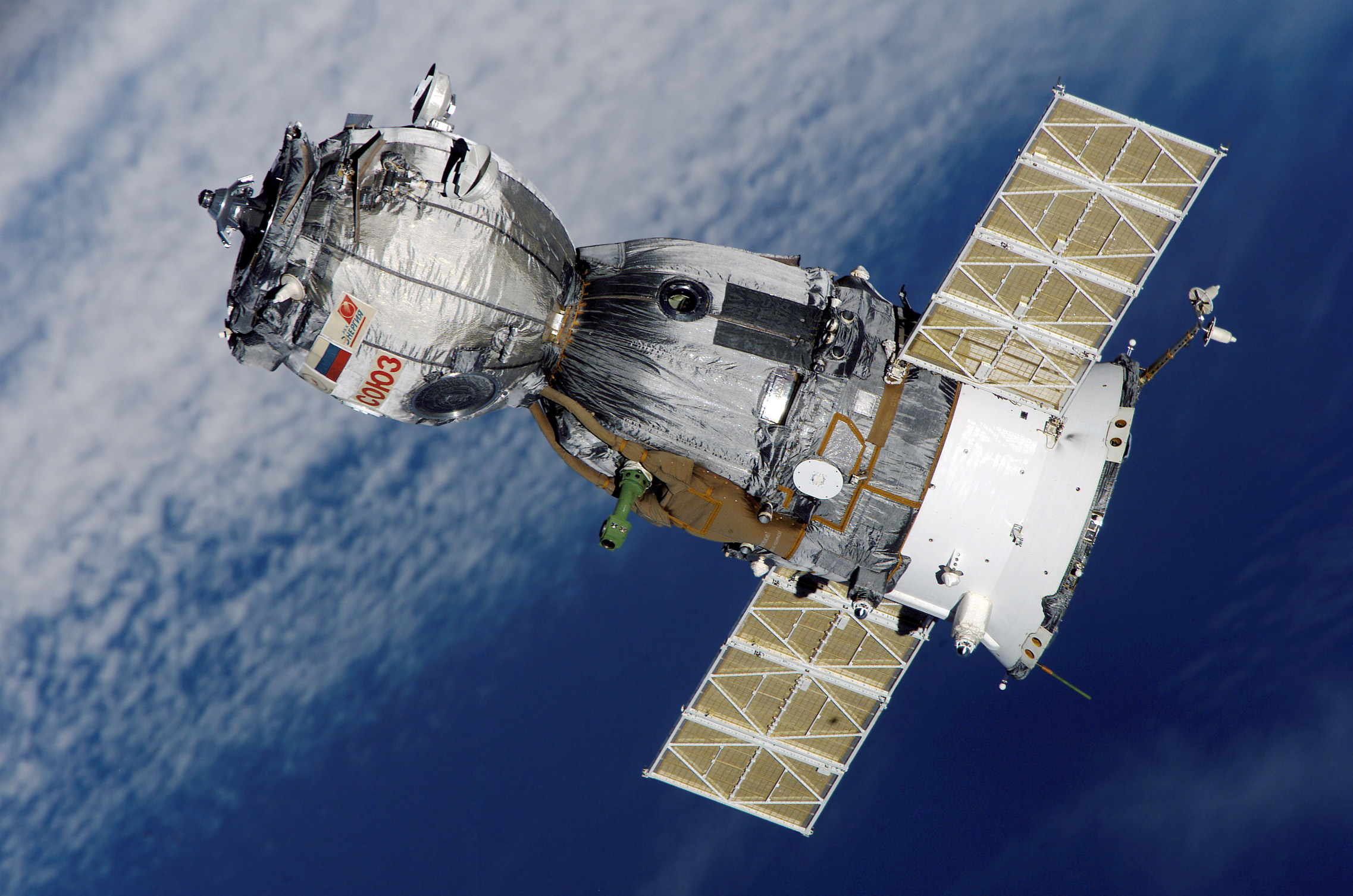
1971- The Soyuz 11 was launched into space and docked at Salyut orbital space station the next day.
1978- "20/20" TV premiere date.
This is also Memorial Day in Korea, where the nation pays tribute to the fallen soldiers with a ceremony held at the National Cemetery in Seoul.


The Soyuz 11 From the USSR  was launched into space and docked at Salyut orbital space station the next day.
National Cemetery in Seoul.

Wednesday, August 27, 2014

Florianópolis -- Sept 17-19

27°35′09"S
48°30′18"W
Learn more about Lat/Long


One of many popular views of Florianópolis, also known as Floripa.
Careful readers will notice that this is a first for EarthView. Never before has it appeared in the Southern Hemisphere, nor has it been so far east. It has certainly never been farther from its home base in Bridgewater! EarthView will be appearing in schools in Florianópolis and also at an international conference on planning and development, with over 500 geographers and other professionals.

Former BSU students will be helping with the event, though. Because of exchange programs between Bridgewater State University and the University of the State of Santa Catarina (UDESC), several geographers in Florianópolis have spent a semester in Massachusetts. Most of those students found the snow very interesting, as they had never seen it before in their lives!

Florianópolis is the capital of the state of Santa Catarina, in the far south of Brazil. Most of the city is on a beautiful island, which is one reason BSU students have enjoyed our UDESC exchanges. The main benefit, though, has been the chance to know the hard-working, fun, and friendly geographers of UDESC. Because of a new agreement between the two universities, students from any discipline can now study with BSU in Floripa, or in Bridgewater with UDESC!

Friday, May 24, 2013

Sharon Middle School -- May 24

42° 06' 24" N
71° 09' 58" W 
Learn more about Lat/Long (including how to look them up by address)
Also, compare today's coordinates to those of other recent EarthView outings, near and far!
 

This is EarthView's second visit to Sharon Middle School. (We were originally scheduled for the Ides of March, but were snowed out.) The blog post for our April 2012 visit describes the town of Sharon in terms of both site and situation -- geographic characteristics of the place itself and of the place in relation to other places. 


Today the EarthView team celebrates Sathwik Karnik's victory in the Natiional Geography Bee. The Karnik family of Plainville, Massachusetts is well known to us, as both Sathwik and his brother have been state bee champions and national finalists.

His winning answer was Chimbarazo, the world's tallest mountain, when measured from the center of the earth.

View Larger Map

Today is also a good day to talk about MOVEMENT, which is one of the Five Themes of Geography. This theme refers to the movements of people, products or ideas that connect PLACES.

May 24 is the anniversary of at least three important events that made future connections possible, and last night a bridge collapse led to a temporary but important loss of connection.

In 1844, the "Victorian Internet" began, as Samuel Morse sent the first telegraph message from Washington to Baltimore. The map below shows another kind of connection between the two, along the Interstate Highway System.


View Larger Map


During the EarthView presentation, Dr. Hayes-Bohanan mentioned the unusual relationship between the telegraph and the Brazilian city of Porto Velho. The connection is explained in the 1999 article Post-Frontier Towns of Rondonia, Brazil, with much more information about the region at Rondonia Web.


On this date in 1883, the Brooklyn Bridge connected the two largest boroughs of New York City -- Manhattan and Brooklyn. John Roebling had constructed a similar bridge connecting Covington, Kentucky to Cincinnati, Ohio in 1866, but it is not quite as famous.


View Larger Map


In 1976, supersonic commercial air service connected both London and Paris to Washington, DC, as a Concorde SST was sent from each city to Dulles Airport in nearby Virginia. (The mother and aunt of EarthView team member Dr. Hayes-Bohanan were both there, but he had to go to school that day!) The map below from Geography of Transportation at Hofstra University shows all of the Concorde routes, since retired.

Finally, as mentioned above an important loss of connection occurred last night, when the Skagit River bridge over Interstate 5 collapsed. At least one small truck fell into the river, but nobody was severely injured. The bridge has been described as a major connection between the city of Seattle and the country of Canada. Google Maps already shows that segment as missing, so that navigation systems relying on Google Maps will not send drivers that way. Explore the map to see how difficult the rerouting of people and cargo will be while the bridge is being repaired.

View Larger Map


Friday, May 12, 2017

Rumney Marsh Academy, Revere -- May 12

42º 24' 47" N
71º 00' 12" W

Learn more about Lat/Long

Rumney Marsh Academy is a school that the EarthView team enjoys visiting each year, because students there study geography throughout the year. It is especially fun to arrive late in the school year, when the geography learning among sixth graders has been going on for months!

Visit our 2016 Rumney-Marsh post and earlier posts for information about our previous visits and about the marsh (wetland) for which the school is named. You can also read about its nearest neighbor -- a famous candy company. How many middle school students are lucky enough to be across the street from a candy factory? It is like Willy Wonka, but in real life.

Water Volumes

Our visits inside of EarthView always begin with a discussion of the Earth's water, and the fact that the vast majority of it is in forms (saltwater or ice) that humans cannot use for drinking, bathing, irrigation, or industry. We have this discussion in terms of percentages, but today a student asked what the total volume of the water would be. "Millions of cubic miles," we said, promising to look up the actual figures.

According to the United States Geological Survey (USGS), the volume of water on the earth is 332,500,000 cubic miles (mi3), or 1,386,000,000 cubic kilometers (km3). The image below shows what the earth would look like if all of the water were removed from oceans, ground water, streams, and lakes.
The largest blue sphere represents all of the water on earth. The smaller sphere -- situated over Kentucky in the United States -- represents only the liquid, fresh water. The tiniest sphere of all -- a dot that appears to rest on Georgia -- represents all of the surface water. Of that, about 20 percent is in the Amazon River Basin, and another 20 percent is in Lake Baikal in Russia. Learn more at the USGS How Much Water? page.

NEW (May 30, 2017): Speaking about this with the geography teachers at our EarthView Institute, we realized that we can update our presentation about water to include not only percentages, but also the absolute volumes of the various ways water is stored. Using the USGS site mentioned above and refreshing our memory of sphere-related formulae with the sphere calculator page, we created a new spreadsheet detailing earth's water at an EarthView scale. For example, we learned that all of the fresh liquid water at or above the earth's surface could fit inside a ping-pong ball at the scale of EarthView!

South-Up Map

We also spent a lot of time at our Hobo-Dyer-Mead map learning about the importance of relative size. An interesting way to learn more is to use the TrueSize web site, which allows viewers to select a country or U.S. state, and visually drag it to other parts of the world for comparison.
The "Lower 48" portion of the United States, for example, is about the size of Brazil. Often, the familiar Mercator projection gives us the wrong idea of the relative size of places.


Thursday, July 20, 2017

Sanctuary, Marshfield -- July 20

N 42° 05' 50" W 70° 43' 45"
(including how to look them up by address)

The EarthView is very pleased to be part of the Sanctuary Day Camp at the Sanctuary congregation in Marshfield. Campers have been learning and celebrating many different things about the earth, its environments and peoples. Throughout the day, learners of all ages were able to use EarthView and our Hobo-Dyer-Mead south-up map to locate places they were interested in.
EarthView is a physical map; it works well in combination with the
 Hobo-Dyer-Mead map from ODT Publishing.
One of the places we mentioned to campers is the city of Macapá, the capital of the State of Amapá, Brazil. It is a city that is located where the Equator meets the Atlantic Ocean. Famously, its main soccer (football) stadium (Milton Stadium Souza Corrêa) is positioned so that opposing teams are in opposite hemispheres, with the centerfield line at 0 degrees latitude!

Thursday, May 8, 2014

Barnstable Intermediate -- May 9

42°06' 24" N
71°09' 58" W
Learn more about Lat/Long (including how to look them up by address)
Also, compare today's coordinates to those of other recent EarthView outings, near and far!


Barnstable Intermediate is in the village of Hyannis, which is part of Barnstable 

Hyannis is known as the location for ferries connecting Nantucket and Martha's Vineyard to the mainland. It is even better known as the home of the Kennedy family. A museum dedicated to President Kennedy and the entire family is located just down Main Street from the Intermediate School.


Barnstable Quick Facts
Population:                                                45,193 
Land area in square miles:                     59.81
Persons per square mile:                        775.7
Established 1639
Barnstable became a city in the year  1989.


Voter Registration and Party Enrollment 

as of October 15, 2008

 Democratic 8,242 -- 25% 
Republican 5,836-- 18% 
Unaffiliated 18,073-- 56% 
Minor Parties 235 -- 1%
Total   32,386


Because students at Barnstable Intermediate had been studying the Amazon basin and rain forest earlier in the year -- and since our visit is taking place on Dr. Hayes-Boh's wedding anniversary, we pointed out the location in the center of the basin where the Amazon River officially begins: the confluence of the Rio Negro and the Rio Solimões at Manaus, which is known as the Wedding of the Waters. Dr. Hayes-Boh saw the "wedding" on his way to Rondonia during his first trip to Brazil.
The Ring of Fire is a popular theme to explore in EarthView because it is a great way to see the active areas around the Pacific Ocean all at once. At the time of our visit, the latest major activity on the Ring of Fire was a 6.4-magnitude earthquake in Mexico.

Image: USGS Earthquake Center
Notice that the lat/long are in decimal degrees, as are many online maps
A good classroom exercise is to convert to degree-minute-second
The 6.4 magnitude earth quake happened on May 8th around 10:20 in Guerrero, Mexico. The news agencies in Mexico reported that there where no major injuries or damage.  Mexico City is vulnerable to distant earthquakes because much of it sits on top of the muddy sediments of old drained lake beds. The last major earth quake that hit was in 1985, it was a magnitude 8.1. That particular quake killed over 6,000 people and destroyed many buildings in mexico City. Yesterday's earthquake caused a brief period of evacuation from tall buildings, but turned out not to be significant.

Located at the top of 3 of the large tectonic plates, Mexico is also one of the world's biggest areas with active volcanoes. The motion of these crustal plates cause frequent earthquakes and occasional volcanic eruptions.  Mexico is being carried northeastward by the Cocos plate which lies under the Pacific Ocean. Because oceanic crust is dense, when the Pacific Ocean floor encounters the lighter continental crust of the Mexican landmass, the ocean floor moves beneath the North American plate creating the deep Middle American trench along Mexico's southern coast. Also, as a result of this, the westward moving Mexico landmass slows and crumples which creates the mountain ranges and earthquakes near the southern coast. 

Read more about subduction zone on our 2011 Japan earthquake post.
The last group of the day was a seventh-grade class studying ancient civilizations. Even though the curriculum for this subject is focused on the ancient civilizations around the Mediterranean Sea, students were aware of the ancient civilizations of the "New" World in the Americas, including the Incas, the Maya (who discovered chocolate), and the Aztecs. We discussed Dr. Hayes-Boh's upcoming trip to Machu Picchu later this month -- it is a significant Inca site that was not known to the Spanish until several centuries after they colonized Peru.


It is difficult to imagine that such a remarkable feature was not known beyond its immediate neighborhood until the late 1800s.

Image: Destination Machu Picchu

Monday, December 10, 2012

Population Primer

Our friends at geography.about.com recently posted reposted an article about the growth of the world's population over the past twenty centuries and to the end of the current one. (The article also has a lot of links to other useful articles about population.) I quickly copied the numbers into Excel to make the following simple graph.
Viewed from Year 1 (A.D. or C.E. -- Current Era) until 2083, population takes the form of the letter J, or perhaps a hockey stick. That is, it grew very gradually for 1800 years (and for about 8,000 years before that), and really grew significantly only in the past century or two. The population has more than doubled, in fact, since the members of the EarthView team were born. This is not true of the Wranglers who are still in college, though the planet now has almost 2 billion people on it than when they were born!

A J-curve represents exponential growth, which shows no sign of stopping. A more careful look at these numbers, however, reveals that the growth is actually not shaped like a J. By graphing the data only since 1804, a subtle but important shift in the pattern can be more easily seen.
These are the same numbers, except that the earlier, long period of very slow growth has been removed. Rather than a J, the growth resembles an S, which is why this pattern is called sigmoidal, after sigma, which is the Greek letter equivalent of S.

This kind of growth occurs with many living things, including humans. Rapid growth often occurs when resources are abundant, and then slows as resources become scarcer. What looks like unstoppable growth slows down when limitations are reached.

In the case of humans, agriculture allows for significant growth, but industrialization allows for growth that is much more rapid, at least initially. Many regions have experienced what geographers call a demographic transition, as the rapid growth eventually slows. As explained on the BBC "Bitesize" article on population change and structure, these changes do not result from rising birth rates, but rather from falling death rates.

Most of the world's industrial countries -- such as the United Kingdom, the United States, Italy, and Japan --
have been through some version of the demographic transition and now have relatively slow growth, or even negative growth. Many developing countries -- such as Mexico and Brazil -- are near the end of such a transition. Most importantly, even in countries where population growth rates remain high -- such as Kenya and Jordan -- the transition is beginning, and growth is beginning to slow. (See the Census Bureau International Database detailed estimates of population change in these and all other countries.)

CLICK to ENLARGE
Mexico's current population pyramid shows that the country's population has
 been growing in recent generations, but that growth in the future
will be slower. This kind of graph is more properly called an
age-structure diagram because not all countries resemble pyramids.
The Census IDB generates diagrams for individual countries by year.
National Geographic provides a
 lesson on making andinterpreting the diagrams.
The result is that although human population is expected to grow by an additional 3 billion people before this century is ended, it is not expected to grow much beyond that.

For geographers and other scientists who are concerned about the demands a growing population places on natural resources, it is encouraging to see that the growth of population is slowing down. Biologist E.O. Wilson has described this curve as a "bottleneck" because it shows a period of rapid growth that is lasting for only a couple of centuries. For a long time before and after this period, human population growth was and will be very slow. Most of the plants, animals, and resources that survive this rapid change are likely to survive long-term, but survival during this period requires a lot of care and protection.