42° 20' 51" N
71° 05' 03" W
Learn more about Lat/Long
The EarthView team is pleased to be part of the annual meeting of the National Council for the Social Studies. Thousands of social-studies educators from throughout the United States are at the Hynes Convention Center in Boston to share ideas about teaching and learning. We have enjoyed meeting teachers from throughout New England at the NERC regional meetings for several years, and are pleased to now bring EarthView to the national community of teachers.

EarthView team bios, guidelines, and more.
Friday, November 21, 2014
Thursday, November 13, 2014
Ahern School, Foxboro -- November 14
42° 4' 27" N
71° 14' 18" W
Learn more about Lat/Long
The EarthView team is pleased to return to the Ahern School, which has been part of the program almost every year since it began. By now, well over a thousand Ahern students have been among the 50,000 EarthView participants! You can read some of the things we shared on the blog for our 2010, 2011 and 2012 visits -- including some toponym notes.

Because geographers study many kinds of spatial patterns, we interact with a lot of other scientists and scholars. Biogeography, for example, is closely related to ecology. The National Center for Ecological Analysis and Synthesis (NCEAS) supports Kids Do Ecology which includes World Biomes. As geographers who know that any kind of region can be defined according to different criteria, we appreciate that this web site explains that even the number of biomes can vary, depending on those criteria.
We include biomes here because we know that they are an important part of how Ahern students are learning world geography this year. Biomes are types of biotic (biological) communities, each of which can be found anywhere in the world that certain abiotic conditions are found. That is, if climate and soils in two places are similar, then similar plants and animals are likely to be found. EarthView is a wonderful place to learn about the spatial arrangement of major biomes on the planet, in their correct proportions and relative locations.
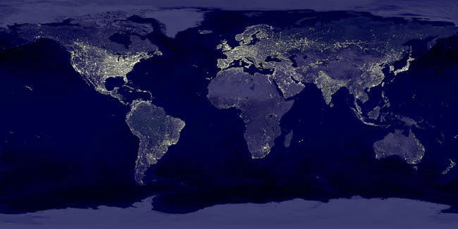 As Ahern students have been learning, biomes are among the physical factors that influence the distribution of human populations. The famous "Earth at Night" image is not exactly a population-density map, but brightly-lit areas tend to be those of significant human settlement. What biomes are found in the places with very few humans? What are some other factors that encourage or discourage human settlement?
The image above appears on Dr. Hayes-Bohanan's Environmental Geography blog but is also available as a poster, and appeared as NASA's Astronomy Picture of the Day on November 27, 2000. Notice that it is a "picture" and not a single satellite image. No single view can show the whole planet at once -- except of course EarthView!
Yesterday's APOD was equally spectacular -- the first image ever transmitted from a comet! Visit the November 13, 2014 APOD page to learn about the details of this image, taken from just 2 miles above the surface of the comet known as C67/P Churyumov-Gerasimenko, which is 300,000,000 miles from earth and moving at speeds of up to 80,000 miles per hour. This is so far away -- 30 light-minutes -- that signals between the European Space Agency (which launched the mission) and the probe are delayed by 30 minutes each way! Read many details of the mission on the ESA's Rosetta FAQ.

71° 14' 18" W
Learn more about Lat/Long
The EarthView team is pleased to return to the Ahern School, which has been part of the program almost every year since it began. By now, well over a thousand Ahern students have been among the 50,000 EarthView participants! You can read some of the things we shared on the blog for our 2010, 2011 and 2012 visits -- including some toponym notes.
Because geographers study many kinds of spatial patterns, we interact with a lot of other scientists and scholars. Biogeography, for example, is closely related to ecology. The National Center for Ecological Analysis and Synthesis (NCEAS) supports Kids Do Ecology which includes World Biomes. As geographers who know that any kind of region can be defined according to different criteria, we appreciate that this web site explains that even the number of biomes can vary, depending on those criteria.
We include biomes here because we know that they are an important part of how Ahern students are learning world geography this year. Biomes are types of biotic (biological) communities, each of which can be found anywhere in the world that certain abiotic conditions are found. That is, if climate and soils in two places are similar, then similar plants and animals are likely to be found. EarthView is a wonderful place to learn about the spatial arrangement of major biomes on the planet, in their correct proportions and relative locations.

The image above appears on Dr. Hayes-Bohanan's Environmental Geography blog but is also available as a poster, and appeared as NASA's Astronomy Picture of the Day on November 27, 2000. Notice that it is a "picture" and not a single satellite image. No single view can show the whole planet at once -- except of course EarthView!
Yesterday's APOD was equally spectacular -- the first image ever transmitted from a comet! Visit the November 13, 2014 APOD page to learn about the details of this image, taken from just 2 miles above the surface of the comet known as C67/P Churyumov-Gerasimenko, which is 300,000,000 miles from earth and moving at speeds of up to 80,000 miles per hour. This is so far away -- 30 light-minutes -- that signals between the European Space Agency (which launched the mission) and the probe are delayed by 30 minutes each way! Read many details of the mission on the ESA's Rosetta FAQ.

Monday, November 10, 2014
Maps & Meaning
42° 23' 11"N
71° 16' 22"W
For coordinates by address in the U.S., check Stephen Morse, or use an atlas, globe, or Google Earth for other places throughout the world.
EarthView has returned to the Cambridge School of Weston, an independent, progressive high school with a rich history of innovative teaching. Co-coordinator James Hayes-Bohanan took it there for his daughter's "Maps & Meaning" class last year. Students from that class were so energized by this unique way of experiencing a map that this year's class was eager to have EarthView return.
The visit was a reminder that students of any age can get excited about seeing the world in a new way. It is also a reminder that a map or globe can be used for lots of different kinds of learning. Because students in these classes had been analyzing the ways maps can represent the same reality differently, their questions about EarthView were quite interesting. As the video below makes clear -- the students gave EarthView a very warm welcome.
One of the questions of perception asked by a CSW student is actually one that the EarthView team hears a lot -- "Is it in the correct proportions?" Most people do not spend much time looking at world maps, and even less time looking at globes. And the most commonly viewed maps use a Mercator or similar projection that greatly exaggerates the size of land masses at high latitudes -- so that Greenland rivals South America and Antarctica looks like a very wide rectangle. In reality -- and in EarthView -- Greenland is rather small, Antarctica is rather round, and Africa is much bigger than most people expect it to be. Also, since many projections divide the Pacific Ocean, almost everyone who enters EarthView is surprised at its size.
We discussed the question of whether new islands are still being discovered, and in fact some are, and it is sometimes difficult to know whether they are new discoveries, newly precise ways of viewing complex groups of islands, or perhaps new lands formed by volcanoes. A couple of years ago, though, we did learn about the opposite -- the undiscovery of Sandy Island, an island that never existed, but which has appeared on maps for 200 years.
 |
| Image; Auckland Museum |
Sunday, November 2, 2014
South Middle, Braintree -- November 7
38°41'50" S
176°06'16" E
The EarthView team usually uses the top of each blog post to report the geographic coordinates of the schools we visit. This week, we begin with a location that is very far from Braintree -- almost as far away as possible.
Consider how the coordinates above relate to these:
38°41'50" N
3°53'44" W
How could one use the principal lines of the globe -- equator, prime meridian, and International Date Line -- to calculate one of these pairs, based on the other?
Where are these places, relative to each other?
Search each pair at Google Maps to find out a bit more about each place. What language is spoken in each? Which one has a connection to South Middle's geographer extraordinaire, Mr. Henry?
These questions all relate to the geographic concept of antipodes, which are explained in some detail in Who Can Dig to China? on Environmental Geography, the college-level blog of EarthView team member Dr. Hayes-Bohanan.
For information about the coordinates of South Middle School -- and how they compare to those East Middle and other Massachusetts locations -- see the classroom exercise described in our East Middle School post from our Halloween visit to that neighboring school.
176°06'16" E
The EarthView team usually uses the top of each blog post to report the geographic coordinates of the schools we visit. This week, we begin with a location that is very far from Braintree -- almost as far away as possible.
Consider how the coordinates above relate to these:
38°41'50" N
3°53'44" W
How could one use the principal lines of the globe -- equator, prime meridian, and International Date Line -- to calculate one of these pairs, based on the other?
Where are these places, relative to each other?
Search each pair at Google Maps to find out a bit more about each place. What language is spoken in each? Which one has a connection to South Middle's geographer extraordinaire, Mr. Henry?
These questions all relate to the geographic concept of antipodes, which are explained in some detail in Who Can Dig to China? on Environmental Geography, the college-level blog of EarthView team member Dr. Hayes-Bohanan.
 |
| We don't know where this humorous photo was taken. It would be accurate only in parts of Chile and Argentina. The antipode locations for most of China are in the southern Pacific and Atlantic Oceans. |
Subscribe to:
Comments (Atom)