42º 24' 47" N
71º 00' 12" W
Learn more about Lat/Long
Rumney Marsh Academy is a school that the EarthView team enjoys visiting each year, because students there study geography throughout the year. It is especially fun to arrive late in the school year, when the geography learning among sixth graders has been going on for months!
Visit our 2016 Rumney-Marsh post and earlier posts for information about our previous visits and about the marsh (wetland) for which the school is named. You can also read about its nearest neighbor -- a famous candy company. How many middle school students are lucky enough to be across the street from a candy factory? It is like Willy Wonka, but in real life.
Water Volumes
Our visits inside of EarthView always begin with a discussion of the Earth's water, and the fact that the vast majority of it is in forms (saltwater or ice) that humans cannot use for drinking, bathing, irrigation, or industry. We have this discussion in terms of percentages, but today a student asked what the total volume of the water would be. "Millions of cubic miles," we said, promising to look up the actual figures.
According to the United States Geological Survey (USGS), the volume of water on the earth is 332,500,000 cubic miles (mi3), or 1,386,000,000 cubic kilometers (km3). The image below shows what the earth would look like if all of the water were removed from oceans, ground water, streams, and lakes.
The largest blue sphere represents all of the water on earth. The smaller sphere -- situated over Kentucky in the United States -- represents only the liquid, fresh water. The tiniest sphere of all -- a dot that appears to rest on Georgia -- represents all of the surface water. Of that, about 20 percent is in the Amazon River Basin, and another 20 percent is in Lake Baikal in Russia. Learn more at the USGS How Much Water? page.
NEW (May 30, 2017): Speaking about this with the geography teachers at our EarthView Institute, we realized that we can update our presentation about water to include not only percentages, but also the absolute volumes of the various ways water is stored. Using the USGS site mentioned above and refreshing our memory of sphere-related formulae with the sphere calculator page, we created a new spreadsheet detailing earth's water at an EarthView scale. For example, we learned that all of the fresh liquid water at or above the earth's surface could fit inside a ping-pong ball at the scale of EarthView!
South-Up Map
We also spent a lot of time at our Hobo-Dyer-Mead map learning about the importance of relative size. An interesting way to learn more is to use the TrueSize web site, which allows viewers to select a country or U.S. state, and visually drag it to other parts of the world for comparison.
The "Lower 48" portion of the United States, for example, is about the size of Brazil. Often, the familiar Mercator projection gives us the wrong idea of the relative size of places.
The Geography Department at Bridgewater State University is proud to offer Project EarthView. This blog gives students who use EarthView a place to post follow-up questions and to find other cool geo-education resources. The blog has plenty of geography-education resources for grown-ups, too!
Friday, May 12, 2017
Friday, May 5, 2017
Clifford Marshall School, Quincy -- Cinco de Mayo
42° 15' 10" N
71° 0' 03" W
Learn more about Lat/Long (including how to look them up by address)
Also, compare today's coordinates to those of other recent Earth View outings, near and far!
This was our second visit to the Marshall School. The EarthView team knew that the students and families of Clifford Marshall School have come to Quincy from many places, and that the school community celebrates this. So we asked each of the third and fourth graders who came into EarthView to tell us where their families come from. We pointed them out during our visit and then put them on.a Google Map. With just one point in the center of each country of origin, we were able to make this quick map of the Marshall School community.
71° 0' 03" W
Learn more about Lat/Long (including how to look them up by address)
Also, compare today's coordinates to those of other recent Earth View outings, near and far!
This was our second visit to the Marshall School. The EarthView team knew that the students and families of Clifford Marshall School have come to Quincy from many places, and that the school community celebrates this. So we asked each of the third and fourth graders who came into EarthView to tell us where their families come from. We pointed them out during our visit and then put them on.a Google Map. With just one point in the center of each country of origin, we were able to make this quick map of the Marshall School community.
Friday, April 28, 2017
Alden Elementary, Duxbury -- April 28
42° 02' 48"N
70° 40' 49"W
(Center of the stage at the Duxbury Performing Arts Center)
Learn more about Lat/Long (including how to look them up by address)
Also, compare today's coordinates to those of your own home, family members, and other EarthView outings, near and far!
![]() |
| Alden School students walked through their school to the Duxbury Performance Arts Center, where EarthView was on stage for the day! Many thanks to the Alden PTO and to PAC director Tony Kelso. |
![]() |
| Duxbury's Landscapes -- from the Duxbury town web site |
EarthView has been in many towns near Duxbury in the past, but the Alden Elementary visit is our visit to Duxbury itself. The map below shows a purple pin for each school visit in the area. Click on EarthView Experience to see all of the places EarthView has traveled.
Members of the EarthView team have good friends in Duxbury, from whom we know that the Duxbury Beach is something of which people in the town are quite proud. It is home to migratory birds that require special care, and an entire organization exists to protect and promote the beaches of Duxbury.
Our visit took place on Maryland Day -- the anniversary of Maryland's admission to the Union (becoming one of the United States) on April 28, 1788.
Dr. Hayes-Bohanan and his wife Pamela (a BSU librarian) spent the year 2010 recognizing each of the United States on the anniversary of its admission. We read books, watched movies, and prepared food for each celebration. Maryland Day was a special celebration, because it is where they were married on May 9, 1987.
People from Maryland tend to be very proud of its flag, which is based on the heraldry of two families -- Baltimore and Calvert -- that helped to found the British colony that eventually became the state. Many Marylanders are also passionate about the Maryland blue crab, which grows in the Chesapeake Bay. The flag and the food are combined in a magnetic decal on Dr. Hayes-Bohanan's car that celebrates Maryland.
This is something people all over the world do -- sharing symbols that represent the sense of place of their home town or region. What are some examples of sense of place in your own town or in places that are important to your family? Examples could be foods, sports teams, landmarks, or many other features.
Our visit took place on Maryland Day -- the anniversary of Maryland's admission to the Union (becoming one of the United States) on April 28, 1788.
| Dr. Hayes-Boh celebrating Maryland's day to shine! |
People from Maryland tend to be very proud of its flag, which is based on the heraldry of two families -- Baltimore and Calvert -- that helped to found the British colony that eventually became the state. Many Marylanders are also passionate about the Maryland blue crab, which grows in the Chesapeake Bay. The flag and the food are combined in a magnetic decal on Dr. Hayes-Bohanan's car that celebrates Maryland.
This is something people all over the world do -- sharing symbols that represent the sense of place of their home town or region. What are some examples of sense of place in your own town or in places that are important to your family? Examples could be foods, sports teams, landmarks, or many other features.
Friday, April 7, 2017
Frolio Middle School, Abington -- April 7
42° 07' 06"N
70° 56' 47"W
Learn more about Lat/Long (including how to look them up by address)
Also, compare today's coordinates to those of other recent EarthView outings, near and far! Next year, Frolio student's will be asked to compare the coordinates of this gym and the gym in the new Abington Middle School.
The EarthView team is very pleased to return to Frolio, which we have visited every year since 2010. We always find students who have been actively engaged in learning geography, which we can tell because of the good questions they ask during our visits. We enjoy giving students a different way to look at the places and concepts they have been studying in their excellent geography classes throughout the year.
This will be the last time EarthView will be in Frolio's charming all-wood gymnasium, as a new school is under construction. Although we are happy that Frolio's teachers and students will have upgraded facilities, we will miss this gym, whose architecture is typical of public projects built by the Work Progress Administration in the 1930s.
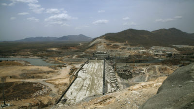
During today's visit, some classes learned about another kind of public-works project: dams.
| Grand Ethiopian Renaissance Dam under construction in 2015 |
With a capacity of 6,000 megawatts, it could provide electricity to about 9,000,000 households in the United States. Ethiopia has 94,000,000 people in about 20,000,000 households. With its lower level of electricity consumption, this dam will provide enough electricity to serve all of that county's household needs.
Although this is very good news for Ethiopian households, dams usually have both positive and negative effects. In the case of this dam, it is one of several problems for the Nile Basin, and especially for people and crops in Egypt. This is combined with the rise of sea level at the mouth of the Nile and other problems that some scientists call the Vanishing of the Nile.
annual meeting of the American Association of Geographers. EarthView has been a popular attraction at the conference, which has brought thousands of professional geographers to the Hynes Convention Center in Boston, along with publishers and technology companies that employ and serve geographers.
On Thursday and Saturday, EarthView has a spot at the entrance to the the HUUUUGE exhibit hall, next to interactive displays from Google and esri, each of which is a major provider of software for Geographic Information Systems and digital mapping.
Lagniappe: Farewell to Frolio
As mentioned above, the students and teachers of Frolio will soon be in more modern, spacious facilities, and we are glad for them. Like many of them, though, the EarthView team will miss this charming building, which began as Abington High School 80 years ago.
It was built during the Great Depression, one of thousands of projects around the United States that were funded by the Federal government under the leadership of President Franklin Roosevelt. The idea was to invest money -- even to borrow money -- in projects that would be good investments and would provide jobs for those who wanted to work but could not find employment.
The building later served as a middle school, named for a beloved teacher and principal. The EarthView team took a few photos today to remember this building, and we look forward to many more years with the Abington geographers in their new space.
![]() |
| Architectural details |
![]() |
| Charles Frolio's portrait, in the main entrance |
![]() |
| Memorial for Charles Frolio |
![]() |
| Details of the Federal Project that built the school |
![]() |
| EarthView at Frolio for the last time. |
Friday, March 24, 2017
Garfield Middle, Revere -- March 24
42° 24' 12" N
70° 59' 34" W
Learn more about Lat/Long (including how to look them up by address)
Also, compare today's coordinates to those of other recent EarthView outings, near and far!
The EarthView team is excited to be returning to Garfield Middle School, which we visited for the first time in May 2016. Our blog post from that visit includes photos of the magnificent flags that adorn Garfield's hallways.
This year, our visit comes during the week of World Water Day. During our EarthView program, we always discuss the importance of water, and how it is that we must conserve water, even though the planet has millions of cubic miles of it!
It is very fitting that this is the week that a court in New Zealand ruled that the Whanganui River is legally a person, with all of the rights and responsibilities that human persons have. The river flows 180 miles from Mt Tongariro to the Tasman Sea, and is of special importance to the Maori people, who sought this legal designation and will serve as the river's guardians.
70° 59' 34" W
Learn more about Lat/Long (including how to look them up by address)
Also, compare today's coordinates to those of other recent EarthView outings, near and far!
The EarthView team is excited to be returning to Garfield Middle School, which we visited for the first time in May 2016. Our blog post from that visit includes photos of the magnificent flags that adorn Garfield's hallways.
![]() |
| Garfield is a school that loves geography! |
![]() |
| Learn more about World Water Day from the United Nations |
Friday, March 17, 2017
Spofford Pond School, Boxford -- March 17
42°41'46"N
Lagniappe:
Happy St. Patrick's Day! In honor of the occasion, some Spofford Pond students were treated to a dad-level riddle by Dr. Hayes-Bohanan.
Q: Why is Ireland so wealthy?
A: It's capital is always Dublin. (Say it out loud.)
LAT/LONG Answers ... keep scrolling down
.
.
.
.
.
.
.
.
.
.
Latitude: Vatican City, Rome, and Tbilisi
Longitude: Santo Domingo, Santiago
71°01'02"W
(Visit more about Lat/Long for ideas that combine math and geography learning. This is our second visit to Spofford Pond, and it remains the farthest north we have taken EarthView.)
The EarthView team is always pleased to return to Spofford Pond School. Even though it is farther from our campus than most of the schools we visit, we always find it worth the journey, because the social studies classes at Spofford Pond include so much geography that we know we will find students who are eager for the EarthView experience.
Many of our previous Spofford Pond blog posts include information about the local geography of Boxford. Today's blog, though, will emphasize a few matters from farther afield. First is an event that occurred yesterday and that we mentioned during our Spofford Pond visit.
Yesterday, at 37°45' N, 15°00' E tourists were very surprised by an eruption of Mt. Etna, the most active volcano in Europe. Even though it is frequently active, prior movements usually allow the volcanologists to close the volcano to visitors prior to an eruption. Yesterday's eruption, however, was quite sudden, and injured some tourists and journalists who were on the volcano at the time.
Learn more about the world's volcanoes from the SI Global Volcanism Program.
![]() |
| The first satellite image was captured by Sentinel 2, part of the European Space Agency Copernicus program. |
![]() |
| Information on every volcano |
We also presented some challenges about latitude and longitude. If one circled the world at the same latitude (within a degree) of Spofford Pond, what three world capitals could you encounter? What if you circled half world at the same longitude? (Answers at the bottom of this article.)
HINT: For the first answer, two of the cities are in the exact same location; the other is the capital of a country whose name is also a U.S. state.
For the second answer, the two cities are named for saints.
Lagniappe:
Happy St. Patrick's Day! In honor of the occasion, some Spofford Pond students were treated to a dad-level riddle by Dr. Hayes-Bohanan.
Q: Why is Ireland so wealthy?
A: It's capital is always Dublin. (Say it out loud.)
LAT/LONG Answers ... keep scrolling down
.
.
.
.
.
.
.
.
.
.
Latitude: Vatican City, Rome, and Tbilisi
Longitude: Santo Domingo, Santiago
Friday, February 17, 2017
Littleton Middle School - February 17
42° 32' 32" N
71° 29' 14" W
Learn more about Lat/Long (including how to look them up by address)
Also, compare today's coordinates to those of other recent EarthView outings!
View Larger Map
The EarthView team is delighted to be returning to Littleton Middle School, where excellence in geography education is a hallmark of sixth-grade social studies.
One of the concepts we explored inside EarthView is the idea of antipodes -- places that are on precisely opposite sides of the planet. Although a lot of people think that China is opposite the United States, it cannot be, since both are in the Northern Hemisphere.
The antipode of Littleton Middle School is in the Indian Ocean, at S 42°32'32" E 108°30'46". These coordinates are found by using the same latitude but with the opposite direction, and by subtracting the longitude from 180 degrees before switching hemispheres.
During our 2016 visit to Littleton, our colleague Dr. Hellstrom from Bridgewater State spoke about his experience studying weather and climate change in the Andes Mountains of Peru. This year, we discussed a new BSU course that we will offer in Peru in July 2017 that will include Dr. Hellstrom's weather stations and coffee and cacao (chocolate) cooperatives at lower elevation.
71° 29' 14" W
Learn more about Lat/Long (including how to look them up by address)
Also, compare today's coordinates to those of other recent EarthView outings!
View Larger Map
The EarthView team is delighted to be returning to Littleton Middle School, where excellence in geography education is a hallmark of sixth-grade social studies.
One of the concepts we explored inside EarthView is the idea of antipodes -- places that are on precisely opposite sides of the planet. Although a lot of people think that China is opposite the United States, it cannot be, since both are in the Northern Hemisphere. The antipode of Littleton Middle School is in the Indian Ocean, at S 42°32'32" E 108°30'46". These coordinates are found by using the same latitude but with the opposite direction, and by subtracting the longitude from 180 degrees before switching hemispheres.
During our 2016 visit to Littleton, our colleague Dr. Hellstrom from Bridgewater State spoke about his experience studying weather and climate change in the Andes Mountains of Peru. This year, we discussed a new BSU course that we will offer in Peru in July 2017 that will include Dr. Hellstrom's weather stations and coffee and cacao (chocolate) cooperatives at lower elevation.
Friday, December 9, 2016
Forest Capital
During our visit to the Wynn School in Tewkesbury, our Wrangler Mr. Kevin told us about a country that will open its new capital in the same year that the Wynn students will be graduating high school in 2022.
The West African country of Equatorial Guinea is currently one of very few countries whose capital is on an island that is separate most of its mainland territory on a continent (Denmark is another good example).
In the case of Equatorial Guinea, this arrangement has proven difficult to maintain, so the government has embarked on a project to move its capital to a mainland location that will be known as Oyala. It is fitting that the United States is helping to fund this move, since we moved our own national capital a couple of times before the construction of Washington, D.C.
Read more about the challenges facing Equatorial Guinea and the reasons for this relocation on the BBC web site. The Monga Bay web site describes concerns about the 8,000 hectares of rain forest that would be cleared for construction.
The West African country of Equatorial Guinea is currently one of very few countries whose capital is on an island that is separate most of its mainland territory on a continent (Denmark is another good example).
In the case of Equatorial Guinea, this arrangement has proven difficult to maintain, so the government has embarked on a project to move its capital to a mainland location that will be known as Oyala. It is fitting that the United States is helping to fund this move, since we moved our own national capital a couple of times before the construction of Washington, D.C.
Read more about the challenges facing Equatorial Guinea and the reasons for this relocation on the BBC web site. The Monga Bay web site describes concerns about the 8,000 hectares of rain forest that would be cleared for construction.
![]() |
| This planner's rendering of the future capital Oyala resembles the PacMan video game, but it is a serious plan for settling 200,000 residents in the new city. |
Thursday, December 8, 2016
Wynn School, Tewksbury - December 9th
42º 37' 48" N
71º 18' 08" W
Learn more about Lat/Long (including how to look them up by address)
Also, compare today's coordinates to those of other recent EarthView outings, near and far!
The EarthView team is happy to be making our second school visit of the week to Wynn Middle School in Tewksbury! Last year we had an interesting trip to the school as our GPS devices failed us, bringing us to the wrong location! John W. Wynn Middle School is located at 1 Griffin Way, not 1 Griffin Road. This led to much confusion and a hilarious ride to school, the story about that adventure can be found here.
Our visit to the school last year also made national news! The article found in US News & World Report can be found here.
This week, we came across a neat video explaining the different map projections and why they are distorted! Give it a watch and tell us what you think!
If you would like to visit the website mentioned at the end of the video where you can see the true size of a country compared to other countries, visit thetruesize.com
We hope that the students of Wynn Middle School enjoy their visit with EarthView! We will be back to the school in January!
71º 18' 08" W
Learn more about Lat/Long (including how to look them up by address)
Also, compare today's coordinates to those of other recent EarthView outings, near and far!
The EarthView team is happy to be making our second school visit of the week to Wynn Middle School in Tewksbury! Last year we had an interesting trip to the school as our GPS devices failed us, bringing us to the wrong location! John W. Wynn Middle School is located at 1 Griffin Way, not 1 Griffin Road. This led to much confusion and a hilarious ride to school, the story about that adventure can be found here.
Our visit to the school last year also made national news! The article found in US News & World Report can be found here.
This week, we came across a neat video explaining the different map projections and why they are distorted! Give it a watch and tell us what you think!
If you would like to visit the website mentioned at the end of the video where you can see the true size of a country compared to other countries, visit thetruesize.com
We hope that the students of Wynn Middle School enjoy their visit with EarthView! We will be back to the school in January!
Ahern Middle School, Foxboro - December 6th
42° 4' 27" N
71° 14' 18" W
Learn more about Lat/Long (including how to look them up by address)
Also, compare today's coordinates to those of other recent EarthView outings, near and far!
After a brief hiatus from Thanksgiving Break, EarthView visits are back in swing! Our first stop this week brought us to Ahern Middle School in Foxboro.
We always have a wonderful visit with the sixth graders at the school whenever we stop by, and we have stopped by almost every year since the EarthView project began in 2008.
If you would like to see all of the blog posts we have written about our visits to Ahern, click here and here!
71° 14' 18" W
Learn more about Lat/Long (including how to look them up by address)
Also, compare today's coordinates to those of other recent EarthView outings, near and far!
After a brief hiatus from Thanksgiving Break, EarthView visits are back in swing! Our first stop this week brought us to Ahern Middle School in Foxboro.
We always have a wonderful visit with the sixth graders at the school whenever we stop by, and we have stopped by almost every year since the EarthView project began in 2008.
If you would like to see all of the blog posts we have written about our visits to Ahern, click here and here!
Friday, November 18, 2016
Tantasaqua Jr. High, Fiskdale -- Nov 18
42° 09' 24" N
The EarthView team is pleased, as always, to be returning to Tantasqua. We always enjoy our visits, because this is the home school of our very own Globe Lady, who taught French and geography there for many years before "retiring" and joining our team. She still teaches there from time to time when she is not traveling throughout the state to meet us wherever we take EarthView. We also know from experience that the students at Tantasqua are well-prepared in geography and eager to learn even more!
During our visit we will be using EarthView to help Tantasqua students visualize some of the geography lessons they have been learning; we will also be discussing a lot of additional geographic connections.
For example, Dr. Hayes-Bohanan will be speaking about several current connections to the country of Morocco. On Thursday morning, he was rowing a boat in New Bedford harbor when he saw Fortuna Bay -- one of the largest ships ever to enter that port turn to leave for the Panama Canal. He had taken this photograph a few days before, as the ship lay berthed in New Bedford as dozens of trucks took clementines from its hold, to be taken to Canada!
Many thousands -- perhaps a few million -- of these fruits had been gathered from throughout Morocco and loaded onto the Fortuna Bay when it was in Agadir, Morroco. The fruit was not ultimately destined for New Bedford, though. It was ultimately destined for store shelves throughout eastern Canada!
This week, however, Morocco .is part of a story that is much bigger than any fruit, no matter how delightful! For the past week, officials from 197 countries have been meeting in Marrakech, Morocco to discuss an international agreement to reduce climate change.
72° 07' 44" W
The EarthView team is pleased, as always, to be returning to Tantasqua. We always enjoy our visits, because this is the home school of our very own Globe Lady, who taught French and geography there for many years before "retiring" and joining our team. She still teaches there from time to time when she is not traveling throughout the state to meet us wherever we take EarthView. We also know from experience that the students at Tantasqua are well-prepared in geography and eager to learn even more!
During our visit we will be using EarthView to help Tantasqua students visualize some of the geography lessons they have been learning; we will also be discussing a lot of additional geographic connections.
For example, Dr. Hayes-Bohanan will be speaking about several current connections to the country of Morocco. On Thursday morning, he was rowing a boat in New Bedford harbor when he saw Fortuna Bay -- one of the largest ships ever to enter that port turn to leave for the Panama Canal. He had taken this photograph a few days before, as the ship lay berthed in New Bedford as dozens of trucks took clementines from its hold, to be taken to Canada!
Many thousands -- perhaps a few million -- of these fruits had been gathered from throughout Morocco and loaded onto the Fortuna Bay when it was in Agadir, Morroco. The fruit was not ultimately destined for New Bedford, though. It was ultimately destined for store shelves throughout eastern Canada!
This week, however, Morocco .is part of a story that is much bigger than any fruit, no matter how delightful! For the past week, officials from 197 countries have been meeting in Marrakech, Morocco to discuss an international agreement to reduce climate change.
| Climate meeting in Marrakech, Morocco |
Monday, November 14, 2016
Lt. Peter M. Hansen Elementary School, Canton - November 15th
42° 11' 00" N
71° 07' 44" W
Learn more about Lat/Long (including how to look them up by address)
Also, compare today's coordinates to those of other recent EarthView outings, near and far!
The EarthView team is excited to be visiting Lt. Peter M. Hansen Elementary School in Canton on Tuesday this week! Our last visit to the school occurred on June 1st, the blog post for that visit can be found here. Our very first visit to the school offered up some interesting information on how the town of got its name, that blog post can be found here.
Today's visit brings us on the National Day of Action, which calls those who are concerned about access to clean water, the destruction of sacred sites, and Native American sovereignty to come together and speak out in support of the Standing Rock Sioux and their protests to stop the construction of the Dakota Access Pipeline.
One way that you can show your support and have your voice heard is by visiting, rezpectourwater.com and signing the petition.
We hope that you will join us in showing our support for the Standing Rock Sioux and we hope that the students of Lt. Peter M. Hansen Elementary School enjoy their visit with EarthView!
71° 07' 44" W
Learn more about Lat/Long (including how to look them up by address)
Also, compare today's coordinates to those of other recent EarthView outings, near and far!
The EarthView team is excited to be visiting Lt. Peter M. Hansen Elementary School in Canton on Tuesday this week! Our last visit to the school occurred on June 1st, the blog post for that visit can be found here. Our very first visit to the school offered up some interesting information on how the town of got its name, that blog post can be found here.
Today's visit brings us on the National Day of Action, which calls those who are concerned about access to clean water, the destruction of sacred sites, and Native American sovereignty to come together and speak out in support of the Standing Rock Sioux and their protests to stop the construction of the Dakota Access Pipeline.
One way that you can show your support and have your voice heard is by visiting, rezpectourwater.com and signing the petition.
![]() |
| No DAPL |
We hope that you will join us in showing our support for the Standing Rock Sioux and we hope that the students of Lt. Peter M. Hansen Elementary School enjoy their visit with EarthView!
Thursday, November 3, 2016
Leominster High School - November 4th
42° 32' 01" N
71° 46' 45" W
Learn more about Lat/Long (including how to look them up by address)
Also, compare today's coordinates to those of other recent EarthView outings!
The EarthView team is excited to be visiting Leominster High School for the first time today! We very rarely get to visit with high school students, our last high school visit was to Middleboro High in 2009 and we actually ended up getting two Geography majors and EarthView wranglers from that visit!
This week's visit brings us during a time of turmoil in North Dakota due to the proposed Dakota Access Pipeline (DAPL) that is set to run through disputed Sioux territory, some folks claim it to be private property but others see it as rightfully belonging to the Sioux. Whether the land be private or Native American Reservation, the pipeline is set to be placed upriver from the Standing Rock Sioux Reservation which would threaten the water supply. Ironically, the pipeline was originally set to run upriver from Bismark however it was re-positioned as there was concern about the drinking water there. The map below clearly explains the situation and more information can be found on Dr. Hayes-Bohanan's environmental geography blog here.
We hope that the students of Leominster High School enjoy their visit with EarthView today, maybe we will even see one of you on campus in a few years!
71° 46' 45" W
Learn more about Lat/Long (including how to look them up by address)
Also, compare today's coordinates to those of other recent EarthView outings!
The EarthView team is excited to be visiting Leominster High School for the first time today! We very rarely get to visit with high school students, our last high school visit was to Middleboro High in 2009 and we actually ended up getting two Geography majors and EarthView wranglers from that visit!
This week's visit brings us during a time of turmoil in North Dakota due to the proposed Dakota Access Pipeline (DAPL) that is set to run through disputed Sioux territory, some folks claim it to be private property but others see it as rightfully belonging to the Sioux. Whether the land be private or Native American Reservation, the pipeline is set to be placed upriver from the Standing Rock Sioux Reservation which would threaten the water supply. Ironically, the pipeline was originally set to run upriver from Bismark however it was re-positioned as there was concern about the drinking water there. The map below clearly explains the situation and more information can be found on Dr. Hayes-Bohanan's environmental geography blog here.
![]() |
| Map courtesy of A #NoDAPL Map |
We hope that the students of Leominster High School enjoy their visit with EarthView today, maybe we will even see one of you on campus in a few years!
Thursday, October 27, 2016
Captain Samuel Brown Elementary School, Peabody - October 28th
42° 30' 25" N
70° 57' 02" W
Learn more about Lat/Long (including how to look them up by address)
Also, compare today's coordinates to those of other recent EarthView outings, near and far!
The EarthView team is happy to be visiting the Captain Samuel Brown Elementary School in Peabody this week! This is our third visit to the school, our last visit occurred last December, you can find that blog post and some fun facts about Peabody here.
This week our Geography Department became the proud owner of a new map! This map challenges people's perceptions of maps by showing South up! EarthView wrangler Eva got to see the map in person during her class the other morning and she sure thought it was cool! Hopefully we might be able to bring it around to schools like we do with EarthView! For now, please take a look at the photo of it below!
Our visit this week brings us just a few days before Halloween and USA Today published a very timely survey identifying the most favorite candy by state. Who would've thought there could be a geography of candy? Just goes to show that there's a geography of just about everything (if not everything)!

We hope that the students of Captain Samuel Brown Elementary enjoy their visit with EarthView and we wish you a safe Halloween!
70° 57' 02" W
Learn more about Lat/Long (including how to look them up by address)
Also, compare today's coordinates to those of other recent EarthView outings, near and far!
The EarthView team is happy to be visiting the Captain Samuel Brown Elementary School in Peabody this week! This is our third visit to the school, our last visit occurred last December, you can find that blog post and some fun facts about Peabody here.
This week our Geography Department became the proud owner of a new map! This map challenges people's perceptions of maps by showing South up! EarthView wrangler Eva got to see the map in person during her class the other morning and she sure thought it was cool! Hopefully we might be able to bring it around to schools like we do with EarthView! For now, please take a look at the photo of it below!
![]() |
| Dr. James Hayes-Bohanan and Dr. Robert Amey opening the new map! |
Our visit this week brings us just a few days before Halloween and USA Today published a very timely survey identifying the most favorite candy by state. Who would've thought there could be a geography of candy? Just goes to show that there's a geography of just about everything (if not everything)!

We hope that the students of Captain Samuel Brown Elementary enjoy their visit with EarthView and we wish you a safe Halloween!
Tuesday, October 25, 2016
Peter W. Reilly Elementary School, Lowell - October 21st
42° 38' 31" N
71° 16' 47" W
Learn more about Lat/Long (including how to look them up by address)
Also, compare today's coordinates to those of other recent EarthView outings!
The EarthView team was excited to visit the Peter W. Reilly Elementary School in Lowell for the first time last Friday! Our last visit to Lowell was back in March when we had visited the Pyne Arts Magnet School. We had a great first visit and we certainly hope to be back soon!
71° 16' 47" W
Learn more about Lat/Long (including how to look them up by address)
Also, compare today's coordinates to those of other recent EarthView outings!
The EarthView team was excited to visit the Peter W. Reilly Elementary School in Lowell for the first time last Friday! Our last visit to Lowell was back in March when we had visited the Pyne Arts Magnet School. We had a great first visit and we certainly hope to be back soon!
Thursday, October 13, 2016
BSU Family Day - October 15th
While this week, EarthView will not be traveling to a middle school, the EarthView team members will be in two different countries!!
\
EarthView may not be venturing up to the NESTVAL conference this weekend but it will be on display here at BSU with Dr. Domingo for Homecoming and Family Day! On Saturday, BSU will be hosting students and their families along with alumni to partake in annual homecoming day festivities. If you are in the area please stop by the Moakley Atrium on Saturday October 15th between noon-4pm!! You don't want to miss it! Especially if you have yet to see Earthview in person!
On Friday, Dr. Hayes-Bohanan and some other faculty along with a handful of students will be visiting Bishop's University in Sherbrooke, Quebec, Canada for the annual NESTVAL conference. If you recall, BSU hosted NESTVAL around this time last year and we proudly showed off EarthView (blog post for that event can be found here).
\
EarthView may not be venturing up to the NESTVAL conference this weekend but it will be on display here at BSU with Dr. Domingo for Homecoming and Family Day! On Saturday, BSU will be hosting students and their families along with alumni to partake in annual homecoming day festivities. If you are in the area please stop by the Moakley Atrium on Saturday October 15th between noon-4pm!! You don't want to miss it! Especially if you have yet to see Earthview in person!
We wish Dr. Hayes-Bohanan and his students a safe and fun trip to Canada and we hope to see the rest of you on Saturday at Family Day!
Wednesday, October 5, 2016
North Andover Middle School - October 6th & October 7th
42° 41' 36" N
71° 07' 15" W
Learn more about Lat/Long (including how to look them up by address)
Also, compare today's coordinates to those of other recent EarthView outings, near and far!
We're back! The Earthview team is excited to be making our annual two day trip to North Andover Middle School! We will be doing a day program at the school on both Thursday and Friday while also showcasing EarthView at their 8th annual Geography Night!
At this year's Geography Night, there will be many fun things to see and do including a food truck (or two) for the attendees to enjoy and a performance by the O'Shea Chaplin Irish Dancers. We are certainly looking forward to seeing many new and familiar faces!
If you have caught any glimpse of the news or social media this week, you will have seen coverage on Hurricane Matthew, the strongest Atlantic Hurricane since Hurricane Felix in 2007. A well-respected BSU Geography alumn, Phil Klotzbach wrote an article for the Washington Post explaining how Hurricane Matthew has been shattering records since it first became a storm on September 28th. For one, Hurricane Mathew underwent the third fastest intensification of a storm, going from a Category 1 to a Category 5 storm in just 24 hours, trailing behind Hurricane Wilma (2005) and Hurricane Felix (2007). Hurricane Matthew is also the longest-lived Cat 4-5 hurricane in the eastern Caribbean on record. So far, Hurricane Matthew has struck Haiti, Cuba, and the Bahamas as a Category 4. It has killed 25 people and its current path has it making landfall in Florida and South Carolina by Friday and Saturday. People are already evacuating the coastal areas in these states.
According to MEMA, the Massachusetts Emergency Management Agency, the current track for Hurricane Matthew does not show it directly affecting our weather. They have their eyes on the storm though so if it does shift direction we will certainly know in a timely manner. Until then, remember to check out ready.gov and make sure that you and your family have a well stocked emergency kit in case we do get hit by this storm (or any storm for that matter).
We hope that the students and families of North Andover enjoy their visit with EarthView!
71° 07' 15" W
Learn more about Lat/Long (including how to look them up by address)
Also, compare today's coordinates to those of other recent EarthView outings, near and far!
We're back! The Earthview team is excited to be making our annual two day trip to North Andover Middle School! We will be doing a day program at the school on both Thursday and Friday while also showcasing EarthView at their 8th annual Geography Night!
At this year's Geography Night, there will be many fun things to see and do including a food truck (or two) for the attendees to enjoy and a performance by the O'Shea Chaplin Irish Dancers. We are certainly looking forward to seeing many new and familiar faces!
If you have caught any glimpse of the news or social media this week, you will have seen coverage on Hurricane Matthew, the strongest Atlantic Hurricane since Hurricane Felix in 2007. A well-respected BSU Geography alumn, Phil Klotzbach wrote an article for the Washington Post explaining how Hurricane Matthew has been shattering records since it first became a storm on September 28th. For one, Hurricane Mathew underwent the third fastest intensification of a storm, going from a Category 1 to a Category 5 storm in just 24 hours, trailing behind Hurricane Wilma (2005) and Hurricane Felix (2007). Hurricane Matthew is also the longest-lived Cat 4-5 hurricane in the eastern Caribbean on record. So far, Hurricane Matthew has struck Haiti, Cuba, and the Bahamas as a Category 4. It has killed 25 people and its current path has it making landfall in Florida and South Carolina by Friday and Saturday. People are already evacuating the coastal areas in these states.
| Tracking Hurricane Matthew |
According to MEMA, the Massachusetts Emergency Management Agency, the current track for Hurricane Matthew does not show it directly affecting our weather. They have their eyes on the storm though so if it does shift direction we will certainly know in a timely manner. Until then, remember to check out ready.gov and make sure that you and your family have a well stocked emergency kit in case we do get hit by this storm (or any storm for that matter).
We hope that the students and families of North Andover enjoy their visit with EarthView!
Subscribe to:
Posts (Atom)