EarthView team bios, guidelines, and more.

Monday, May 28, 2012

A Kiss to Remember

Photo: Cate Eighmey
When Caleb and Candra Pence married on May 19, a few uninvited guests were raising a ruckus near their outdoor wedding. Actually, the tornadoes that touched down during the ceremony were about 8-10 miles away, neither the barrel-racer (Candra), the bull-rider, nor their guests were concerned enough to interrupt the ceremony. The Associated Press reports many of the details of the unusual wedding and the Christian Science Monitor provides a video that shows the surreal calm of the wedding guests.


This story -- surprising as it is to those outside Tornado Alley -- is an example of how accustomed people can become to the physical and human geography of their home regions. The groom's mother, for example, explained that she was not worried, not only because of the evident distance of the tornadoes, but also because they were "moving to the northeast." Her reaction reflects something else about the geography of much of the United States outside of the original thirteen colonies: because most roads follow the township and range system, people usually know what direction they are looking. In Kansas, with very low relief (flat land) and very few trees, a person can easily visualize an area of a hundred square miles or more.


Of course, tornadoes are by far the most dangerous kinds of storms, and those shown in these wedding photos did do a lot of property damage. But in this location (about 180 miles to the east of the home of Dorothy and Toto), they are also a part of the landscape that is only noticed when it is a direct threat.

Saturday, May 26, 2012

Rumney Marsh Academy, Revere -- June 1

42º 24' 47" N
71º 00' 12" W

Learn more about Lat/Long


The EarthView team is delighted to be returning to Rumney Marsh Academy in Revere. We very much enjoyed our visit in May 2011, and the opportunity to learn about the local geography. Our blog post for that visit describes some of the interesting history of Revere and the unique physical geography of the nearby marsh for which the school is named.

This year's visit will be the last EarthView program of the school year, ending a very busy and enjoyable year, and bringing the total number of EarthView participants since the program began to about 35,000.

Click to Enlarge
View original and commentary at EarthSky
Our visit is on June 1, the anniversary of some events near and far with very interesting geographic implications. By far the event with the most direct importance is also the most recent. One year ago -- on June 1, 2011 -- Massachusetts had the very rare experience of a significant and very damaging tornado. It tracked on the ground for an unusually long period of time, eventually destroying trees and buildings along a 34-mile corridor just south of the Massachusetts Turnpike. Four deaths were attributed to the tornado, with the most severe damage to property in the town of Monson, which the EarthView team had the honor of visiting just two weeks later. We witnessed a community that was focused on gratitude for the people and things that were not lost, and on helping each other recover from the severe losses that did take place.
Photo: Massachusetts State Police
Other geographic or geography-related events that took place on this date are:

16381st earthquake recorded in U.S., at Plymouth, Mass
16571st Quakers arrived in New Amsterdam (New York)
1792Kentucky admitted as 15th U.S. state
1796Tennessee admitted as 16th U.S. state
1796Last of Britain's troops withdrew from U.S.
18081st U.S. land-grant university founded at Ohio University, Athens, Ohio
1843It snowed in Buffalo and Rochester New York and Cleveland Ohio
1843Sojourner Truth left New York to begin her career as antislavery activist
1845Homing pigeon completed 11,000 km trip (Namibia-London) in 55 days (find these places on the globe!)
1855U.S. adventurer Wm Walker conquered Nicaragua, reestablished slavery
18801st pay telephone installed
1921Race riot in Tulsa, Oklahoma, between 50 and 300 people killed
1940Coffee and tea rationed in Holland
1991Warsaw Pact officially dissolved
1991Mount Pinatubo (Philippines) erupts for 1st time in 600 years, and one of the most significant eruptions of the 20th Century; temperatures reduced worldwide for several years

Thursday, May 24, 2012

EarthView Day and Night

41° 59' 20" N ; 70° 57' 58" W
and
42° 24' 07" N ; 72° 06' 47" W
Learn more about Lat/Long (including how to look them up by address)
Also, compare Thursday's coordinates to those of other recent EarthView outings, near and far!


The EarthView Team had no program on Friday this week, because EarthView did double duty on Thursday, playing a small part in two terrific events in different parts of the state. First was on our own campus, in the atrium of the John Joseph Moakley Center at Bridgewater State University. We welcomed students and educators from throughout our region to the STEM Expo, highlighting education in Science, Technology, Engineering, and Mathematics. Our program emphasized the ways in which geography connects to natural and environmental sciences and geospatial technologies. For example, we used yarn to create a simple model of GPS systems.


The evening was spent at Quabbin Middle School in Barre (use the lat/long figures above to figure out how far EarthView moved to the north and west to get to this new location), where for the fourth time it was part of the schools traditional seventh-grade overnight program. Led each year by geography teacher extraordinaire Erin Stevens, this night combines geography, culture, food, music, and fair amount of silliness for a memorable evening of fun and learning.
Each of the seventh-grade homeroom classes selected a country to represent in the "Olympics" portion of the evening, which starts after the EarthView program. We could not resists posing the South Africa group in front of their country of choice.
May 24 was a great day to be doing geography outreach, as the final round of the National Geography Bee took place in Washington DC. Ten finalists who had emerged from 4,000,000 participants over the course of this school year showed their geography skills and passion. Be sure to see the NGS video, What You Can Do with Geography.
Early in the Bee, a special guest asked a question about the location of a recent international meeting, but not before taking the opportunity to remind the audience of the importance of geography education.


Tuesday, May 22, 2012

Earthquake Cheese Losses


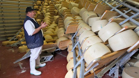
The agricultural area shown above is an area of north-central Italy that usually does not experience earthquakes. On May 20, however, it experienced a 6.0 quake, with several modest aftershocks following.

Compared to other quakes that have been in the news in recent years, this was relatively small and casualties, though tragic, were few. Seven people died in the quake -- four while working in ceramic or food factories, many of which were damaged and three from fright-related medical problems.

More than $250,000,000 was lost in agricultural products, a lot of it in a surprising way. The area is known for its cheeses. You can use Google maps above to find the distance from the epicenter to the city of Parma, known for a famous cheese that may be in short supply for the next while. Because fine cheese are aged in large wheels, the earthquake in a few seconds damaged up to two years worth of production.

Tens of thousands of wheels -- each weighing more than 80 pounds and worth over $500 -- were damaged. Some might be salvaged, but exposure to air means that mold will ruin most of the cheese before it can be repackaged.

Photo: ABC News / AP
To view recent earthquakes visit the Real-time Earthquake page operated by USGS. It can be set to update automatically. In fact, while I was writing this article, a magnitude 4.5 earthquake struck Greece, and the map was updated with many details.

Monday, May 21, 2012

Rings of Fire

Photo: National Geographic
EarthView participants often hear about the Ring of Fire, referring to the 25,000-mile-long corridor of volcanic and tectonic activity surrounding the Pacific Ocean. This week, both the terrestrial Ring and a celestial Ring have been in the news. The aptly named Fuego volcano erupted near Lake Atitlan in Guatemala, and a rare annular eclipse was visible from eastern Asia through the western United States.
Photo: redOrbit
For maps showing the path of every eclipse from 1901 to 2100, see the NASA Eclipse page. For current information about volcanoes within the United States and its territories, see the USGS Volcanoes page.

Tuesday, May 15, 2012

Living in the Ring of Fire

Kawaakibb is the screen name of a blogger living in Jakarta, the capital of Indonesia. On October 26, 2010, two major disasters struck her country at the same time, as the volcano Mt. Merapi erupted and an earthquake led to a tsunami striking the Mentawai archipelago. This led her to write Living in the Ring of Fire, which combines some basic geology with her personal experience of growing up near the intersection of three tectonic plates (or four -- the Philippine Plate is often considered part of the Pacific Plate). A more detailed description and useful maps can be found in Professor Robert Hall's article Indonesia, Geology.

Tuesday, May 8, 2012

BC Tent Saves the World

All better now!
During our recent visit to the State House, the EarthView team noticed a bit of a problem. Only two things can really go wrong with EarthView -- the fan and the zipper. We always travel with a spare fan, but a zipper is a not easily replaced! Fortunately, one of our geography students has learned watch repair in her family's shop, and working with small gears is close enough to working with zippers that she was able to keep EarthView working. The next day, we managed to open and close EarthView a few more times during a short program at the Howe-Manning School in Middleton.

As soon as we became aware of the problem, though, we knew that the real solution was to call BC Tent in Avon. Shortly after acquiring EarthView, we had taken it there for a bit of upkeep and patching, and for a zipper. Most of our 35,000 visitors have passed through EarthView's Prime Meridian since then, so it was time for a replacement. This is not an ordinary bit of sewing, nor does anybody keep this kind of zipper on hand. But BC Tent got to work right away, making sure we would have the zipper in place without losing any program time. We were also glad we could count on our team behind the scenes at BSU -- Kathie Manning, Dr. Diana Jennings, and Fred Clark -- to make sure this worked out seamlessly.


Even BC Tent's huge workshop is not big enough for a traditional EarthView photo op. CEO Bob Costa and general manager Rhona Dias did proudly pose with EarthView when it was all patched up and ready to start touring again. Not pictured is the real hero of the moment -- BC Tent's technician and fabric magician Edson, who also made that bag that -- amazingly -- holds a 20-foot globe. Their team's advice to our team: periodic zipper maintenance with beeswax!

Horace Mann Middle School, Franklin -- May 11

42° 05' 28" N
71° 24' 22" W 
Learn more about Lat/Long (including how to look them up by address)
Also, compare today's coordinates to those of other recent EarthView outings, near and far!


The EarthView Team is making its first visit to the Horace Mann School in Franklin. 
View Larger Map

Both Horace Mann and the BSU home base of are both located along Boston's "outer ring road" of I-495. Because Boston is so close to the Atlantic Ocean, this outer ring is not actually a loop, but rather connects Cape Cod and Cape Ann with all of the other places that are a similar distance from the city.

The middle school and the university have something else in common in the person for which the middle school is named. Bridgwater State University was co-founded by Horace Mann, though under a different name, in 1840. He was an early leader in public education, and helped to create Bridgewater as a normal school, which is a school specifically for the training of teachers. A beautiful auditorium named in his honor is still one of the best rooms on the BSU campus for public lectures and concerts, and its recent renovation preserved the paintings of the Muses that adorn its walls. We hope that Horace Mann Middle School students have an opportunity to visit Horace Mann Auditorium on the BSU campus some day. Photographs do not really convey just what a beautiful tribute it is to the importance of the arts in Horace Mann's vision of education.

"The teacher who is attempting to teach without inspiring the pupil with a desire to learn is hammering on cold iron."
The EarthView visit follows the Horace Mann Middle School's first-ever Family Geography Night, during which parents and siblings have the opportunity to learn geography alongside their students. This follows successful Family Geography Nights in Braintree and North Andover.

Our visit takes place on May 11, which is the anniversary of several events with a geographic connection.


On May 11, 2011, In Nepal, Sherpa Apa Sherpa achieves a new record by climbing Mount Everest for the 21st time
On May 11, 2010, The Gulf of Mexico oil spill threatened sensitive marshes and wildlife along the Gulf Coast; Admiral Thad Allan was appointed to lead the Federal response to the spill
On May 11, 1989, Kenya announced worldwide ban on ivory to preserve its elephant herds
On May 11, 1984, a solar transit of the earth could have been seen from Mars
On May 11, 1967, the 100,000,000th U.S. phone was connected
On May 11, 1916, Einstein's Theory of General Relativity presented
On May 11, 1910, Montana's Glacier National Park was formed
On May 11, 1858, Minnesota admitted as 32nd U.S. state
On May 11, 1421, Jews are expelled from Styria Austria
On May 11, 1330, Constantinople (Istanbul) becomes new capital by Roman Emperor Constantine for Eastern Roman Empire
On May 11, 330, Constantinople (Byzantium) becomes capital of Roman Empire

Sunday, May 6, 2012

EarthView on Channel 22


Many thanks to reporter Christine Lee, State House Correspondent for Channel 22 in Springfield, for her excellent report on geography education and the recent EarthView visit to the State House. Be sure to read her report, entitled Geography Lost Amid Emphasis on Other Subjects. Thanks to the teachers and the middle-school students from Barre who are featured in the report.

Thursday, May 3, 2012

Good Moon Rising


The moon exerts a gravitational pull on the waters of the earth, whether it be in plants or in the oceans. This can affect the flavor of fruits -- even coffee! -- and can certainly influence floods in low-lying coastal areas. Because we do not understand all of the possible effects of tides, people sometimes worry about the effects the moon --especially a full moon -- might have. A special full moon, such as the "super moon" expected on Saturday night, May 5, can lead to more intense concerns.

The images below compare the apparent size of the moon at perigree and apogee. Of course, the moon does not actually change size or brightness; it just looks that way to observers at the earth's surface.
As explained by National Geographic, a super moon occurs when the moon achieves its full phase at the same time it has its closest approach (perigree) to the earth in a given year. This will occur Saturday night, and in fact the two events (full moon and close approach) will occur within minutes of each other near midnight. Just as it reaches the full phase, the moon will be only 356,955 kilometers away, compared to its average distance of 384,400. The result is that the moon will appear to be 16 percent larger and 30 percent brighter than average.

Because the moon appears largest when it is near the horizon, the best time for photographers to take advantage of the "super moon" will be just after sunset, as the moon is rising. If you go out to observe the moon at this hour, notice that the sun will have just set exactly opposite of where you see the moon rise!

And finally: do not worry! The impacts of this coincidence will be limited to tides and possibly fruits!

Back to the People's House

42° 21' 30" N
71° 03' 50" W

Learn more about Lat/Long


View Larger Map

Today EarthView will be at in Nurses Hall at the Massachusetts State House. This is our fourth visit to the People's House. It is a chance for legislators, their staff members, and the general public to see the world from a unique vantage point -- inside the earth.

These visits have been planned by the Massachusetts Geographic Alliance with the help of Sen. Steven Brewer of Barre, Rep. James Murphy and Weymouth, and their staff members. Sen. Brewer and Rep. Todd Smola of Palmer -- the only geographer in the legislature -- have introduced a bill that would create a commission to study geography education in the Commonwealth.

Representative D'Amelia from Bridgewater was among the many legislators who had a chance to go inside the earth! Read more about the visit on the BSU Geography blog.

A visitor from Kenya was very pleased with EarthView and with the gift of a smaller inflatable globe.


Following our visit inside the State House, three geography majors from Bridgewater State University (home base for EarthView) use a classroom globe outside the State House to show where we were!
Global navigators Lara Joyce,  Kimberly Frisoli, and Natalie Regan.  

Tuesday, May 1, 2012

Howe-Manning School, Middleton -- May 4

42° 35' 47" N
71° 00' 51" W 
Learn more about Lat/Long (including how to look them up by address)
Also, compare today's coordinates to those of other recent EarthView outings, near and far!
 

CLICK TO ENLARGE
EarthView returns to the North Shore with a visit to the Howe-Manning School in Middleton. Located on the Ipswich River, Middleton was part of Salem prior to 1728. It is one of three towns in Massachusetts whose name begins with "middle" -- in this case because it is mid-way between Salem and Andover, which were the most prominent towns in the region at the time Middleton was founded.

The EarthView team is delighted to be bringing our giant globe to a town that has a globe right on its town seal! Thanks to a helpful librarian at the Flint Public Library for this version of the seal, and for letting us know that it was officially adopted on May 21, 1971. The script reads "Knowledge is Power," which of course it is!


View Larger Map

Middleton is now mostly a residential community, but in previous generations was known for its iron manufacturing. Middleton is also home to the oldest tree in Massachusetts. The Howe-Manning School is in a new building located in a commercial area in the center of the town and very close to the Flint Public Library.


View Larger Map

The EarthView visit takes place on May 4, the birthday of EarthView team member Dr. Hayes-Bohanan and the anniversary of a number of important events:

In 1853, Sarah Remond refused to sit in a segregated section of a Boston theater
In 1493, Spanish Pope Alexander VI divided the Americas between Spain and Portugal, even though very little had been mapped by Europeans at the time
In 1494, Christopher Columbus landed in Jamaica
In 1626, Native Americans sold Manhattan for $24 in cloth and buttons
In 1886, Haymarket Riot in Chicago
In 1961, Freedom Riders bus tour begins in the South
In 1963, the Spellman Museum of Maps and Postal History was dedicated in Weston, Massachusetts. It remains one of only two comprehensive postal museums in the United States, and is a great place for people of all ages to learn geography!
In 1970, four college students killed in Vietnam War protests in Kent State, Ohio


It also is (or would be) the birthday of Hosni Mubarak and Maynard Furgeson (both in 1928), Audrey Hepburn (1929), William Bennett (1938), and George Will (1941). Students and teachers can use Mass Moments to learn about significant anniversaries in Massachusetts history, and Brainy History for birth dates and anniversaries worldwide.

Also, a very special geography-related event will take place in Middleton on the evening of our visit. Author Robert Thorson will be speaking about stone walls at the Flint Library. He is the co-author of the children's book Stone Wall Secrets and the author of Stone by Stone and Exploring Stone Walls. As geographers, ecologists, and historians throughout New England know, stone walls can tell us a lot about prior human uses of land in our region. Almost all of the forest we find in New England today -- such as the large area just to the north of the Howe-Manning School -- was once used for farming or grazing. The walls that remain within or along the edges of such patches contain clues about what happened there decades or centuries before. Mr. Thorson's talk is primarily for adults, and begins a 7:00.

Friday, April 27, 2012

Sharon Middle School -- April 27

42° 06' 24" N
71° 09' 58" W 
Learn more about Lat/Long (including how to look them up by address)
Also, compare today's coordinates to those of other recent EarthView outings, near and far!


The EarthView team is making its first visit to Sharon Middle School, located in the town of Sharon about a forty-minute drive north of our Bridgewater State University campus. Sharon is interesting both in terms of its site (characteristics of the place itself) and its situation (relationship to other places). Fully one-third of the town's land is protected open space, including part of a state park (in which team member Dr. Hayes-Bohanan frequently hikes with his energetic little dog), a lake, a wildlife sanctuary, and town parks. These spaces provide for wildlife habitat and biodiversity; they also help to keep air and water cleaner. Because of the town's location halfway between Boston and Providence -- and its convenient connection by highway and railroad -- it is home to a diverse mix of long-time residents and relatively new residents who commute to work in those cities. Many religions -- both Western and Eastern -- are represented in the town's Interfaith Clergy Council.


The EarthView team is particularly interested in one feature for which Sharon is well-known in the region -- Crescent Ridge Dairy, from which the Hayes-Bohanan family has its milk delivered weekly. A growing number of people are becoming aware of the benefits of local food sources such as this dairy. The group will be investigating the Dairy Bar on the way back to Bridgewater. What direction will the group need to travel, and how far?


View Larger Map

The EarthView visit takes place on April 27, which is Arbor Day. A few of the many geography-related anniversaries on this date include:

1989 students occupied Tienanmen Square in Beijing, China
1989 a hurricane killed 500 people in Bangladesh, which often suffers from severe floods
1984 70 inches of snow fell in one day in Red Lake, Montana
1965 the Pampers disposable diaper was patented (this had huge environmental consequences)
1961 Sierra Leone declared independence from Great Britain
1950 South Africa passed the Group Areas Act, officially segregating people by race
1861 West Virginia seceded from Virginia, after Virginia seceded from the United States
1773 British Parliament passed the Tea Act
1521 Explorer Ferdinand Magellan was killed in the Philippines

Sunday, April 15, 2012

Learning Opportunity

Geography is about more than memorizing the names of capitals and longest rivers, but knowing the absolute and relative locations of places is important. New places can then be added to our ever-improving mental maps of the world.

We recommend a variety of geographic games for this purpose, and we are particularly fond of those that combine basic location with the opportunity to make other geographic comparisons. JetPunk is a particularly rich source of geography games with many special themes, but my favorite of these is simply a challenge to list all of the countries of the world in 12:00 minutes. As the names are typed, countries are shaded (if they are large enough to be seen at the small scale of the on-screen map) and entered into an alphabetical list by continental region.

I have completed the list several times now, but usually find that I miss a couple of those that are invisible on the screen, and that I cannot place alphabetically. Last night, Tonga was one such country, so I decided to make the game a bit more educational by looking up something about it. This makes the time invested in the game easier to justify!


View Larger Map


From the U.S. State Department's Tonga background page on the I learned that the word "tonga" means "south" in many Polynesian languages, and that it is south of Samoa. It is a sovereign, constitutional monarchy, but has an arrangement with the United Kingdom for external protection. It is among the islands of the Tongan archipelago that the famous mutiny of the H.M.S. Bounty took place in 1789. The mutiny is more often associated with Tahiti, 1,300 miles to the east, where the ship had spent the previous five months and with Pitcairn Island -- even farther east -- where the mutineers settled.


Bounty Voyage

Saturday, April 14, 2012

EarthView Institute -- Part 3

On Saturday, April 14, teachers from all over Massachusetts gathered for the third and final installment of EarthView Institute, in which they have earned their "EVI Driver's Licences" that will enable them to take EarthView back to their own communities.


Prior to going back to the gym so that they could show us their EarthView skills, we had another presentation by one of the EarthView team members. BSU geography student Ashley Costa talked about the cultural geography of Brazil from the point of view of her family heritage, her study-abroad experience in Porto Alegre, and the many Brazilian communities in eastern Massachusetts. Music was involved!

We watched the beginning of Brazil's Rising Star, a 60 Minutes interview with former Brazilian president "Lula" and we also discussed the recent visit of current president Dilma Rousseff, which is discussed on Dr. Hayes-Bohanan's Environmental Geography blog.

During lunch, we discussed the cultural and political geography of music from throughout Latin America.

From the teachers participating in the Institute, we learned a lot of new ways to use EarthView, which we will be sharing through this blog and our own presentations in coming months. For example, we paid more attention to the geography of Antarctica than we often do, and we are starting to find resources with which to develop that further.

Wednesday, April 11, 2012

Today's Indian Ocean Quake


This map was copied from the web site of the Earthquake Hazards Program at 7:50 a.m. Eastern Daylight-Savings Time today. It shows the 100 most recent earthquakes at that time (some dots cover other dots). EarthView students will recognize that most but not all earthquakes occur along the Pacific Ring of Fire or other plate boundaries. Whenever I see news of an earthquake, I check the program web site for details. It is a service of the United States Geological Survey, an agency of the Department of Interior that employs geographers, geologists, and biologists to create maps and analyze the geographic distribution of minerals, water, biological resources, and many kinds of natural hazards. Because an earthquake anywhere in the world can be detected everywhere in the world, the USGS is able to provide instantaneous reports on earthquakes, even if they are far from the United States.

This morning's earthquake was in the Indian Ocean, very near the quake that caused the devastating tsunami of December 26, 2004. For that reason, the USGS information about this morning's quake links directly to the tsunami program of the National Oceanic and Atmospheric Administration, which is part of the Department of Commerce. The preliminary magnitude estimate is 8.2. Buoy observations show wave heights ranging from 0.1 to 1.0 feet, and a detailed report estimates the time that waves should arrive in various locations throughout Indonesia and other countries surrounding the Indian Ocean. All locations are indicated by latitude and longitude, and all estimated or observed times are in Greenwich Mean Time (Zulu), which is four hours later that Eastern Daylight Savings Time.

The tsunami center provides data that individual countries and localities use in deciding whether to issue evacuation orders or warnings.


Tuesday, April 10, 2012

Middle East Geography Day

Today, the Middle Eastern Studies program at Bridgewater State University welcomes students from the Bridgewater-Raynham for a series of discussions about the Middle East. This is a world region that includes parts of northern Africa and southwestern Asia. This is not an EarthView program, in that we will not be setting up the globe, but EarthView coordinators Dr. Domingo and Dr. Hayes-Bohanan are meeting these middle school and high school students to talk about this dynamic region of the world from a geographic perspective.

We share here a number of the online resources we are sharing with those students, and hope that other EarthView participants will find them as interesting as we do!

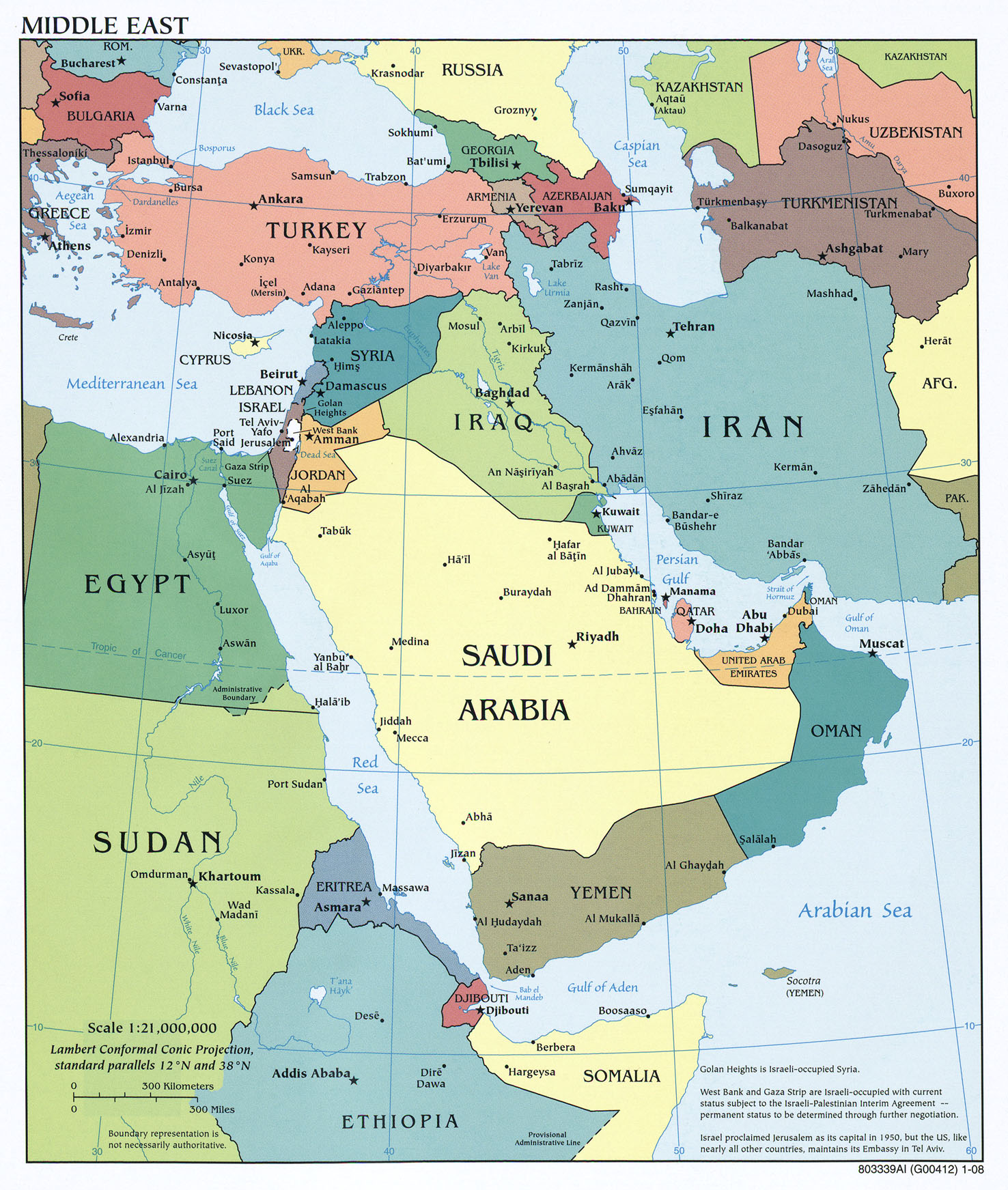
We begin with a reference map from the excellent Perry-Castañeda collection at the University of Texas-Austin. This is a great source for definitive maps for class projects, by the way. Even in this collection, however, it is clear that the term "Middle East" does not have a single, consistent definition.

The Guardian UK newspaper has published The Path of Protest -- a timeline of the protests, activities, and political changes in more than a dozen countries of the region since late 2010, when The Arab Spring began in Tunisia. Use it to follow events in any country of the region, or to see how much activity took place in any given week. We learn, for example, that today's presentation is on the first anniversary of a major protest march in the Yemeni capital of Sana'a -- where such events were previously unheard of -- that drew tens of thousands of people into the streets.
Arab Spring Timeline from the Guardian UK
Some of these activities took place in coffee shops, by the way! The first coffee shops were located in what is now Saudi Arabia, and it was nearly 500 years ago that a political leader -- the governor of Mecca -- shut down a coffee shop for the first time. The role of coffee shops in the Arab spring is included in Cafe Stories.

We also spoke briefly about the concept of orientalism, as illustrated by the use of Arab images in coffee advertising.

We can examine the geography of the Middle East -- or any other region -- using a dynamic new online atlas  called Show World, which includes dynamic cartograms that display the countries of the world whose size is shown in proportion to such variables as population, economic activity, military spending, and even coffee production! Although coffee is called Arabica because it was first cultivated in Arabia, and it is still consumed in the region, almost no coffee is now produced there. This online atlas is full of similar surprises!

We will spend part of our session exploring the new education materials from National Geographic Education.

The web site of the Newseum in Washington, DC is a great source of geographic and linguistic education. Every day, the front pages of more than 700 newspapers -- the "first draft of history" -- are displayed, just as they appear on news stands in thousands of cities throughout the world. Not only can we see what is happening, we can see what editors consider important in different parts of the world, or for different audiences in the same part of the world.

We also viewed a 5,000-year time-lapse map of the empires of the region, which ends with the formation of independent states within the past half-century or so.


As in all parts of the world, religions help to shape the human geography of the Middle East. A time-lapse of the "Big 5" religions helps viewers to understand the Middle East in the context of cultural geography at a global scale.


The physical geography of the Middle East is dominated by its dry climate, which is mainly the result of global circulation patterns that cause high pressure to dominate the region. In areas of high pressure, air is stable or descending, making cloud formation rare. This simple video depicts a simplified model of those patterns on the Western Hemisphere, but correctly indicates the factors that dominate climate in the Middle East.


The resultant climate is reflected in the desert and grassland biomes of the region.

Monday, April 9, 2012

Family Geography Night -- East Middle School in Braintree


42°13'15"N 
70°59'23"W
(Learn more about Lat/Long, including how to look up by address

We are delighted that TWO schools in Braintree have adopted the Family Geography Night concept, making it their own. These are both schools with geographic names -- South and East -- and more importantly they are schools where we encounter a lot of students with a sound understanding of the concepts of geography and an enthusiasm for learning more. Clearly, the excellent educators we have met at both schools -- and in Braintree's central administration -- have a lot to do with that. We are very pleased to be spending another evening with these educators, their students, and the families who support all this learning.

Since the EarthView Team visited South Middle School just a fortnight ago, it would be good to compare the coordinates of the two schools. Which is farther south? East? By what portion of a degree? Where would the antipodes of these schools be (See the "more about" link above for this one.)

From the town web site -- click to enlarge seal & map.
Aside from a striking name borrowed from a town in England, Braintree is a fascinating study in both history and geography. The blog post for our September 2011 visit to East Middle includes some discussion of the town's unusual seal, and also references the situation of the town. Geographers use the word "site" to refer to the characteristics of a place, while "situation" refers to the ways it is connected to (or separated from) other places or the broader region. Braintree is south of Boston, and includes one of the most important intersections in southern New England, as traffic leaving Boston is split between those headed south and east toward Cape Cod and those headed south and west toward the South Coast of Massachusetts or the I-95 corridor. Where outgoing traffic splits, incoming traffic converges. Braintree is also at the periphery of the municipal rail system for Boston, includes access to ferries (directly or through neighboring towns), and a major terminal for bus service to Logan Airport.
The convergence of these transportation networks creates a point of very high accessibility -- and therefore property value, especially commercial. This in turn has made Braintree a logical site for major office and shopping infrastructure. Combined with its role in the nation's history and the complexity of the coastal topography, Braintree is an ideal place to learn geography!

Saturday, April 7, 2012

EarthView Institute Continued -- April 7

Today we have had the continuation of the EarthView Institute, which we began last week. The EarthView team is preparing eleven teachers from throughout the state to run EarthView programs on their own.
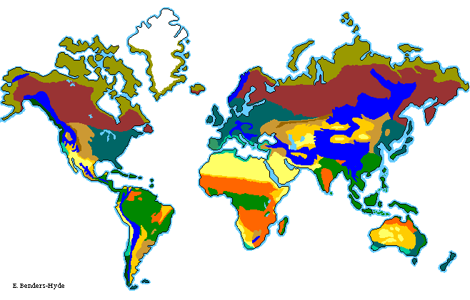
We began the day with an activity about climate classification, and discussed the relationship between climates and biomes. Once in the gym, our "Globe Wrangler" Brigitta used a small globe from the age of the dinosaurs to illustrate the movement continents resulting from plate tectonics. She later shared a lesson on the geography of Alaska, where she had lived as a child.

`

The teacher participants spent time describing their own ideas about using EarthView with their students, and they practiced caring for EarthView, inflating and deflating it.


We then spent some time in the Global Education Center, a curriculum-resource room that the Department of Geography operates in conjunction with the Massachusetts Geographic Alliance. We examined both print and online resources, including Earth at Night, GeoChron, the Kony 2012 BSU blog, and the Nintendo version of Google Maps.


We also spent some time looking at patterns of air traffic. (Note: this is an accelerated summary, not in real time.)

Saturday, March 31, 2012

Rail Car Geography


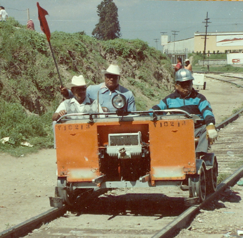
Even before seeing these fellows in Cholula in the summer of 1989, I was fascinated with rail cars as a way of exploring landscapes. I wrote about the concept, the hobby, and some lesson plans in Real Toy Trains for Wiley GeoDiscoveries.