EarthView team bios, guidelines, and more.

Saturday, March 31, 2012

Rail Car Geography


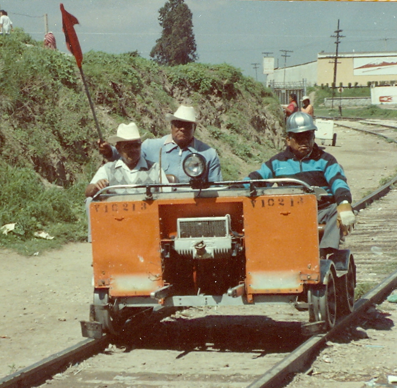
Even before seeing these fellows in Cholula in the summer of 1989, I was fascinated with rail cars as a way of exploring landscapes. I wrote about the concept, the hobby, and some lesson plans in Real Toy Trains for Wiley GeoDiscoveries.

EarthView Institute -- March 31

41°59'17"N 
70°58'21"W
(This is very close to a confluence point. See our Lat/Long post to learn more about defining locations.) 


For four years, the EarthView team has been taking our giant globe to students throughout eastern Massachusetts -- and occasionally beyond. We have been able to reach over 30,000 students directly, and to bring the excitement of geography to several dozen towns.
Young Geographer from BSU Graduate School


The team is small, however, and able to devote only one day a week to the program. Most of the time EarthView is not in use. For this reason, we are very pleased to be offering our first EarthView Institute, in which we are preparing geography teachers from throughout the state to run their own EarthView programs. 


We look forward to learning from these excellent teachers, and to giving them their "EarthView Drivers License."


View Larger Map

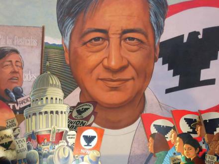
Our institute begins on March 31, the anniversary of the birth of César Chávez.

US Department of Labor Mural

What other significant events took place on this day?

Friday, March 30, 2012

Family Geography Night -- South Middle in Braintree

42°11'02"N 
70°59'53"W
(Learn more about Lat/Long) 

PHOTO By Lee Gorman. See entire set on Flickr.
This Wednesday evening, Dr. Domingo and I were very pleased to return to South Middle School in Braintree, which we had most recently visited on September 16. This time, we saw both seventh graders and their parents -- more than 100 in all -- who were participating in Braintree's first Family Geography Night. This is a model developed at North Andover Middle School that earned a commendation from the Massachusetts Senate last year. It allows parents to learn along with their students, and to see that geography is a much more dynamic field than they might recall from their own school days.
Thanks to Braintree district Social Studies Coordinator Gorman Lee for his support of geography in general, this event in particular, and the photos he provided of the evening. Thanks also to Mark Henry and the other terrific teachers from both South and East Middle (where we will be going in two weeks) who made this possible, as well as the school principal and custodians. 
And of course, thanks to the seventh graders who showed their enthusiasm for learning about the world and how they are connected to it!

Thursday, March 29, 2012

Wind Maps

WIND MAP of March 20, 2012
SEE ANIMATION
FOR CURRENT CONDITIONS
Unlike most things that move, winds are named for the direction from which they blow, because that gives some indication of what it might bring. In Bridgewater, Massachusetts, a wind from the northwest is likely to bring drier, cooler air compared to a wind from the southwest, which would usually bring air that is both warmer and moister. Other movements, such as those of a vehicle, human migration, or a herd of caribou, are named by the direction toward which they are moving.

Wind is powered by complex interactions between solar energy -- which heats the air unevenly -- and gravity. Wind is therefore a perpetual resource that humans have used for centuries to power ocean vessels for trade or sport, and also to power land-based activities. In colonial North America, it was often used to grind corn. The gristmill in Eastham on Cape Cod was built in Plymouth around 1680 and is still using wind power to grind grains. Windmills are associated with the Dutch, because wind power has been used to pump water out of the Netherlands for well over a thousand years. In fact, there would be no Netherlands without them!

Wind is a perpetual resource, meaning that it is always available, whether humans use it or not. Renewable resources are those that can be used indefinitely, as long as they are not overused, while non-renewable resources become less available every time they are used. Because it is perpetual, wind is potentially very valuable, but it also varies in strength from place to place and over time. For that reason, people are investigating the geographic patterns of wind in order to find the best places to harness wind energy.

One result of this work -- combined with internet technology and some clever programming -- is Wind Map, an animated page that allows people to visualize the wind conditions in the United States, almost in real time. The gallery shows how much these patterns can change from day to day. This is a very new effort; the programmers are currently looking for sources of data that would allow them to create a similar visualization for the entire world.

Important: Comparing these patterns to national weather maps, one will notice that the wind directions do not correspond exactly with weather patterns and the movements of fronts and storm systems. This is because ground-level winds are measured at 1.5 meters above the surface, whereas weather systems are moved by winds much higher in the atmosphere that are not influenced much by friction and can be strongly influenced by the Coriolis effect.

Wednesday, March 21, 2012

Wilmington Middle School -- March 23

42° 32' 51" N
71° 11' 17" W 
Learn more about Lat/Long (including how to look them up by address)
Also, compare today's coordinates to those of other recent EarthView outings, near and far!


Movement is one of the five major themes of geography, and the town of Wilmington's situation has given it a very special place in the movement of goods, particularly between the Merrimack River and the city of Boston. From 1803 to 1852, the Middlesex Canal carried many products through the town, including hops and later textiles. In 1835, the Boston and Lowell Railroad opened, also passing through Wilmington, and leading eventually to the closing of the canal. Operating under various names, this is now the longest-running railroad in the United States, and continues to carry freight and commuters through the town.

The railroad, of course, is still quite evident as it passes through the center of Wilmington. The canal, abandoned 160 years ago, is no longer visible, but for the most part it ran very close to the railroad (see the Map Book from Middlesex Canal Commission to see if your house is near the old canal). One place where the canal was a bit further from the tracks is the wooded area shown below. The neighborhood to its south has two toponyms -- Towpath Drive signifies the path along the canal for towing barges by mule, while Apple Tree Lane may be related to Wilmington as the home of the Baldwin apple variety.


View Larger Map

During our EarthView visits, we sometimes mention events of geographic significance that have occurred on the same date as our visit. For the Wilmington visit, one of those events is occurring on the exact day of our program. The European Space Agency will be launching the first of a new kind of rocket from its Spaceport in the extreme south of France. In fact, the space station is being resupplied from Kourou, which is in a part of France most people do not realize is in the country. The Globe Lady is a native speaker of the French language who taught French before becoming a geography teacher. She will be highlighting this special part of France. Our French Prince blog post includes links to a map, a story, and music from French Guiana. This department of France was the original destination of Katie Spotz in her Row for Water project in 2010, though strong currents there forced her to land in Guyana instead.


Also on March 23 ...


In 1965, the United States launched Gemini I, sending two people into space for the first time.


In 2010, President Obama signed the new health-care law.
In 2002, girls in Afghanistan went to school for the first time in many years.
In 1983, President Reagan proposed the Strategic Defense Initiative, known as the "Star Wars" proposal.
In 1982, General Rios Montt took over the government of Guatemala in a military coup.
In 1964, the first UNCTAD meeting was held in Geneva. The United Nations Conference on Trade and Development has been held a dozen times, with UNCTAD XIII coming up this April. The first UNCTAD led to the creation of the Group of 77 a few months later.
In 1957,  the US Army sold its last homing pigeons, though the Coast Guard did try using them again on a trial basis. Pigeon racing continues as an active -- and very geographic -- hobby in the United States and elsewhere.
In 1956, Pakistan became the world's first Islamic republic.
In 1950, the United Nations World Meteorological Union was formed.
In 1948, Jack Kerouac of Lowell (very close to Wilmington) wrote his first novel, which was published two years later. He became his home city's most famous writer, and his later work On the Road popularized the idea of the "road trip" -- an informal kind of long-distance geographic exploration.
In 1942, the U.S. began moving 120,000  Japanese-Americans from western states into interment camps elsewhere in the country. (An official apology came in 1988.)
In 1933, the German Reichstag gave Adolf Hitler power through its Enabling Act.
In 1919, Benito Mussolini began his fascist movement in Italy.
In 1912, the Dixie Cup was invented, the start of a century of increasingly easy access to disposable products.
In 1909, former president Theodore Roosevelt began a safari in Africa, sponsored by the Smithsonian Institution and the National Geographic Society.
In 1857, Elisha Otis had his first elevator installed in New York City. This started a change in the geography of cities that continues to this day, since it allowed for previously impossible densities of population to be achieved.
In 1806, Meriwether Lewis and William Clark, having reached the Pacific Ocean, began their return journey toward the East.
In 1775, Patrick Henry is said to have declared, "Give me liberty, or give me death!"

And finally: 
Although it did not happen on March 23, the first day of spring -- the vernal equinox -- took place earlier this week, at 1:14 a.m (Wilmington time) on Tuesday, March 20. John Roach of National Geographic explains why the days were already slightly longer than the nights by the time the equinox occurred.
Mediterranean Winds

A crossword puzzle clue recently led me to learn that "Sirocco" is the name given to an occasional wind that blows from Northern Africa, across the Mediterranean, toward Europe. It is a southeasterly wind, meaning it blows from the southeast. Geographers name winds according to the from direction, because this usually indicates something about the air it brings -- warm or cool, wet or dry.


We do not often link to Wikipedia articles, but the Sirocco entry is an example of an especially good use of a hyperlinked encyclopedia. The article describes the effects of the wind and lists its name in several languages, according to the places it occurs. It also links to similar articles about the other recurring winds of the region, and to an alphabetical listing of articles about local winds throughout the world.

Note to teachers: This could be a lesson plan that practically writes itself!

Tuesday, March 20, 2012

French Prince

5° 10' N
52° 41' W 
Learn more about Lat/Long (including how to look them up by address)

The Spaceport of the European Space Agency (ESA) is located in France and South America! How is this possible? French Guinana has been a department (state) of France since 1946, and was a French colony off and on for nearly two centuries before that.

Kourou is much better suited as a rocket-launch site than is the European part of France; several geographic reasons for this are explained on the ESA web site. The launch site is in the news this week because a new kind of robotic cargo rocket will be launched from French Guiana to the International Space Station on Friday, March 23.

Of course, there is a lot more to French Guiana than just rocket ships, so the radio program The World took advantage of this week's news to explore some other aspects of its geography. Prince Koloni is not an actual prince, but he is actually French -- a musician from French Guiana who once worked on gold boats that pollute its rivers, and now uses music to help people learn to appreciate the beauty and importance of his country's forests. You can listen to his story and before watching his music video below.

Wednesday, March 14, 2012

Happy Pi Day


The earth is round, and so is EarthView! Actually, the earth is a very slightly oblate spheroid, but it is more than 99 percent round. EarthView is flat on the bottom -- Antarctica is the only continent that is not hand-painted -- so that we can walk inside.

See last year's Pi Day post for some pi-related EarthView challenges. You can also visit the commercial Pi Day web site for the first million digits of pi and some other fun information.

Monday, March 12, 2012

Littleton Independent Coverage

The EarthView team really enjoyed our recent visit to Littleton, which the Littleton Independent covered both on the front page of the next week's paper and with a short video clip on its web site. Listen to the Globe Lady explain some of the reasons for differences in movement and accessibility in China, compared to the United States.

Thursday, March 8, 2012

Vexillology Map

EarthView students notice that Drs. Domingo and Hayes-Bohanan often wear similar -- though not identical -- neckties for our EarthView programs. Often a student will point out a flag on one tie or the other, exclaiming that is represents the home country of the student or a family member.
At the geography national meeting in 2010. Note the ties!
With us is Dr. Kristin Alvarez (since deceased), an energetic teacher
who taught geography education at Keene State University, NH.
The study of flags is known as vexillology, and as much as we enjoy learning about them, we have to be honest -- we do not know nearly as many flags as we would like. Some of the quizzes on our Geography Games page are good for testing one's knowledge of flags.

We also particularly like the interactive world map of flags from ChartsBin, a web site with thematic world maps on many topics. For the screenshot below, I hovered over South Africa, home of Dr. Domingo and the only country in the world whose flag was chosen by a democratic process. This can be done for any country or territory of the world -- hover over it and see both the flag and the story behind the flag.

EarthView Visit to Littleton

Last week the EarthView team had a very enjoyable visit to Littleton Middle School, where we were particularly impressed with how much the sixth-grade students there understood about political geography and the complexity of some international boundaries.

Becki Harrington-Davis covered the visit for the Littleton Independent, which ran a cover story about EarthView and geography education this week, under the clever title "An insider's perspective."

Elmwood Street School -- March 9

42° 11' 10" N
71° 46' 19" W 
Learn more about Lat/Long (including how to look them up by address)
Also, compare today's coordinates to those of other recent EarthView outings!


View Larger Map

The EarthView team is very happy to be visiting the Elmwood Street School in Millbury. Whenever we visit a school, we try to learn a little about the local geography. The EarthView team is very impressed that the town of Millbury includes its latitude and longitude prominently on the town web site! The site then describes Millbury's central situation in Massachusetts and its links by highway, rail, and air.

As the name implies, Millbury is an historic mill town, one of many whose original industries were powered by the Blackstone River. Many of the paths that were once used for horses to tow barges along the Blackstone Canal are now being converted to bicycle paths that residents of Millbury can use to bike north and south from the town.

One very special thing about the Elmwood Street School is that one of our current geography students at Bridgewater State University was once a student there! Nikki has taken many geography courses and has traveled as a student to Tanzania, Nicaragua, Belize, among other places.

Today's visit is on the one-year anniversary of a tragedy related to plate tectonics: Japan's worst earthquake took place one year ago, creating a tsunami more powerful than anyone had predicted.

Wednesday, February 29, 2012

Littleton Middle School, March 2

42° 32' 32" N
71° 29' 14" W 
Learn more about Lat/Long (including how to look them up by address)
Also, compare today's coordinates to those of other recent EarthView outings!


View Larger Map


The EarthView team is pleased to be making its first visit to Littleton Middle School. We have never had the privilege of visiting this school, but we have passed within a few hundred feet of the school many times, as it is located very close to Boston's outer ring road, I-495. We are very pleased to see that EarthView has been included on the school and district calendars.


We know it will be an enjoyable and learningful (we know that is not a real word) day!

We noticed from the schedule that sixth-graders will be coming to EarthView from several different classes, including math, science, foreign language, and social studies. We thank all of those teachers for their cooperation, and assure them that we can connect EarthView to all of these and more. Members of the EarthView team have visited well over 50 countries, and among us we speak about a half-dozen languages, for example, and with Pi Day coming up, a lot can be done with EarthView and math. And of course geography is both a natural and a social science, as well as an art.

The EarthView team is particularly energized this week, as we welcome the Globe Lady back from some tropical travels, Dr. Domingo and Dr. Hayes-Bohanan have recently attended the Association of American Geographers Annual Meeting in New York City, and several members of the team spent last Friday at the Map Center of Boston Public Library and the Mapparium in Boston's Back Bay.


Littleton is known as the earliest commercial producer of apple juice, which remains an important product today. This is appropriate, since Littleton is 15 miles east of Leominster, the birthplace of John Chapman, better known as Johnny Appleseed. Located at the edge of a major apple-producing area -- and between that area and thousands of potential customers in Boston -- Littleton was an ideal place for a vinegar factory. Eventually, juice became a preferred product from the same raw material.

In late 2011, Hurricane Irene was followed by an unusually heavy snow storm a couple months later. One results is that many trees have been damaged or lost, and the community understands the value of trees for their beauty, providing cleaner air, moderating winds and temperatures, and providing habitat for birds and other wildlife. For all these reasons, the town is replacing many trees free of charge through a special program this spring.


Our visit to Littleton takes place at the end of a week of tragic damage done by tornadoes in the United States. The majority occur in the United States. Tornadoes can only develop where cold fronts advance into warm, moist air. This is most likely in mid-latitude locations where cold, dry air from polar regions can meet warm, moist air from tropical regions.

The National Severe Storm Laboratory is part of the National Weather Service that studies tornadoes and other rare, extreme weather events. Geographers and other scientists there have created a Tornado Education page with more detailed information about what we know -- and are still learning -- about these powerful storms. Tornadoes can occur at any time of year, but those that occurred this week were considered unusually early. Tornadoes are most likely at whatever time of year cold and warm air are both available, so that they tend to shift toward the north over the course of a year.


Our visit is on March 2, which marks several interesting anniversaries.
(I usually list 3 or 4, but March 2 is an especially busy day, apparently!)


1904Theodor Geisel, (known as Dr. Seuss) was born in Springfield, Massachusetts
This birthday is marked by Read Across America Day, as described by librarian -- and honorary geographer -- Pamela Hayes-Bohanan.

1776Americans begin shelling British troops in Boston -- four months before Declaration of Independence
1799Congress standardizes U.S. weights and measures helping to unify the young country
1807Congress bans slave trade effective the following January. Slavery continued for almost 60 more years, based on existing slaves and their children and grandchildren.
1819U.S. passed its 1st immigration law
1819Territory of Arkansas organized
1853Territory of Washington organized after separating from Oregon Territory
1861U.S. creates Dakota and Nevada Territories out of the Nebraska and Utah territories
1867Congress passed the 1st Reconstruction Act
1867U.S. Congress creates the Department of Education
1896Battle of Aduwa, Abyssinia (Ethiopia) defeats invading Italians
1925Nationwide road numbering system and U.S. shield marker adopted
1933Most powerful earthquake in 180 years hit Japan
1937Mexico nationalizes oil
1939Massachusetts Legislature vote to ratify the Bill of Rights - 147 years late
1946Ho Chi Minh elected president of North Vietnam
1956Morocco tears up the Treaty of Fez, declares independence from France
1962Wilt Chamberlain became the only NBA player to score 100 points in a single game. Some credit this as beginning of the rise of African Americans star athletes in the United States.   
1970American Airlines' 1st flight of a Boeing 747
1970Rhodesia becomes independent republic (now known as Zimbabwe)
1983Compact Disc recordings developed by Phillips and Sony introduced
1983Final episode of M*A*S*H; 125,000,000 viewers

Wednesday, February 22, 2012

Chocolate Family

With cacao in Nicaragua
At EarthView presentations, I sometimes mention that I spend a lot of my time teaching and learning about the geography of coffee. Everything that is produced in some places and consumed in others has a geography, and coffee is just my favorite example among many.

Because chocolate is much more popular than coffee among our elementary and middle-school audiences, I sometimes mention cacao, the fruit from which chocolate is made. Yes, chocolate and coffee are both made from fruits. They share a lot of other geographic characteristics, often growing on the same mountains in the Tropics.

I always mention that although they are similar, cacao and coffee are not from the same family. During our most recent visit to the Richardson School in Easton, a very sharp fourth grader asked a good question: "If coffee is not in the chocolate family, what is?" This blog post is to fulfill my promise to find out, for I had never before thought to check!

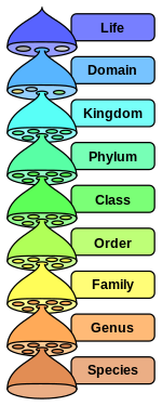
To begin the answer, we should identify each plant. Cacao is a single species from the genus Theobroma; its Latin name is therefore Theobroma cacao. (Wikipedia is not a source I usually recommend, but its coverage of Linnean taxonomy is informative and easy to navigate.) A close relative in the same species is cupuaçu, which is native to the Amazon rain forest. Many of my friends in the Amazon have cupuaçu trees in their yards -- I have enjoyed climbing the trees and eating the fruit, though its flavor is a little bit unusual.

Coffee is a bit more complicated, as two different species of the Coffea genus are produced commercially. About 70 percent of coffee is Coffea arabica, which was the first to be identified and which has the higher quality. About 30 percent is the robusta variety of the species Coffea canephora, which is almost always known simply as robusta. This is higher in caffeine and lower in quality, but easier to grow.

So what about the families? The Theobroma genus is part of the family Malvaceae, which includes some surprising cousins. One relative is the kola nut of tropical western Africa, which contains caffeine but is only sometimes used in cola soft drinks. Another is the extraordinary Baobab tree, which can live for up to 4,000 years! Most surprising to me, though, are that cotton and okra are also family members.
Baobab painting, Pew Gardens
Coffea is part of the Rubiaceae family, one of the largest families of flowering plants (any plant with a fruit has a flower). Its name derives from the word rubia for red, and the family includes chinchona, from which quinine is produced, and gardenia flowers.

The species of these two families are found throughout the world, mostly in tropical or other frost-free environments. Even those that are closely related may be native to different continents, evidence of the geologically recent emergence of the Atlantic Ocean between Africa and the Americas.

Friday, February 17, 2012

H.H. Richardson School, Easton -- Feb. 17

42° 03' 24" N
71° 06' 26" W
Learn more about Lat/Long (including how to look them up by address)


The EarthView Team is very pleased to be returning to H.H. Richardson in Easton, where we know students enjoy learning geography! The geography of Easton is interesting in a couple of ways. Like Bridgewater, Easton was once famous for making tools from local iron deposits. The same iron that give cranberries their red color was once considered a valuable resource for making tools in both towns, until bigger, purer deposits of iron made it more efficient to produce tools in other parts of the United States, and eventually in other countries.


Easton is also well known in this area for confusion about its name. Easton has only one town government and one official name. It is often thought of as two towns -- North Easton and South Easton -- though no map shows the line between the two.


Today's EarthView visit takes place on some interesting anniversaries.


It is the 49th birthday of geographer and basketball star Michael "Air" Jordan. He decided to major in geography after traveling to Venezuela for a basketball tournament in 1983. He went on to become one of the most famous geography students ever, along with Mother Theresa.

On this date in 1897, the National Congress of Mothers met for the first time. It later became the National Parent Teachers Association - PTA.
On this date in 1947, the Voice of America began radio broadcasts into the Soviet Union.
On this date in 1964, the U.S. Supreme Court ruled that all Congressional districts needed to contain approximately the same population. This affects how Congressional districts are chosen each ten years.
On this date in 1972, U.S. President Richard Nixon visited China, ending 25 years of isolation between the two countries.
On this date in 2002, the Transportation Security Administration was put in charge of airport security in the United States.

Monday, February 13, 2012

Straits of Hormuz

A lot of questions in history and politics are best understood through the lens of geography. Matt Rosenberg explains a geographic consideration that strongly influences how the United States and other industrial countries relate to Iran. The strait of Hormuz is a 21-mile wide passage shared by Iran and Oman, but a two-mile-wide channel within that strait has great importance for the entire world.

Nuna - Rodinia - Pangaea - Amasia

The interior view of the planet makes EarthView an excellent place to learn about plate tectonics. The plate boundaries shown inside highlight zones of convergence such as the Pacific Ring of Fire and zones of new creation, such as the Mid-Atlantic Ridge and the African Rift Valley. We can see that when two continental plates collide, as the Indian subcontinent continues to do with the rest of Asia, impressive orogeny (mountain-building) can result.

What we see now is a result of the greatest break-up since the Beatles (actually, it predates the Beatles by quite a bit) -- the transformation of the Pangaea into Laurasia and Gondwanaland, and eventually into the continents we know today.

This leads many EarthView visitors to ask, "What's next?" In other words, will the continents eventually drift into each other again, or will they all be subducted into the mantle? None of us will be around to see the answer, of course, but Ross Mitchell at Yale posits that 100,000,000 years from now, Amasia will coalesce around the present North Pole. If so, it would be the fourth supercontinent to form at roughly a 90 degree angle away from the most "recent" one, as Nuna, Rodinia, and Pangaea have in the distant past.

Saturday, February 11, 2012

Spellman Stamp Museum

See Gatehouse News story.
This pair of stamps is a wonderful example of the geography lessons that can be explored with stamps. Some places are made significant by the monuments that people erect, and the two shown in this image are among the best-known in the United States. They are framed in this view by cherry trees that were a gift to the United States from the country of Japan. The annual blossoming of the cherry trees draws visitors to Washington DC in the spring of each year, reminding us of the connections between the two countries, and of the similarity of climates between the Mid-Atlantic region of the U.S. and much of Japan.

The Spellman Museum of Stamps & Postal History is full of lessons of this kind. The museum opened on the campus of Regis College in Weston on May 4, 1963. It is one of only two dedicated stamp museums in the United States, the other being part of the Smithsonian Institution. Cardinal Spellman built an impressive  stamp collection through his own travels and gifts from church members and friends.

The museum built around that personal collection now serves thousands of visitors each year. The Spellman Museum's education programs provide insight into the history of stamps and postage systems, as well as general education on geography and many other subjects. With both permanent and changing exhibits, the Museum is an excellent destination for field trips and repeat visits, as the Gatehouse News recently reported.

Friday, February 10, 2012

St. Mary's School, Taunton -- Feb. 10

N 41°54'21"
W 71°05'39"
Learn more about Lat/Long (including how to look them up by address)


The EarthView Team is pleased to be visiting St. Mary's Primary School in Taunton, just a few miles southwest of our campus. We enjoy and appreciate this school, which enthusiastically includes geography at every grade level in its curriculum.

St. Mary's is in the heart of the City of Taunton, near the famous Taunton Green, a classic New England Town Common. Taunton is known as Silver City, for its historically important silversmith industry.

Friday, February 3, 2012

Stanley Elementary, Waltham -- February 3

N 42°22'04"
W 71°15'08"
Learn more about Lat/Long (including how to look them up by address)

The EarthView team is making its first visit to the Stanley School in Waltham, and we are pleased be arriving during a very exciting time for the school. Artist in residence Joshua Winer is working with the entire school on a mural, and we will be delighted to see this work in progress.