EarthView team bios, guidelines, and more.

Friday, April 4, 2014

Town of Barnstable

41° 39' N;  70° 17' W
Learn more about Lat/Long (including how to look them up by address)


View Larger Map

Climate Change

This Saturday, the EarthView team is visiting the town of Barnstable for a teacher-development workshop, and to talk about climate change. One relevant consequence of climate change is increased risk of coastal erosion.

Barnstable has been affected by erosion, especially because of Hurricane Sandy. Beaches in Barnstable and along the cape, were destroyed by Hurricane Sandy, and a lot of them look like the picture above. People have been coming together to clean up their beaches and prepare for the future, for when something like Sandy happens again.


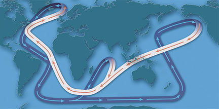
Because understanding climate is an important first step in understanding climate change, the workshop will include a discussion of factors that influence the present distribution of climate zones and biomes. Our Cape Cod location is also an ideal place to focus on the importance of ocean currents in shaping climate. It is because of the currents that important differences in marine life are found on the north and south sides of the peninsula, just a few miles apart. 

EarthView is an ideal place to visualize the thermohaline circulation, otherwise known as the ocean conveyor belt. Learn more about the conveyor belt from Woods Hole Oceanographic Institute  

Massachusetts Geography Bee -- Worcester Academy, April 4

42° 15' 07" N
71° 47' 28" W 
Learn more about Lat/Long (including how to look them up by address)

EarthView will be resting this Friday, as some members of the team help to officiate the National Geography Bee. For the second year in a row, the Massachusetts portion of the event is proudly hosted by Worcester Academy. It is fitting that the event has returned to the Academy, one of whose graduates was an early president of the National Geographic Society and the first editor of its magazine.


The Bridgewater State University Department of Geography is supporting the event with a couple of maps. Dr. Boellstorff printed out a beautiful map of the state that will be on stage, with an opportunity for each participant to "pin" their hometown. Meanwhile, BSU student Jason Covert prepared the map below, based on registrations for the bee.


As Bay State participants are all aware, last reigning National Geography Bee champion is Sathwick Karnik of Plainville, Massachusetts. He and his family have been with EarthView several times during his victory year! Just as Sathwick met Alex Trebek at the final round last year, today's winner will meet Soledad O'Brien when she debuts as host this May.

Friday, March 28, 2014

Glover School, Marblehead: March 28

42° 29' 24" N
70° 52' 49" W 
Learn more about Lat/Long (including how to look them up by address)
Also, compare today's coordinates to those of other recent EarthView outings, near and far!


Marblehead harbor. Image: Marblehead.org
The EarthView team is very pleased to be visiting the second and third graders at Glover School in beautiful Marblehead, a town on the Atlantic coast about 18 miles north of Boston. The town is famous for all kinds of nautical activity. It is an important place in the history of both the Navy and the Marine Corps, and fishing has been important here for centuries. It is also a favorite destination for people who just enjoy boats!


The nautical activity of Marblehead reminds us of the beautiful nautilus shell. The sizes of the chambers are described by the numbers in the Fibonacci Sequence: 1, 1, 2, 3, 5, 8, 13, 21, ...

Geographers are very interested in signs of what we call "sense of place." These are the ways that people represent characteristics that make their home regions unique or special. The town seal of Marblehead shows that boating -- and specifically boating related to fish -- is important to the town. Glover School includes a beautiful image of the seal in bronze. It shows a man fishing in a dory -- a small rowboat very commonly used for cod or pulling lobster traps. The Glover School displays this local seal -- along with the Massachusetts state seal -- right outside its library. It was recovered from the original 1906 school on the same site.

The Glover School is celebrating its namesake through the creation of mosaic honoring General John Glover. Because he was a whaleship captain as well as a military officer, students and teachers decided to pose the general with rowing oars. EarthView team member Dr. Hayes-Bohanan was very excited to see this, since whaleboat rowing is one of his favorite hobbies.

The mosaic border names many virtues, such as respect, curiosity, and perseverance.

During our visit, we noticed that the second and third graders at Glover know as much about world geography as many junior high or high school students. Indeed, they tend to know more than many adults! In addition to excellent teaching and the involvement of parents with international experience, we learned that each second-grade classroom has a world map as a class rug. This map shows no political boundaries, but dots in some countries are color-coded to the flags around the perimeter.

Like the city of Quincy to the south of Boston, Marblehead is a location where granite is found at the surface. The Naumkeeg tribe called it Massebequash, which is also the name of the river that separates it from the city of Salem. English settlers renamed it Marblehead because they thought the granite headlands (seaside cliffs) were made of marble.


Our visit to the Glover School took place within the first month after its opening. It is on the site of a former school, and one of the few things that was kept is this granite outcropping. It is smooth enough that generations of students have used it as a natural sliding board. The smoothing was done during the Pleistocene Era, as a massive glacier scraped over the area. Boulders being carried under several thousand feet of ice scoured the stone like sandpaper!

On this date ...


It was 50 years ago today that the strongest earthquake ever to occur in the United States struck in Prince William Sound, Alaska. The 1964 Great Alaska Earthquake measured 9.2 on the Richter Scale and was the second-largest quake ever recorded. On the map above from the USGS Earthquake Hazards Program,  the purple line shows where the Pacific Plate meets the North American Plate. The center of the earthquake was far below the surface. The epicenter (the place on land directly above the center) was in beautiful Prince William Sound. Damage from this quake included landslides, a tsunami, and the displacement of the land surface up to 11.5 meters (almost 40 feet) above its previous elevation, or 2.5 meters below where it had been. 

As with all of the world's most significant Earthquakes, this one occurred on the Pacific Ring of Fire.


Saturday, March 15, 2014

Feel the Noise

EarthView students know that we pay quite a bit of attention to the Ring of Fire, a zone of tectonic activity encircling the Pacific Ocean. Most of the planet's earthquakes and volcanoes are found in the coastal areas that comprise this famous region.

As residents of a small, quiet town in Connecticut have learned, however, earthquakes can occur very far from the Pacific. A few miles north of the Atlantic coast, in fact, earthquakes turned out to be the answer to a mystery that perplexed the people of Moodus for centuries. Yes, centuries! Moodus is short for morehemoodus, a Wangunk term meaning “place of noises.”


 According to the radio story Thunder in the Valley, unusual noises emanating from the ground in Moodus have been attributed to many possible causes, but it was eventually ascertained that very low-intensity earthquakes were responsible.

The most severe earthquake observed in Connecticut was in neighboring East Haddam in 1791, and it did create fissures and dislocate large rocks in Moodus. The most recent temblor took place in 2011, when a magnitude 1.3 earthquake startled the town.

Geographers are always interested in the ways people express what is unique about their local regions, and Moodus offers a very nice example Sports teams at the Nathan Hale-Ray High School are not sharks, lions, tigers, or falcons. They are simply the Noises!

For a time, the sports teams at Flowing Wells High School near Tucson, Arizona had a similar name: they were named the Artesians for the flowing wells that occurred naturally in the foothills of the Catalina Mountains and encouraged human settlement there for centuries. Eventually, however, the Flowing Wells athletes took on a less unusual name.

Congratulations to the Moodus Noises for their strong sense of place!

Wednesday, March 12, 2014

Malaysian Search

6°N; 104°E

Notice that these coordinates are in full degrees, without the precision of minutes and seconds we normally post for our school visits. In this case, the coordinates represent the last known location of MH370, the Malaysian Airlines flight that has been missing since Saturday, March 8.

Image: BBC -- Click to Enlarge
Most of Malaysia is found at the southern end of the long, narrow Malay Peninsula (the rest is on the neighboring island of Borneo). For this reason -- and because the plane had plenty of fuel when it disappeared, the search now includes vast areas of water both east and west of the country.

From a geographer in Brazil we learned that people all over the world are assisting in the search. In addition to planes and ships from several neighboring countries, people with computers all over the world are participating in the crowdsourced search for Flight MH370, by visually scanning some of the thousands of recent satellite images. The shear size of the area that needs to be examined means that volunteers from throughout the world may find something before it is found by searchers in the region.
Geography is essential for Search & Rescue professionals.
Image: BBC 
BBC coverage includes initial reports and latest news. Its reporting also explains the difficulties of searching in different areas of the ocean. Deep water is difficult for obvious reasons, but shallow water is also difficult because it may have more background noise from boats. As the story of this tragedy continues to unfold, it may be useful to browse the area using this map:

Friday, March 7, 2014

Sharon Middle School -- March 7

42° 06' 24" N
71° 09' 58" W 
Learn more about Lat/Long (including how to look them up by address)
Also, compare today's coordinates to those of other recent EarthView outings, near and far!
 

The EarthView team is delighted to be back at Sharon Middle School, where we have been sharing geography lessons with seventh graders as well as with students from the preschool that shares space with the school. EarthView is an exciting experience for learners of all ages!
We were especially pleased to be at Sharon Middle School while students are celebrating Upstander Day (Thursday) and Mix-it-Up Day (Friday). This is a community that pays attention to taking care of and respecting each other, and that enjoys celebrating all the many cultures that come together in the town of Sharon.

During the final class of the day we spoke briefly about the importance of the Atlantic Ocean, but did not have time to discuss it in detail. A lot of the current tension in Crimea, for example, is related to the peninsula's position relative to the Atlantic, even though is is several thousand miles away.

Other EarthView blog posts has focused on the Atlantic Ocean and Cape Verde, the Atlantic as one of the world's five oceans, the Atlantic and Port Cities. Most interesting of all, perhaps, is the Biography of the Atlantic, and the idea that people in western Europe and western Africa did not really conceive of the Atlantic as an Ocean -- even though many of them lived near it -- until they knew about the Americas on the other side.

We look forward to coming to the town of Sharon one more time this semester -- when we go to the Cottage Street School in May.

Friday, February 28, 2014

Sharon Middle School -- February 28

42° 06' 24" N
71° 09' 58" W 
Learn more about Lat/Long (including how to look them up by address)
Also, compare today's coordinates to those of other recent EarthView outings, near and far!
 

On the last day of what has been a cold and snowy month, the EarthView team is returning to Sharon Middle School, which we first visited last April. It is a cold but clear and beautiful day to visit a neighboring town. We included some of the interesting aspects of Sharon's geography in last year's blog post.

Actually, part of the EarthView team is not with us -- Dr. Domingo is at National Geographic in Washington, meeting with members of the U.S. Congress to promote more geography education across the country. Fortunately, Dr. Domingo will be able to join us next week, as we are visiting Sharon twice this season.


Image and more detailed explanation from
Weather Underground.
EarthView is an ideal place to learn about the Polar Vortex, a pattern in the upper atmosphere that is responsible for the very cold weather we have been experiencing both in Massachusetts and in some places much further to the south. A "ridge" of high pressure in the northeast Pacific Ocean pushed warm air very far north toward Alaska, resulting in Arctic air being pushed unusually far south in the center of the continent. The phenomenon of continentality makes the effect of this anomaly even greater. In the Atlantic Ocean, high pressure over Greenland has a tendency to block the flow of air from New England, causing cold air to be stalled in our region.

While some people have been very surprised by these patterns, geographers and others who study climate change have been expecting meridional flows of this kind to be more common. The prevailing winds across the United States are west-to-east, but they are never strictly straight-line flows. They are actually a kind of Rossby wave, which has some north-south deflection. The words "zonal" and "meridional" describe the primary orientation of this kind of wave.
Image: University of Arizona Geography Department
Team member Courtney described her recent trip to Durban, South Africa, which is officially known as the eThekwini Municipality. As she pointed out, Durban is a lot like South Beach or Ft. Lauderdale, a good reminder that Africa is not just what we see in wildlife photographs!


No lions or zebras in sight!
Image: Nomads Gallery
Feel free to explore Durban and the rest of South Africa on Google Maps! Don't forget that you can click "Earth" to see a satellite view.


Friday, February 21, 2014

Cambridge School of Weston

42° 23' 11"N
71° 16' 22"W
For coordinates by address in the U.S., check Stephen Morse, or use an atlas, globe, or Google Earth for other places throughout the world.

EarthView coordinator Dr. Hayes-Bohanan is pleased have brought EarthView to CSW, where his daughter is taking a course called Maps & Meaning. The art and history teachers who lead this innovative course are using EarthView as a special classroom to continue their explorations of the thinking revealed by maps.

Friday, February 14, 2014

Frolio, Abington -- February 14

See the Math!
42° 07' 06"N
70° 56' 47"W
How many degrees, minutes, and seconds away is your house? Check Stephen Morse for any U.S. address, or an atlas or globe for other places throughout the world.

The EarthView team is happy to be returning to Frolio Junior High School in Abington, just a few miles north of our home base in Bridgewater. We are blogging from campus, on a very LOVE-ly day to be in Abington, as the sun is coming out just in time for Valentine's Day.

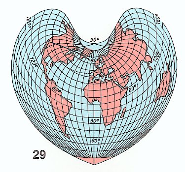
Thanks to the geographers at Bucknell University for this example of a cordiform map projection to mark the occasion.

One of the United States is actually called the Valentine State because it was admitted to the Union on this date in 1912. Take a guess, and then read all about it on Celebrating the States, one of Dr. Hayes-Boh's family blogs.


Valentine's Day is also a perfect day to talk about the Wedding of the Waters at Manaus, Brazil. This is described in some detail on a blog post for a 2009 EarthView visit in Brockton. That post includes links to further information about Rondonia, in the western part of the Amazon basin.

During our visit we also discussed the new partnership between Bridgewater State University and the University of the State of Santa Catarina in Brazil. Students from the two universities can now do extended exchanges, in order to improve language skills (in Portuguese or English) and to learn each other's countries in greater depth.

We also discussed the upcoming soccer championship in Brazil, the World Cup. We look forward to hearing about Mr. Claus' experiences as he actually attends the Cup in Rio! The games will be played throughout the country, though: learn more about the geography of the World Cup from our blog, which we will be updating during June.

We also spent some time discussing the latest major activity in the Ring of Fire -- a volcanic eruption in Java, Indonesia. Mount Kelud erupted loudly just yesterday. The eruption could be heard over 100 miles away, and ash was sent well into the stratosphere -- 12 miles into the sky. Most of the damage from this volcano is from the settling ash, which behaves something like a very heavy, dirty snow.


Monday, February 3, 2014

EarthView Spring Visits

During the winter break, EarthView made its first international journey, as part of an environmental education program in Matagalpa, Nicaragua. EarthView team member Dr. Hayes-Bohanan visits the area every year as part of his Geography of Coffee study tour.
For the first time, Dr. Hayes-Bohanan and BSU students brought EarthView to Nicaragua, where we worked with local youth to give a presentation about the environment and geography to children in Matagalpa.
Now that EarthView is back at its home in Bridgewater, it is ready to go out to schools throughout Massachusetts. The schedule may change. As of today -- February 3, 2014 -- here is where EarthView is headed:

Friday, February 7: Inly School, Scituate
Friday, February 14: Frolio Middle School, Abington
Wednesday, February 19 (evening): Franklin Middle School, Franklin
Friday, February 28: Sharon Middle School, Sharon
Friday, March 7: Sharon Middle School, Sharon
Saturday, March 8: Westfield State University
March 21: Howe-Manning School, Middleton
Friday, March 28: Grover Middle School, Marblehead
Tuesday & Wednesday, April 8-9, New England Regional Conference on Social Studies, Sturbridge
Friday, April 11: Tenney Grammar School, Methuen
Tuesday, April 15: University of Dohuk, Kurdistan
WEEK OF EARTH DAY -- PLANS ARE UNDERWAY FOR A PUBLIC DISPLAY
Friday, May 2: Oak Ridge School, East Sandwich
Thursday evening, May 8: Horace Mann, Franklin
Friday, May 9: Barnstable Intermediate
Friday, May 16: Barnstable Intermediate
Friday, May 30: Cottage Street School, Sharon
Friday, June 6: Tantasqua Regional Junior High School, Fiskdale
Friday, Jun 13: Bridgewater Middle School

Friday, November 1, 2013

Spofford Pond School, Boxford -- Nov 1

42°41'46"N 
71°01'02"W
(Visit more about Lat/Long for ideas that combine math and geography learning.)

We have enjoyed several visits to Spofford Pond School in the past, and are delighted to be back this year. It is a school that really enjoys teaching and learning geography. In fact, during our visit we are learning about a special project the sixth graders are involved in a very special project in Global Citizenship.

The project is to raise funds for a foundation named Be Like Brit, which provides education and a home for children in the country of Haiti. As Spofford Pond students know, the foundation is named for Brit Gengel, a young local woman who lost her life in the 2010 earthquake in Haiti, while working to help children there. Because the earthquake caused so much destruction in Haiti, the Gengel family decided to help the people of Haiti while also honoring the loved one they lost.

The school is being built in Grand Goâve, but the EarthView team has not yet been able to locate it on Google Maps. This can be for one of three reasons: 1) the satellite imagery used by Google has not yet been updated; 2) it is located near the town, but not right in it; or 3) we just have not looked carefully enough.

CHALLENGE: We hope that someone from Spofford Pond School can help us find the school, and provide the exact latitude and longitude so we can update this post. Whoever finds it can let us know using the COMMENTS link below this post. Hint: Look at the Orphanage Photos page on Be Like Brit for some visual clues.
View Larger Map to explore the area. How far is it from the capital city? While looking at Haiti, compare its forest cover to that of neighboring Dominican Republic. One important reason for the extreme poverty of Haiti is the destructive practice of forest removal by French colonizers over 200 years ago. 

Early on the day of our visit, an earthquake occurred at 30.298°S 71.557°W. Notice that these coordinates are presented in degrees and decimal portions of degrees, rather than degrees-minutes-seconds. Still, the information provided is enough to figure out the country where this particular earthquake took place.

ANOTHER CHALLENGE: Where was it? What ocean is very nearby?
(The answer is at earthquake.usgs.gov. Don't click until you've tried to figure it out!)

In 2010 -- just a few weeks after the earthquake in Haiti -- this South American country experienced one of the strongest earthquakes ever recorded. It caused a lot of damage, of course, but much less than had occurred in Haiti. At the time, we posted an article providing several geographic reasons that the earthquake in Haiti causes so much more damage than the one in South America. Learn more about Haiti from the Help. Hope. Haiti. blog established at Bridgewater State University in the weeks following the 2010 Earthquake.

Several times during our visit, the Globe Lady discussed tropical rain forests with several of the classes. As she mentioned, it is sometimes surprising that rain forests are actually quite difficult places for farming. Although rain and warm temperatures are good for crops, the constant rain and heat that sustains the tallest forests actually makes it difficult to grow crops. The heavy rain leaches nutrients from the soil, and the constant warmth provides an abundance of crops, many of which love to eat crops! It is sometimes surprising to learn that the most productive biome supports very small human populations. The effect is visible from nighttime satellites images, on which rain forests look mostly empty.

The great variety of species -- biodiversity -- in tropical rain forests allows them to survive in this difficult environment. No insect is interested in all of the varieties of plants, and the complex layers of vegetation and epiphytes allow nutrients to be cycled above ground -- sometimes right through the bark of trees!

As the the globe lady pointed out, rain forest biome is found in many locations around the equator, where the temperature and moisture conditions are the same. These include the rain forests of the Congo Basin, Indonesia, and the Amazon Basin. EarthView team member Dr. Hayes-Boh became a geographer because of his interest in the Amazon, and has written quite a lot about one particular part of the Brazilian Amazon -- the state of Rondonia.

We also sometimes describe the Wedding of the Waters, where the Amazon River is formed from the Rio Solimões (which is cloudy with sediment from the Andes) and Rio Negro (which is clear and dark with the tannic acids of the northern tributaries). The confluence of these rivers in Manaus is considered by many to be the start of the Amazon River, which flows so slowly that the two rivers do not mix for many miles.


View Larger Map

Thursday, October 24, 2013

Back to North Andover


The EarthView team was very please to return to North Andover for the fifth annual Family Geography Night, which has been recognized throughout Massachusetts for its success of bringing an entire community together to learn and enjoy geography!

For more information about North Andover and these programs, please see previous North Andover posts on this blog and in its archived precursor (from BSC days). Each visit has allowed EarthView to be enjoyed by more than 800 members of the North Andover community.

Friday, October 4, 2013

North Reading Middle School -- Oct. 5

42° 34' 36" N
71° 05' 17" W

Learn more about Lat/Long

EarthView returns to North Reading today, on the 56th anniversary of the Soviet satellite Sputnik. This small, simple satellite could do nothing more than send a simple "ping" message back to the surface, but the fact that the Soviet Union was able to launch it before the United States energized the space program under Presidents Eisenhower and Kennedy, eventually leading to human exploration of the moon.

Many of the tools that were developed as part of the space program are now used by geographers to learn more about the earth itself. These include earth-exploration programs such as LANDSAT, which monitors land use and conditions on a regular basis. It is also the basis for Global Positioning Systems (GPS), and for Google Maps and many other web sites that show what the earth looks like from above.

During some of the EarthView sessions today, Dr. Hayes-Bohanan described his visits with students to Cerro Negro and to the nearby volcanic islands in Lake Nicaragua. These islands are formed in a very unusual way, as each is a small piece of a large flow of lava from the nearby volcano Mombacho. Zoom out to see the relationship between the islands and the volcano. Zoom in to see the houses that occupy many of the islands. Some are the humble homes of people who earn their living fishing in Lake Nicaragua, while others are the vacation homes of some of the wealthiest families in Central America.


View Larger Map

Learn much more from our volcano roundup post.

Quashnet School, Mashpee -- Sept. 27

41° 37' 27" N70° 29' 41" W

Learn more about Lat/Long


EarthView's went to Cape Cod for its first program of the autumn season. Previous visits to Mashpee have been to the Middle School at  41° 36' 57" N, 70° 30' 34" W. Use the "Learn more" link above for ideas on how to use these coordinates for activities at home or in the classroom.
One of the great things about the Quashnet school (which has both an active web site and a frequently-updated school blog), is its labyrinth, visible here from Google Maps. 


View Larger Map

At least two members of the EarthView team completed the labyrinth, which is distinct from a maze, in that the proper route is not a mystery or puzzle. Rather, the maze provides an opportunity to calm the mind and enter a centered, balanced state that facilitates learning.


Our visit took place shortly after a new island was formed near the coast of Pakistan on September 26. This island is just about the size of a football or soccer field, and about 60 feet tall at the center. Because the internal pressure of volcanic gases is largely responsible for the emergence of the island, it may soon collapse below sea level, so that the world's newest island will probably soon be an extinct island.


Thursday, August 1, 2013

Bridge Program -- July 12 & August 1

41°59'17"N 
70°58'21"W

Usually EarthView travels in a BSU van (we dream of getting a globe-painted van some day), but for this summer's special program for middle and high school students from New Bedford and Brockton, we were able to roll EarthView to the event on its luggage cart! To our location in the Kelly Gym, we had to travel only the smallest fraction of a degree of longitude, having started in the neighboring Math & Science Center, whose coordinates are: 

N 41°59'17"  
W 70°58'19"

These EarthView presentations are part of two sessions of the Bridge Partnership, each lasting two weeks. Students come from the cities to the north and south of Bridgewater for a taste of campus life and field trips include special places in the home cities of the participating students.

EarthView team member Dr. Hayes-Bohanan lives right next to the BSU campus, but has spent a lot of time in both Brockton and New Bedford, and enjoys learning about the geography of each. The reason? Each is a local place with fascinating global connections!

Wednesday, June 12, 2013

Across Two Fridays

The EarthView Experience map includes all of the visits we have made with EarthView, but this is such a busy week for EarthView that we decided to make a separate map just to show its travels from June 7 to June 14, 2013. This busy pace has been made possible by the fact that most K-12 schools are in session while BSU is on a summer schedule. More importantly, we have relied on current, former, and future EarthView wranglers from the Geography Department, along with a graduate of our EarthView Institute who is bringing EarthView to her own school.


View Across Two Fridays in a larger map

Saturday, June 8, 2013

Continental Shifts

During our most recent EarthView presentation, as Dr. Domingo was speaking about Africa, a question came to mind for Dr. Hayes-Bohanan (who is writing this post). Noting that we always emphasize that it is a continent (when nearby islands are included) of 55 countries, the question came to mind: Where would the population of Africa rank if it were a country?

The search for information about population by continent led to a simple presentation by geohive of population changes by continent over the 1950-2050 century. As explained in our Population Primer article last year, this is the "bottleneck" century, of critical importance to the long-term balance between the population of humans and the health of ecosystems.

The shifts growth in population and the relative proportion among continents is described by this series of pie charts. The use of circles is perhaps not the best way to compare overall population, since the numbers are represented by area but the eye tends to compare diameters.


The pie charts what proportion of the population is on each continent at 25-year intervals. In reality, these are not continents in the physical sense, but major regions that make for convenient comparisons. One must look carefully to identify some of the important changes during this century. Most dramatic, is the decline of Europe's population, which has just half of the share of total population that it did only six decades ago.

The key to the charts includes Oceania, but with about one-half of one percent of the world's population throughout this century, it is not visible. How does this compare to the proportion of EarthView (and of the earth itself) occupied by these countries, which include Australia and all of the islands of the Pacific?

More About Continents

Oceania is not a continent, nor are many places in the world, though people ask geographers to assign islands to continents all the time. Geographer Matt Rosenberg addresses some of the most frequent questions that start with the words Which Continent? To understand his answer to the question about Greenland, look at EarthView or any map that shows North America and Greenland with their continental shelf.

Activities

Visit the article on geohive to see the numbers behind the charts above. Which regions have maintained their share most consistently, and which have grown the most in relation to other continents?

Experiment with other kinds of graphs -- such as bar and line graphs -- to see which are most effective at communicating the changes experienced during this period.

Finally, address the original question: If Africa were a country, what real country would be closest to it in the population rankings? 

You can answer the previous question for each continent except Asia. Why is Asia the exception?

World Cup 2014

Throughout the 2013-2014 school year, look for more information about the geography of football, which is known as "soccer" in the United States. In June and July 2014, The World Cup championships will be held in Brazil for the first time since 1950.

As most fans know, Brazil has won the Cup more often (five times) than any other country, and the game is among the country's most important pastimes. For this reason, the 2014 Cup is expected to be followed with special attention around the world. It will be an excellent time to learn more about the geography of a vast and dynamic country that has experienced many exciting changes in recent years.

Because the tournament involves many teams in several rounds, stadiums in 13 cities will be used, so that viewers of the games will have the opportunity to learn about all of the major regions of what is a far more diverse country than most people realize.

Because members of the EarthView team -- and several of the BSU alumni who have been involved with EarthView in the past -- have extensive experience in Brazil, this EarthView blog will include both academic and first-hand accounts of the geography of Latin America's largest country.

Massachusetts is home to a growing number of people from Brazil or people from the United States who have visited Brazil. The Bay State also has a growing number of economic and academic connections to Brazil, so the World Cup focus comes at a very important time for the Commonwealth of Massachusetts.


Map: Wikipedia
For now, detailed information about the Cup and its venues can be found on Wikipedia and FIFA. Return to this blog throughout the coming year!

Monday, June 3, 2013

Litterati

Some geography students who are old enough to have an Instagram account might already be in the habit of taking photographs of their food. This is the story of a father who was walking with his young children and came up with a much better -- and richly geographic -- use of the technology. This short video explains how Litterati was created, and how it can be used to help create a cleaner planet.

Wind and Water

Our colleagues at Listen Edition have posted two recent articles of particular interest to geography educators, both related to weather and climate. Listen Edition is a new blog that serves as a sort of educational concierge of stories from public radio. Teachers in any discipline can use the site for audio, lesson ideas, and in some cases, detailed lesson plans.

Map from the original
NPR Storm Surge story
The first is Storm Surge Science, which describes efforts to communicate more effectively about the geography of storm surges. As Hurricane Sandy demonstrated, the high water driven ashore by hurricanes can be among their most important effects, but many people have not known how to interpret information about the surges. Cartographers and other scientists in New York City and at the National Hurricane Center in Miami are therefore working to create maps that are more effective than the language that has been used in previous storm warnings.

The other story is not going to be directly relevant for a while, but is nonetheless interesting. Canadian volunteers stepped into freezing wind tunnels to calibrate the traditional formula for Wind Chill Factor. A new formula has resulted that more accurately describes how cold a person would fee if exposed to a particular combination of wind and temperature. This story is accompanied by a complete lesson plan.