N 41° 56' 15"
(including how to look them up by address)
The EarthView team is making its first visit to the Brennan School in Attleboro, located about 15 miles to the east of our home base on the main campus of Bridgewater State University.
BSU also has a small campus in Attleboro itself, at 11 Field Road. According to Google Maps, it is only 11 or 12 minutes away from the Brennan School by car.
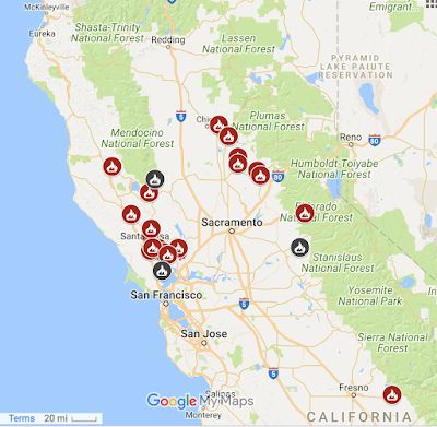
During our visit, the EarthView team will be explaining the location of the wildfires in California. This tragedy is a perfect example of geography's three questions:
Where is it?Why is it there?So what?In this case, the "where" question is a very distinctive pattern of two linear clusters along either side of California's Central Valley.
The timing and location of these fires has to do with the famous Santa Ana winds that affect California (U.S.A.) and Baja California (Mexico). As air cools at high elevations, it becomes more dense, and the high pressure forces it downhill. It becomes drier as it descends, and moves more rapidly as it is pushed through narrow canyons.
The result is that dust, smoke, and hot air is pushed down slopes, and even far out into the Pacific Ocean.
The reason that the winds come at a predictable time every year is that the global circulation of the atmosphere shifts with the sun. In New England, the most important variables from season to season have to do with temperature and the length of the day, but in many parts of the world, the direction of prevailing winds is even more important.


