42° 06' 24" N
71° 09' 58" W
Learn more about Lat/Long (including how to look them up by address)
Also, compare today's coordinates to those of other recent EarthView outings, near and far!
The EarthView team is making its first visit to Sharon Middle School, located in the town of Sharon about a forty-minute drive north of our Bridgewater State University campus. Sharon is interesting both in terms of its site (characteristics of the place itself) and its situation (relationship to other places). Fully one-third of the town's land is protected open space, including part of a state park (in which team member Dr. Hayes-Bohanan frequently hikes with his energetic little dog), a lake, a wildlife sanctuary, and town parks. These spaces provide for wildlife habitat and biodiversity; they also help to keep air and water cleaner. Because of the town's location halfway between Boston and Providence -- and its convenient connection by highway and railroad -- it is home to a diverse mix of long-time residents and relatively new residents who commute to work in those cities. Many religions -- both Western and Eastern -- are represented in the town's Interfaith Clergy Council.
The EarthView team is particularly interested in one feature for which Sharon is well-known in the region -- Crescent Ridge Dairy, from which the Hayes-Bohanan family has its milk delivered weekly. A growing number of people are becoming aware of the benefits of local food sources such as this dairy. The group will be investigating the Dairy Bar on the way back to Bridgewater. What direction will the group need to travel, and how far?
View Larger Map
The EarthView visit takes place on April 27, which is Arbor Day. A few of the many geography-related anniversaries on this date include:
1989 students occupied Tienanmen Square in Beijing, China
1989 a hurricane killed 500 people in Bangladesh, which often suffers from severe floods
1984 70 inches of snow fell in one day in Red Lake, Montana
1965 the Pampers disposable diaper was patented (this had huge environmental consequences)
1961 Sierra Leone declared independence from Great Britain
1950 South Africa passed the Group Areas Act, officially segregating people by race
1861 West Virginia seceded from Virginia, after Virginia seceded from the United States
1773 British Parliament passed the Tea Act
1521 Explorer Ferdinand Magellan was killed in the Philippines

EarthView team bios, guidelines, and more.
Friday, April 27, 2012
Sunday, April 15, 2012
Learning Opportunity

We recommend a variety of geographic games for this purpose, and we are particularly fond of those that combine basic location with the opportunity to make other geographic comparisons. JetPunk is a particularly rich source of geography games with many special themes, but my favorite of these is simply a challenge to list all of the countries of the world in 12:00 minutes. As the names are typed, countries are shaded (if they are large enough to be seen at the small scale of the on-screen map) and entered into an alphabetical list by continental region.
I have completed the list several times now, but usually find that I miss a couple of those that are invisible on the screen, and that I cannot place alphabetically. Last night, Tonga was one such country, so I decided to make the game a bit more educational by looking up something about it. This makes the time invested in the game easier to justify!
View Larger Map
From the U.S. State Department's Tonga background page on the I learned that the word "tonga" means "south" in many Polynesian languages, and that it is south of Samoa. It is a sovereign, constitutional monarchy, but has an arrangement with the United Kingdom for external protection. It is among the islands of the Tongan archipelago that the famous mutiny of the H.M.S. Bounty took place in 1789. The mutiny is more often associated with Tahiti, 1,300 miles to the east, where the ship had spent the previous five months and with Pitcairn Island -- even farther east -- where the mutineers settled.
 |
| Bounty Voyage |
Saturday, April 14, 2012
EarthView Institute -- Part 3
On Saturday, April 14, teachers from all over Massachusetts gathered for the third and final installment of EarthView Institute, in which they have earned their "EVI Driver's Licences" that will enable them to take EarthView back to their own communities.

Prior to going back to the gym so that they could show us their EarthView skills, we had another presentation by one of the EarthView team members. BSU geography student Ashley Costa talked about the cultural geography of Brazil from the point of view of her family heritage, her study-abroad experience in Porto Alegre, and the many Brazilian communities in eastern Massachusetts. Music was involved!
We watched the beginning of Brazil's Rising Star, a 60 Minutes interview with former Brazilian president "Lula" and we also discussed the recent visit of current president Dilma Rousseff, which is discussed on Dr. Hayes-Bohanan's Environmental Geography blog.
During lunch, we discussed the cultural and political geography of music from throughout Latin America.
From the teachers participating in the Institute, we learned a lot of new ways to use EarthView, which we will be sharing through this blog and our own presentations in coming months. For example, we paid more attention to the geography of Antarctica than we often do, and we are starting to find resources with which to develop that further.
Wednesday, April 11, 2012
Today's Indian Ocean Quake

This map was copied from the web site of the Earthquake Hazards Program at 7:50 a.m. Eastern Daylight-Savings Time today. It shows the 100 most recent earthquakes at that time (some dots cover other dots). EarthView students will recognize that most but not all earthquakes occur along the Pacific Ring of Fire or other plate boundaries. Whenever I see news of an earthquake, I check the program web site for details. It is a service of the United States Geological Survey, an agency of the Department of Interior that employs geographers, geologists, and biologists to create maps and analyze the geographic distribution of minerals, water, biological resources, and many kinds of natural hazards. Because an earthquake anywhere in the world can be detected everywhere in the world, the USGS is able to provide instantaneous reports on earthquakes, even if they are far from the United States.
This morning's earthquake was in the Indian Ocean, very near the quake that caused the devastating tsunami of December 26, 2004. For that reason, the USGS information about this morning's quake links directly to the tsunami program of the National Oceanic and Atmospheric Administration, which is part of the Department of Commerce. The preliminary magnitude estimate is 8.2. Buoy observations show wave heights ranging from 0.1 to 1.0 feet, and a detailed report estimates the time that waves should arrive in various locations throughout Indonesia and other countries surrounding the Indian Ocean. All locations are indicated by latitude and longitude, and all estimated or observed times are in Greenwich Mean Time (Zulu), which is four hours later that Eastern Daylight Savings Time.
The tsunami center provides data that individual countries and localities use in deciding whether to issue evacuation orders or warnings.

Tuesday, April 10, 2012
Middle East Geography Day
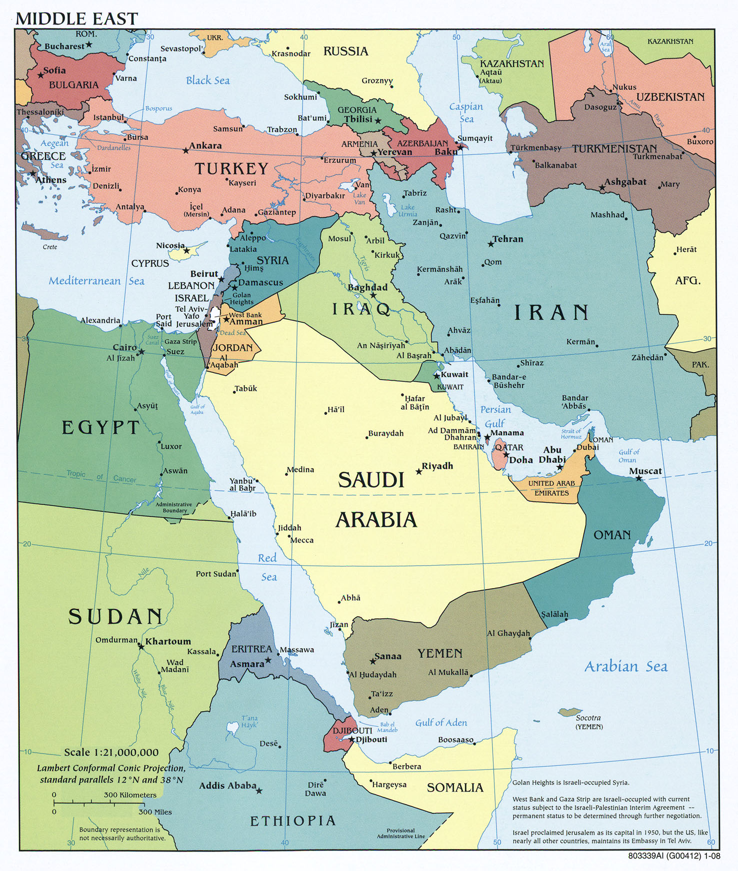
Today, the Middle Eastern Studies program at Bridgewater State University welcomes students from the Bridgewater-Raynham for a series of discussions about the Middle East. This is a world region that includes parts of northern Africa and southwestern Asia. This is not an EarthView program, in that we will not be setting up the globe, but EarthView coordinators Dr. Domingo and Dr. Hayes-Bohanan are meeting these middle school and high school students to talk about this dynamic region of the world from a geographic perspective.
We share here a number of the online resources we are sharing with those students, and hope that other EarthView participants will find them as interesting as we do!
We begin with a reference map from the excellent Perry-Castañeda collection at the University of Texas-Austin. This is a great source for definitive maps for class projects, by the way. Even in this collection, however, it is clear that the term "Middle East" does not have a single, consistent definition.
The Guardian UK newspaper has published The Path of Protest -- a timeline of the protests, activities, and political changes in more than a dozen countries of the region since late 2010, when The Arab Spring began in Tunisia. Use it to follow events in any country of the region, or to see how much activity took place in any given week. We learn, for example, that today's presentation is on the first anniversary of a major protest march in the Yemeni capital of Sana'a -- where such events were previously unheard of -- that drew tens of thousands of people into the streets.
 Some of these activities took place in coffee shops, by the way! The first coffee shops were located in what is now Saudi Arabia, and it was nearly 500 years ago that a political leader -- the governor of Mecca -- shut down a coffee shop for the first time. The role of coffee shops in the Arab spring is included in Cafe Stories.
We also spoke briefly about the concept of orientalism, as illustrated by the use of Arab images in coffee advertising.
We can examine the geography of the Middle East -- or any other region -- using a dynamic new online atlas called Show World, which includes dynamic cartograms that display the countries of the world whose size is shown in proportion to such variables as population, economic activity, military spending, and even coffee production! Although coffee is called Arabica because it was first cultivated in Arabia, and it is still consumed in the region, almost no coffee is now produced there. This online atlas is full of similar surprises!


As in all parts of the world, religions help to shape the human geography of the Middle East. A time-lapse of the "Big 5" religions helps viewers to understand the Middle East in the context of cultural geography at a global scale.
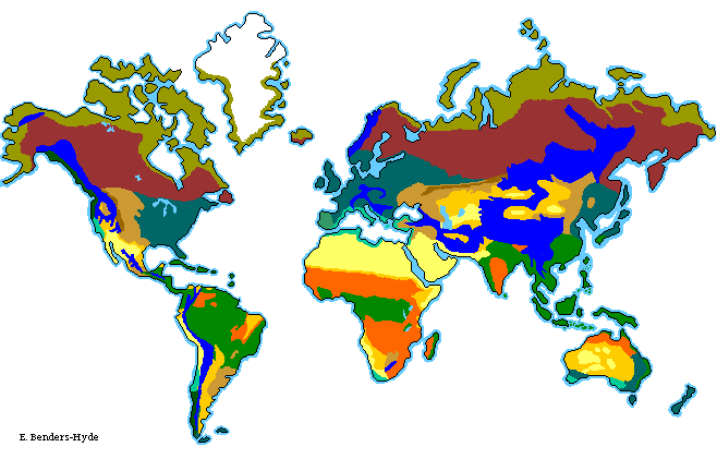
The physical geography of the Middle East is dominated by its dry climate, which is mainly the result of global circulation patterns that cause high pressure to dominate the region. In areas of high pressure, air is stable or descending, making cloud formation rare. This simple video depicts a simplified model of those patterns on the Western Hemisphere, but correctly indicates the factors that dominate climate in the Middle East.
The resultant climate is reflected in the desert and grassland biomes of the region.
We share here a number of the online resources we are sharing with those students, and hope that other EarthView participants will find them as interesting as we do!
We begin with a reference map from the excellent Perry-Castañeda collection at the University of Texas-Austin. This is a great source for definitive maps for class projects, by the way. Even in this collection, however, it is clear that the term "Middle East" does not have a single, consistent definition.
The Guardian UK newspaper has published The Path of Protest -- a timeline of the protests, activities, and political changes in more than a dozen countries of the region since late 2010, when The Arab Spring began in Tunisia. Use it to follow events in any country of the region, or to see how much activity took place in any given week. We learn, for example, that today's presentation is on the first anniversary of a major protest march in the Yemeni capital of Sana'a -- where such events were previously unheard of -- that drew tens of thousands of people into the streets.
 |
| Arab Spring Timeline from the Guardian UK |

We also spoke briefly about the concept of orientalism, as illustrated by the use of Arab images in coffee advertising.
We can examine the geography of the Middle East -- or any other region -- using a dynamic new online atlas called Show World, which includes dynamic cartograms that display the countries of the world whose size is shown in proportion to such variables as population, economic activity, military spending, and even coffee production! Although coffee is called Arabica because it was first cultivated in Arabia, and it is still consumed in the region, almost no coffee is now produced there. This online atlas is full of similar surprises!
We will spend part of our session exploring the new education materials from National Geographic Education.
The web site of the Newseum in Washington, DC is a great source of geographic and linguistic education. Every day, the front pages of more than 700 newspapers -- the "first draft of history" -- are displayed, just as they appear on news stands in thousands of cities throughout the world. Not only can we see what is happening, we can see what editors consider important in different parts of the world, or for different audiences in the same part of the world.
We also viewed a 5,000-year time-lapse map of the empires of the region, which ends with the formation of independent states within the past half-century or so.
As in all parts of the world, religions help to shape the human geography of the Middle East. A time-lapse of the "Big 5" religions helps viewers to understand the Middle East in the context of cultural geography at a global scale.
The physical geography of the Middle East is dominated by its dry climate, which is mainly the result of global circulation patterns that cause high pressure to dominate the region. In areas of high pressure, air is stable or descending, making cloud formation rare. This simple video depicts a simplified model of those patterns on the Western Hemisphere, but correctly indicates the factors that dominate climate in the Middle East.
The resultant climate is reflected in the desert and grassland biomes of the region.
Monday, April 9, 2012
Family Geography Night -- East Middle School in Braintree
42°13'15"N
We are delighted that TWO schools in Braintree have adopted the Family Geography Night concept, making it their own. These are both schools with geographic names -- South and East -- and more importantly they are schools where we encounter a lot of students with a sound understanding of the concepts of geography and an enthusiasm for learning more. Clearly, the excellent educators we have met at both schools -- and in Braintree's central administration -- have a lot to do with that. We are very pleased to be spending another evening with these educators, their students, and the families who support all this learning.
Since the EarthView Team visited South Middle School just a fortnight ago, it would be good to compare the coordinates of the two schools. Which is farther south? East? By what portion of a degree? Where would the antipodes of these schools be (See the "more about" link above for this one.)
 |
| From the town web site -- click to enlarge seal & map. |
Aside from a striking name borrowed from a town in England, Braintree is a fascinating study in both history and geography. The blog post for our September 2011 visit to East Middle includes some discussion of the town's unusual seal, and also references the situation of the town. Geographers use the word "site" to refer to the characteristics of a place, while "situation" refers to the ways it is connected to (or separated from) other places or the broader region. Braintree is south of Boston, and includes one of the most important intersections in southern New England, as traffic leaving Boston is split between those headed south and east toward Cape Cod and those headed south and west toward the South Coast of Massachusetts or the I-95 corridor. Where outgoing traffic splits, incoming traffic converges. Braintree is also at the periphery of the municipal rail system for Boston, includes access to ferries (directly or through neighboring towns), and a major terminal for bus service to Logan Airport.
The convergence of these transportation networks creates a point of very high accessibility -- and therefore property value, especially commercial. This in turn has made Braintree a logical site for major office and shopping infrastructure. Combined with its role in the nation's history and the complexity of the coastal topography, Braintree is an ideal place to learn geography!
Saturday, April 7, 2012
EarthView Institute Continued -- April 7
Today we have had the continuation of the EarthView Institute, which we began last week. The EarthView team is preparing eleven teachers from throughout the state to run EarthView programs on their own.
We began the day with an activity about climate classification, and discussed the relationship between climates and biomes. Once in the gym, our "Globe Wrangler" Brigitta used a small globe from the age of the dinosaurs to illustrate the movement continents resulting from plate tectonics. She later shared a lesson on the geography of Alaska, where she had lived as a child.
 `
`
The teacher participants spent time describing their own ideas about using EarthView with their students, and they practiced caring for EarthView, inflating and deflating it.

We then spent some time in the Global Education Center, a curriculum-resource room that the Department of Geography operates in conjunction with the Massachusetts Geographic Alliance. We examined both print and online resources, including Earth at Night, GeoChron, the Kony 2012 BSU blog, and the Nintendo version of Google Maps.

We also spent some time looking at patterns of air traffic. (Note: this is an accelerated summary, not in real time.)
We began the day with an activity about climate classification, and discussed the relationship between climates and biomes. Once in the gym, our "Globe Wrangler" Brigitta used a small globe from the age of the dinosaurs to illustrate the movement continents resulting from plate tectonics. She later shared a lesson on the geography of Alaska, where she had lived as a child.
 `
`The teacher participants spent time describing their own ideas about using EarthView with their students, and they practiced caring for EarthView, inflating and deflating it.

We then spent some time in the Global Education Center, a curriculum-resource room that the Department of Geography operates in conjunction with the Massachusetts Geographic Alliance. We examined both print and online resources, including Earth at Night, GeoChron, the Kony 2012 BSU blog, and the Nintendo version of Google Maps.
We also spent some time looking at patterns of air traffic. (Note: this is an accelerated summary, not in real time.)
Subscribe to:
Posts (Atom)